Difference between revisions of "2014-05-21 47 -122"
imported>Thomcat ([live picture] Nearby proposed project [http://www.openstreetmap.org/?lat=47.75307133&lon=-122.21405240&zoom=16&layers=B000FTF @47.7531,-122.2141]) |
imported>FippeBot m (Location) |
||
| (7 intermediate revisions by 2 users not shown) | |||
| Line 1: | Line 1: | ||
| − | |||
| − | |||
| − | |||
| − | |||
| − | |||
| − | |||
| − | |||
| − | |||
| − | |||
| − | |||
{{meetup graticule | {{meetup graticule | ||
| lat=47 | | lat=47 | ||
| lon=-122 | | lon=-122 | ||
| date=2014-05-21 | | date=2014-05-21 | ||
| + | | graticule_name=Seattle | ||
| + | | graticule_link=Seattle, Washington | ||
}} | }} | ||
| Line 18: | Line 10: | ||
__NOTOC__ | __NOTOC__ | ||
== Location == | == Location == | ||
| − | + | A hillside off 95th Avenue in Bothell | |
== Participants == | == Participants == | ||
| − | + | * [[User:Thomcat|Thomcat]] | |
| − | + | * [[User:Olofhellman|Olof]] | |
== Plans == | == Plans == | ||
| − | + | Drive by on morning commute, possible return afternoon. | |
== Expedition == | == Expedition == | ||
| − | |||
| − | + | (Thomcat) | |
| − | + | At first I merely planned to drive by and snap a photo of the spot. Reached the neighborhood easily enough, spotted a nearby "change of land use" sign, thought it might be worth parking to investigate further. | |
| + | |||
| + | Once parked, I walked to the edge of the lot and discovered the geohash to be only a few steps away - in fact, it seemed to be where a neighbor has been (probably illegally) dumping grass clippings. I snapped some photos of the spot and uploaded, and said neighbor's small dog made an appearance. My friendly wave was met with "he will bite you" and other friendly comments. | ||
| + | |||
| + | Instead of going into a description of the sport, I merely explained I was taking some photos of this lot, you know, for the land use thingy. :-) | ||
| + | |||
| + | Anyhow, geohash achieved. You might see in the photo I am wearing the same shirt I wore for my very first geohash nearly six years ago. This marks my 125th successful geohash, and both my and Seattle's first [[Geohashing Day]] success (we got Mouseover last year). | ||
| + | |||
| + | (Olof) | ||
| + | Took a late night walk and got to the location at quarter to midnight, as it is just 5 minutes from my home. Too dark to see Thomcat's marker. First geohash achieved! Also, as this was 400 m from my home, it's a couch potato honorable mention! | ||
| + | |||
== Photos == | == Photos == | ||
| Line 46: | Line 47: | ||
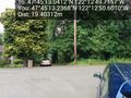
Image:2014-05-21_47_-122_thomcat_1400684820406.jpg | Nearby proposed project [http://www.openstreetmap.org/?lat=47.75307133&lon=-122.21405240&zoom=16&layers=B000FTF @47.7531,-122.2141] | Image:2014-05-21_47_-122_thomcat_1400684820406.jpg | Nearby proposed project [http://www.openstreetmap.org/?lat=47.75307133&lon=-122.21405240&zoom=16&layers=B000FTF @47.7531,-122.2141] | ||
| + | |||
| + | Image:2014-05-21_47_-122_thomcat_1400684913395.jpg | Success! [http://www.openstreetmap.org/?lat=47.75359344&lon=-122.21394685&zoom=16&layers=B000FTF @47.7536,-122.2139] | ||
| + | |||
| + | Image:2014-05-21_47_-122_thomcat_-1.jpg | Marker [http://www.openstreetmap.org/?lat=47.75359925&lon=-122.21394950&zoom=16&layers=B000FTF @47.7536,-122.2139] | ||
</gallery> | </gallery> | ||
== Achievements == | == Achievements == | ||
| − | {{ | + | {{Geohashing Day | latitude = 47 | longitude = -122 | coorddate = 2014-05-21 | year = 2014 | name = Thomcat | image = 2014-05-21 47 -122 thomcat 1400684913395.jpg}} |
| − | + | {{Geohashing Day | latitude = 47 | longitude = -122 | coorddate = 2014-05-21 | year = 2014 | name = Olofhellman }} | |
| − | |||
| − | |||
| − | |||
| − | |||
| − | |||
| − | |||
| − | |||
| − | |||
| − | |||
| − | |||
| − | |||
| − | |||
| − | |||
[[Category:Expeditions]] | [[Category:Expeditions]] | ||
| − | |||
[[Category:Expeditions with photos]] | [[Category:Expeditions with photos]] | ||
| − | |||
| − | |||
| − | |||
| − | |||
| − | |||
[[Category:Coordinates reached]] | [[Category:Coordinates reached]] | ||
| − | + | {{location|US|WA|KN}} | |
| − | |||
| − | |||
| − | |||
| − | |||
| − | |||
| − | |||
| − | |||
| − | |||
| − | |||
| − | |||
| − | |||
| − | |||
| − | |||
| − | |||
| − | |||
| − | |||
| − | |||
Latest revision as of 06:35, 14 August 2019
| Wed 21 May 2014 in Seattle: 47.7536225, -122.2138099 geohashing.info google osm bing/os kml crox |
Location
A hillside off 95th Avenue in Bothell
Participants
Plans
Drive by on morning commute, possible return afternoon.
Expedition
(Thomcat) At first I merely planned to drive by and snap a photo of the spot. Reached the neighborhood easily enough, spotted a nearby "change of land use" sign, thought it might be worth parking to investigate further.
Once parked, I walked to the edge of the lot and discovered the geohash to be only a few steps away - in fact, it seemed to be where a neighbor has been (probably illegally) dumping grass clippings. I snapped some photos of the spot and uploaded, and said neighbor's small dog made an appearance. My friendly wave was met with "he will bite you" and other friendly comments.
Instead of going into a description of the sport, I merely explained I was taking some photos of this lot, you know, for the land use thingy. :-)
Anyhow, geohash achieved. You might see in the photo I am wearing the same shirt I wore for my very first geohash nearly six years ago. This marks my 125th successful geohash, and both my and Seattle's first Geohashing Day success (we got Mouseover last year).
(Olof) Took a late night walk and got to the location at quarter to midnight, as it is just 5 minutes from my home. Too dark to see Thomcat's marker. First geohash achieved! Also, as this was 400 m from my home, it's a couch potato honorable mention!
Photos
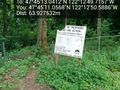
View into the hash point @47.7537,-122.2141
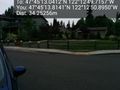
Park across the street @47.7538,-122.2141
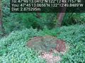
Grass pile of geohash @47.7536,-122.2138
Nearby proposed project @47.7531,-122.2141
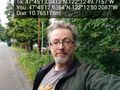
Success! @47.7536,-122.2139
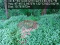
Marker @47.7536,-122.2139


Achievements
Thomcat earned the 2014 Geohashing Day achievement
|
Olofhellman earned the 2014 Geohashing Day achievement
|