Difference between revisions of "2014-05-21 49 10"
imported>Schnatterfleck (The hashpoint as located by my GPS - surprisingly nice area! Schnatterfleck [http://www.openstreetmap.org/?lat=49.36880000&lon=10.82900000&zoom=16&layers=B000FTF @49.3688,10.8290]) |
m (Location correction) |
||
| (15 intermediate revisions by 3 users not shown) | |||
| Line 15: | Line 15: | ||
}} | }} | ||
| − | + | ||
__NOTOC__ | __NOTOC__ | ||
== Location == | == Location == | ||
| − | + | A wood near Raitersaich | |
| + | |||
== Participants == | == Participants == | ||
| − | + | ||
| − | + | * [[User:Schnatterfleck|Schnatterfleck]] | |
== Plans == | == Plans == | ||
| Line 28: | Line 29: | ||
== Expedition == | == Expedition == | ||
| − | + | ||
| + | I always wanted to go hunt some hash points. But using the web based tools was always too complicated. | ||
| + | But this week I discovered the geohashing app in the Android store - and it works perfectly! :-) | ||
| + | |||
| + | |||
| + | And on this really, really nice day (warm and sunny), it showed me a coordinate that was: | ||
| + | |||
| + | - just within reach for me during the 3 or four hours I had to spare (I am nearly always going by bike...) | ||
| + | |||
| + | - apparently located only a few meters from a road near an open field | ||
| + | |||
| + | - situated in a really nice rural landscape. | ||
| + | |||
| + | |||
| + | So off I went, leaving work a little early and setting the hash point as a target in my brand new routing software (OSMAnd). | ||
| + | |||
| + | I knew that routing for bicycles is a magnitude harder than car routing. | ||
| + | That combined with the remaining inconsistencies of OSM map material (although that is rather good around Nuremberg) lead to a rather... interesting... route that I was led. | ||
| + | I got the impression that the routing algorithm itself sometimes used some kind of geohashing-like algorithms. | ||
| + | |||
| + | Additionally it didn't help that OSMAnd's UI is rather car-centric. | ||
| + | |||
| + | All this led to a lot of this kind of situation: | ||
| + | |||
| + | '''OSMAnd''': Turn right! | ||
| + | |||
| + | '''Me''': But there is no road. | ||
| + | |||
| + | '''OSMAnd''': Yes there is! | ||
| + | |||
| + | '''Me''': No, there isn't! | ||
| + | |||
| + | '''OSMAnd''': Believe me, there is! Look at my map! | ||
| + | |||
| + | '''Me''': YOU believe ME, in reality there is no road! | ||
| + | |||
| + | '''OSMAnd''': Ok, here is your choice: Either you believe there to be a road and take it, or track your way back for the last two or three kilometres and try something different on your own... | ||
| + | |||
| + | '''Me''': *Gnaaarg* | ||
| + | |||
| + | |||
| + | So going to the hashpoint was really, really fun. A great adventure that I am still thinking about with a silly smile on my face :) | ||
| + | |||
| + | The hashpoint itself was rather unspectacular. | ||
| + | |||
| + | And very nearly it was a Déjà Vu Geohash, as it lay just a view hundred meters from the riding stable were we sometimes rent a pony for a little tour with our young niece. | ||
== Tracklog == | == Tracklog == | ||
| Line 34: | Line 80: | ||
== Photos == | == Photos == | ||
| − | + | ||
| − | |||
| − | |||
<gallery perrow="5"> | <gallery perrow="5"> | ||
Image:2014-05-21_49_10_Schnatterfleck_-1.jpg | The hashpoint as located by my GPS - surprisingly nice area! Schnatterfleck [http://www.openstreetmap.org/?lat=49.36880000&lon=10.82900000&zoom=16&layers=B000FTF @49.3688,10.8290] | Image:2014-05-21_49_10_Schnatterfleck_-1.jpg | The hashpoint as located by my GPS - surprisingly nice area! Schnatterfleck [http://www.openstreetmap.org/?lat=49.36880000&lon=10.82900000&zoom=16&layers=B000FTF @49.3688,10.8290] | ||
| + | |||
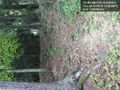
| + | Image:2014-05-21_49_10_Schnatterfleck_1400683035587.jpg | Aeaeah... Routing app?... You're kidding, right...?? [http://www.openstreetmap.org/?lat=49.41280000&lon=10.90250000&zoom=16&layers=B000FTF @49.4128,10.9025] | ||
| + | |||
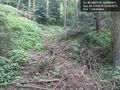
| + | Image:2014-05-21_49_10_Schnatterfleck_1400683097989.jpg | Really steep (more than it looks on the picture)... but also part of the calculated route. Fallback to pushing the bike (at least not carrying yet...) [http://www.openstreetmap.org/?lat=49.41240000&lon=10.90340000&zoom=16&layers=B000FTF @49.4124,10.9034] | ||
| + | |||
| + | Image:2014-05-21_49_10_Schnatterfleck_1400682812018.jpg | THIS is how I like it :) - But the near dead-end already lurked at the bottom of the little valley.... [http://www.openstreetmap.org/?lat=49.40950000&lon=10.89500000&zoom=16&layers=B000FTF @49.4095,10.8950] | ||
| + | |||
| + | Image:2014-05-21_49_10_Schnatterfleck_1400680990831.jpg | Mission accomplished! [http://www.openstreetmap.org/?lat=49.36870000&lon=10.82880000&zoom=16&layers=B000FTF @49.3687,10.8288] | ||
| + | |||
| + | Image:2014-05-21_49_10_Schnatterfleck_1400680218339.jpg | Not very far from the hash point. And I actually know those horses. [http://www.openstreetmap.org/?lat=49.36990000&lon=10.83570000&zoom=16&layers=B000FTF @49.3699,10.8357] | ||
| + | |||
| + | Image:2014-05-21_49_10_Schnatterfleck_1400678030928.jpg | I was actually routed right through the middle of a golf course! [http://www.openstreetmap.org/?lat=49.37810000&lon=10.97750000&zoom=16&layers=B000FTF @49.3781,10.9775] | ||
</gallery> | </gallery> | ||
| Line 46: | Line 102: | ||
<!-- Add any achievement ribbons you earned below, or remove this section --> | <!-- Add any achievement ribbons you earned below, or remove this section --> | ||
| + | * Land geohash | ||
| + | * Bike geohash | ||
| − | |||
| − | |||
| − | |||
| − | |||
| − | |||
| − | |||
| − | |||
| − | |||
| − | |||
| − | |||
| − | |||
[[Category:Expeditions]] | [[Category:Expeditions]] | ||
| − | |||
[[Category:Expeditions with photos]] | [[Category:Expeditions with photos]] | ||
| − | |||
| − | |||
| − | |||
| − | |||
| − | |||
[[Category:Coordinates reached]] | [[Category:Coordinates reached]] | ||
| − | + | {{location|DE|BY|AN}} | |
| − | |||
| − | |||
| − | |||
| − | |||
| − | |||
| − | |||
| − | |||
| − | |||
| − | |||
| − | |||
| − | |||
| − | |||
| − | |||
| − | |||
| − | |||
| − | |||
| − | |||
Latest revision as of 20:23, 16 May 2020
| Wed 21 May 2014 in 49,10: 49.3687540, 10.8289638 geohashing.info google osm bing/os kml crox |
Location
A wood near Raitersaich
Participants
Plans
Expedition
I always wanted to go hunt some hash points. But using the web based tools was always too complicated. But this week I discovered the geohashing app in the Android store - and it works perfectly! :-)
And on this really, really nice day (warm and sunny), it showed me a coordinate that was:
- just within reach for me during the 3 or four hours I had to spare (I am nearly always going by bike...)
- apparently located only a few meters from a road near an open field
- situated in a really nice rural landscape.
So off I went, leaving work a little early and setting the hash point as a target in my brand new routing software (OSMAnd).
I knew that routing for bicycles is a magnitude harder than car routing. That combined with the remaining inconsistencies of OSM map material (although that is rather good around Nuremberg) lead to a rather... interesting... route that I was led. I got the impression that the routing algorithm itself sometimes used some kind of geohashing-like algorithms.
Additionally it didn't help that OSMAnd's UI is rather car-centric.
All this led to a lot of this kind of situation:
OSMAnd: Turn right!
Me: But there is no road.
OSMAnd: Yes there is!
Me: No, there isn't!
OSMAnd: Believe me, there is! Look at my map!
Me: YOU believe ME, in reality there is no road!
OSMAnd: Ok, here is your choice: Either you believe there to be a road and take it, or track your way back for the last two or three kilometres and try something different on your own...
Me: *Gnaaarg*
So going to the hashpoint was really, really fun. A great adventure that I am still thinking about with a silly smile on my face :)
The hashpoint itself was rather unspectacular.
And very nearly it was a Déjà Vu Geohash, as it lay just a view hundred meters from the riding stable were we sometimes rent a pony for a little tour with our young niece.
Tracklog
Photos
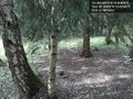
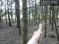
The hashpoint as located by my GPS - surprisingly nice area! Schnatterfleck @49.3688,10.8290
Aeaeah... Routing app?... You're kidding, right...?? @49.4128,10.9025
Really steep (more than it looks on the picture)... but also part of the calculated route. Fallback to pushing the bike (at least not carrying yet...) @49.4124,10.9034
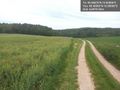
THIS is how I like it :) - But the near dead-end already lurked at the bottom of the little valley.... @49.4095,10.8950
Mission accomplished! @49.3687,10.8288
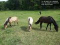
Not very far from the hash point. And I actually know those horses. @49.3699,10.8357
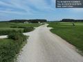
I was actually routed right through the middle of a golf course! @49.3781,10.9775


Achievements
- Land geohash
- Bike geohash