Difference between revisions of "2014-05-29 48 8"
imported>RecentlyChanged (→Location) |
imported>FippeBot m (Location) |
||
| (6 intermediate revisions by 3 users not shown) | |||
| Line 21: | Line 21: | ||
== Participants == | == Participants == | ||
| − | + | [[User:RecentlyChanged|RecentlyChanged]] and his mum. | |
| − | |||
| − | == | + | == Expedition == |
| − | + | I had to transport a tent to a friend, so I decided to make a motorcycle tour. | |
| + | I knew the Hash is nearby, but I did not want to go there, because I had to learn for university (like in this moment too), but the excuse was good enough to do it anyway. My mom came home from her tour just a few minutes ago, so she was still in her dress for motorcycling and she helped me to transport the tent. | ||
| + | |||
| + | After we dropped our package we made our way to the Hashpoint. | ||
| + | At first I thought it went good. Until we were on top of the hill and we saw what lay behind! | ||
| + | It was a dense wall of rain! I stopped to look up the location of the Hash and ask my mum whether to go on or not. She did not even flinch an eye on the significant rain and said: how do we get there? let's be fast! | ||
| + | We got there... but not fast. | ||
| + | |||
| + | It rained heavily and I took a few wrong turns, in the end we even stopped, walked half of the way through a field, walked back, parked somewhere else and walked again. | ||
| + | |||
| + | On the map I did not see, that the Hashpoint is really near a house, probably on private property, but it was just a vacation house and nobody was in sight. In the end we did not leave the path anyway. | ||
| − | + | On the top of the hill, where we stopped first, I made a photo of our beautiful landscape. Which is even beautiful when the weather is really bad. | |
| − | + | On the picture you can see below you can see a big house, that's the home of "Die Fallers", a famous tv-show in germany (Even I heard about it, though it's more for older people (fans: no offense)) A link to it is [http://www.swr.de/diefallers/-/id=98556/1fx2r2p/ here] and here's the [http://de.wikipedia.org/wiki/Die_Fallers_%E2%80%93_Eine_Schwarzwaldfamilie wiki entrance]. The soap had over 800 episodes in about 20 years! | |
| + | In the end me and my mum were soaked through almost every layer, especially our shoes, so we went back as fast as possible. | ||
| + | My mum and I totally agree, that geohashing is a stupid sport! Still I love it and she would do it again too. | ||
== Tracklog == | == Tracklog == | ||
| − | + | http://www.everytrail.com/view_trip.php?trip_id=2800190 | |
== Photos == | == Photos == | ||
| − | + | ||
| − | |||
| − | |||
<gallery perrow="5"> | <gallery perrow="5"> | ||
| Line 46: | Line 55: | ||
== Achievements == | == Achievements == | ||
{{#vardefine:ribbonwidth|800px}} | {{#vardefine:ribbonwidth|800px}} | ||
| − | + | {{land geohash | |
| + | | latitude = 48 | ||
| + | | longitude = 8 | ||
| + | | date = 2014-05-29 | ||
| + | | name = RecentlyChanged and his mum | ||
| − | + | }} | |
| − | |||
| − | |||
| − | + | {{Drowned rat geohash | |
| + | | latitude = 48 | ||
| + | | longitude = 8 | ||
| + | | date = 2014-05-29 | ||
| + | | name = RecentlyChanged and his mum | ||
| + | | reason = driving with the motorcycle through heavy rain | ||
| − | + | }} | |
| − | + | {{Two to the N achievement | |
| − | + | | count = 1 | |
| − | + | | date = 2014-05-29 | |
| + | | latitude = 48 | ||
| + | | longitude = 8 | ||
| + | | name = RCs mother | ||
| + | | reached = true | ||
| + | }} | ||
| − | |||
[[Category:Expeditions]] | [[Category:Expeditions]] | ||
| − | + | ||
[[Category:Expeditions with photos]] | [[Category:Expeditions with photos]] | ||
| − | + | ||
| − | |||
| − | |||
| − | |||
| − | |||
[[Category:Coordinates reached]] | [[Category:Coordinates reached]] | ||
| − | + | {{location|DE|BW|VS}} | |
| − | |||
| − | |||
| − | |||
| − | |||
| − | |||
| − | |||
| − | |||
| − | |||
| − | |||
| − | |||
| − | |||
| − | |||
| − | |||
| − | |||
| − | |||
| − | |||
| − | |||
Latest revision as of 06:43, 14 August 2019
| Thu 29 May 2014 in 48,8: 48.0348536, 8.1316679 geohashing.info google osm bing/os kml crox |
Location
In the beautiful Black forest! (Even on a existing path!)
Participants
RecentlyChanged and his mum.
Expedition
I had to transport a tent to a friend, so I decided to make a motorcycle tour. I knew the Hash is nearby, but I did not want to go there, because I had to learn for university (like in this moment too), but the excuse was good enough to do it anyway. My mom came home from her tour just a few minutes ago, so she was still in her dress for motorcycling and she helped me to transport the tent.
After we dropped our package we made our way to the Hashpoint. At first I thought it went good. Until we were on top of the hill and we saw what lay behind! It was a dense wall of rain! I stopped to look up the location of the Hash and ask my mum whether to go on or not. She did not even flinch an eye on the significant rain and said: how do we get there? let's be fast! We got there... but not fast.
It rained heavily and I took a few wrong turns, in the end we even stopped, walked half of the way through a field, walked back, parked somewhere else and walked again.
On the map I did not see, that the Hashpoint is really near a house, probably on private property, but it was just a vacation house and nobody was in sight. In the end we did not leave the path anyway.
On the top of the hill, where we stopped first, I made a photo of our beautiful landscape. Which is even beautiful when the weather is really bad. On the picture you can see below you can see a big house, that's the home of "Die Fallers", a famous tv-show in germany (Even I heard about it, though it's more for older people (fans: no offense)) A link to it is here and here's the wiki entrance. The soap had over 800 episodes in about 20 years!
In the end me and my mum were soaked through almost every layer, especially our shoes, so we went back as fast as possible. My mum and I totally agree, that geohashing is a stupid sport! Still I love it and she would do it again too.
Tracklog
http://www.everytrail.com/view_trip.php?trip_id=2800190
Photos
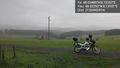
Significant rain, but still beautiful landscape! @48.0329,8.1318
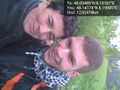
grinning with my mum :)


Achievements
RecentlyChanged and his mum earned the Land geohash achievement
|
RecentlyChanged and his mum earned the Drowned Rat Geohash Achievement
|
