Difference between revisions of "2014-06-05 50 -114"
imported>Guzzby (→Plans) |
m (More specific location) |
||
| (8 intermediate revisions by 2 users not shown) | |||
| Line 33: | Line 33: | ||
== Expedition == | == Expedition == | ||
<!-- how it all turned out. your narrative goes here. --> | <!-- how it all turned out. your narrative goes here. --> | ||
| − | + | I got to the Parking area for Ings Mine Trailhead around 10:30am. The bridge over the creek on the trail was knocked out by the flood last year, so I headed north to see if there was another bridge I could use. I was stopped by a forestry worker who was warning everyone about a grizzly bear that was seen in the area. I then headed back south to Hwy 66 and parked on the side of the road on the other side of the creek. I headed into the forest and followed the trails and found several geocaches. The weather started turning and it began raining lightly. As I headed up the mountain it changed to a light snow fall. When I reached the "Tree Chopper Trail Cache", I followed the nearby trail to within 100 meters of the geohash. I then headed into the forest and bush whacked my way to ground zero. I took a couple of pictures and then returned to the trail. When I got back to the trail the weather had changed to a steady downpour. I walked another 2 km along the trails and collected three more geocaches before returning to my car. | |
| − | |||
| − | |||
== Photos == | == Photos == | ||
| Line 42: | Line 40: | ||
--> | --> | ||
<gallery perrow="5"> | <gallery perrow="5"> | ||
| + | Image:2014-06-05_50_-114_guzzby1.jpg | North View | ||
| + | Image:2014-06-05_50_-114_guzzby2.jpg | East View | ||
| + | Image:2014-06-05_50_-114_guzzby3.jpg | West View | ||
| + | Image:2014-06-05_50_-114_guzzby4.jpg | South View | ||
</gallery> | </gallery> | ||
| Line 47: | Line 49: | ||
{{#vardefine:ribbonwidth|800px}} | {{#vardefine:ribbonwidth|800px}} | ||
<!-- Add any achievement ribbons you earned below, or remove this section --> | <!-- Add any achievement ribbons you earned below, or remove this section --> | ||
| − | + | {{Land geohash | latitude = 50 | longitude = -114 | date = 2014-06-05 | name = [[User:Guzzby|Guzzby]] }} | |
| − | |||
| − | |||
| − | |||
| − | [[ | ||
<!-- ==REQUEST FOR TWITTER BOT== Please leave either the New report or the Expedition planning category in as long as you work on it. This helps the twitter bot a lot with announcing the right outcome at the right moment. --> | <!-- ==REQUEST FOR TWITTER BOT== Please leave either the New report or the Expedition planning category in as long as you work on it. This helps the twitter bot a lot with announcing the right outcome at the right moment. --> | ||
| − | |||
| − | |||
| − | |||
| − | |||
| − | |||
| − | |||
[[Category:Expeditions]] | [[Category:Expeditions]] | ||
| − | |||
[[Category:Expeditions with photos]] | [[Category:Expeditions with photos]] | ||
| − | |||
| − | |||
| − | |||
| − | |||
| − | |||
[[Category:Coordinates reached]] | [[Category:Coordinates reached]] | ||
| − | + | {{location|CA|AB|KA}} | |
| − | |||
| − | |||
| − | |||
| − | |||
| − | |||
| − | |||
| − | |||
| − | |||
| − | |||
| − | |||
| − | |||
| − | |||
| − | |||
| − | |||
| − | |||
| − | |||
| − | |||
Latest revision as of 00:08, 10 August 2020
| Thu 5 Jun 2014 in 50,-114: 50.8782627, -114.7394333 geohashing.info google osm bing/os kml crox |
Location
8 Km Southwest of Bragg Creek, Alberta Canada. In the forest east of Moose Mountain RD.
Participants
Plans
Planned on driving to the Parking area for Ings Mine Trailhead on Range Road 62A around 10:00am. I was going to walk around the forest trails and find geocaches in the area. When I was near the "Tree Chopper Trail Cache" on Moose Mountain Rd, I was going to bush whack into the forest and get to the geohash.
Expedition
I got to the Parking area for Ings Mine Trailhead around 10:30am. The bridge over the creek on the trail was knocked out by the flood last year, so I headed north to see if there was another bridge I could use. I was stopped by a forestry worker who was warning everyone about a grizzly bear that was seen in the area. I then headed back south to Hwy 66 and parked on the side of the road on the other side of the creek. I headed into the forest and followed the trails and found several geocaches. The weather started turning and it began raining lightly. As I headed up the mountain it changed to a light snow fall. When I reached the "Tree Chopper Trail Cache", I followed the nearby trail to within 100 meters of the geohash. I then headed into the forest and bush whacked my way to ground zero. I took a couple of pictures and then returned to the trail. When I got back to the trail the weather had changed to a steady downpour. I walked another 2 km along the trails and collected three more geocaches before returning to my car.
Photos
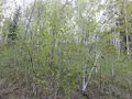
North View
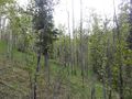
East View
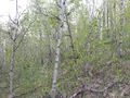
West View
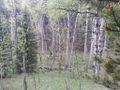
South View


Achievements
Guzzby earned the Land geohash achievement
|