| Fri 6 Jun 2014 in 50,11: 50.8833173, 11.5597951 geohashing.info google osm bing/os kml crox |
Location
On a field near Oßmaritz. Also apparently near business providing "stylish obituaries" <- Whaaaat?
Participants
Plans
This is quite close to where I work, so I plan to leave work at 3, get to the point at 4 or so? Looks like I'll take mostly hiking paths, though I'll have my bike with me, so that'll slow me down. ScepticAnna (talk)
Maybe I will come there too, but later. Can't leave work at 3 pm. Jens
--- Yeah, I usually work 6 to 3, so I buy my early afternoons with early mornings ;-) I'll try to remember and leave a sign this time for you to find later. ScepticAnna (talk)
I'll probably compete with Jens for Latest Geohasher of today. -Juja
Expedition
Anna
After leaving work half an hour later than planned, I left via Göschwitz. While the hiking path between Göschwitz and Oßmaritz is quite broad and as good for biking as a hiking path gets, I pushed my bike part of the way because the climb was too steep for my lungs. On top of the hill, I took a nice grassy path to a small farm. My GPS wanted me to go through the farm, but I didn't want to trespass and the map showed a small path that would get me there. I went looking for that path and at first didn't find it. Finally I spoke with a woman who was searching for a different path and she pointed it out to me: it was quite overgrown. The woman's path turned out to be hiding behind a tall stack of wood.
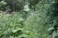
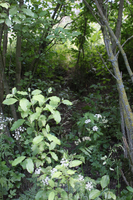
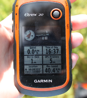
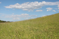
I followed the overgrown path to 12 meters away from the point and realized that I would have to break through some bushes to reach the point. After braving stinging nettles and thorny wild plums, I finally reached the point at the edge of a field of tall grass. The path I took through the bushes looked like someone had gone there before - some other geohashers, or just a sheep trail, who knows?
I'm sad to say that again I forgot to leave a sign. (I have an excuse: I was distracted by the many insects that were landing on me, making me itch and just want to leave)
On the way back to Jena, I took a path through Kleinertal valley, because someone had told me that there are lady's-slipper orchids there. I didn't see any, probably wasn't in the right place.
In Winzerla I think I met Juja, but I can't be sure because it was in a dark tunnel, she was wearing dark sunglasses and we passed each other very quickly, so who knows?
All in all it was a nice, sunny expedition,even though now the skin of my legs is itching from being hit by grass so much.
Jens
I decided to use the Ossmaritzer Str. from Winzerla to climb up to the point. As the name of that street already indicates it leads to the direct path from Winzerla to Ossmaritz. When you have to climb up a hill, the direct path may become steep. I knew this before, since I saw a lot of topographic contour line on the map I had to cross. But reality is always harder than a some small lines on a virtual sheet of paper. So I can quote from Anna: “…I pushed my bike part of the way because the climb was too steep for my lungs.” When the way reached the local top, I found myself in front of a transmitter mast, I have seen a lot of times before but never knew how to come there. Now I know.
Now I had to find the entrance to the overgrown path. I saw it, but was not sure, whether it was right, so I first cycled to Ossmaritz on and entered the small path from the other side, where it was easier to find. Next task was to overcome the brushes between the path and the meadow. I didn’t try it direct beside the point. Instead I went 50 meters along the path, where is was quiet easy. On the meadow I took some photos and wanted to leave a sign (I’m not sure whether Juja has already been here or not) but there was nothing here to create one. Or my creativity left me. So I built some kind of abstract art, that probably no one will ever identify as a mark. But I can say, I did my best.
For my way back home I used the official street to Ossmaritz, much more comfortable the path I used uphill.
Photos
Anna's Photos
|
Achievements


