Difference between revisions of "2014-06-14 50 8"
imported>Mampfred (Created page with "{{subst:Expedition |lat = 50 |lon = 8 |date = 2014-06-14 }}") |
imported>FippeBot m (Location) |
||
| (5 intermediate revisions by one other user not shown) | |||
| Line 1: | Line 1: | ||
| − | |||
| − | |||
| − | |||
| − | |||
| − | |||
| − | |||
| − | |||
| − | |||
| − | |||
| − | |||
{{meetup graticule | {{meetup graticule | ||
| lat=50 | | lat=50 | ||
| Line 15: | Line 5: | ||
}} | }} | ||
| − | |||
__NOTOC__ | __NOTOC__ | ||
== Location == | == Location == | ||
| − | + | In the woods "above" Lorsbach. | |
== Participants == | == Participants == | ||
| − | + | * [[User:M|M]] and [[User:QuarterCacher|QuarterCacher]] | |
| − | + | * [[User:LadyBB|LadyBB]] and [[User:Mampfred|Mampfred]] | |
| + | * Daniel | ||
== Plans == | == Plans == | ||
| − | + | We're rounded up already celebrating a birthday and suddenly noticed how close the hash is so we had to go. | |
== Expedition == | == Expedition == | ||
| − | + | The (mid)day started with a nice BBQ and an even nicer [http://coord.info/GC35TQZ climbing geocache] and after getting back and doing some more clmkbing practise on [[User:EmmJay|EmmJay]]s swing set we suddenly realized that the hash isn't very far. Amazingly, we were still all up to it so we changed clothes and got back in the car (leaving poor [[User:EmmJay|EmmJay]] behind with his grandmother - ah well). | |
| + | |||
| + | We drove as close as we could get and parked the car still some way off. Using a number of forest paths we wiggled our way up one of the omnipresent hills in our area and found the hash only a couple of meters off the track. Birthday geohash achievement for [[User:Mampfred|Mampfred]] :) | ||
| + | |||
| + | We even found [http://coord.info/GC494N5 another geocache] some 150 meters right next to out way back to the car. And for good measure we [http://www.ingress.com attacked a number of ingress portals] on the way back home. There should be another achievement for maximising the number of GPS based games you can play on a single outing ;) | ||
== Tracklog == | == Tracklog == | ||
| − | + | See [http://www.everytrail.com/view_trip.php?trip_id=2822990 here]. | |
== Photos == | == Photos == | ||
| − | |||
| − | |||
| − | |||
<gallery perrow="5"> | <gallery perrow="5"> | ||
| + | Image:2014-06-14_50_8_coordinates_reached.jpg | Coordinates reached | ||
| + | Image:2014-06-14_50_8_group_shot.jpg | Group shot | ||
</gallery> | </gallery> | ||
== Achievements == | == Achievements == | ||
{{#vardefine:ribbonwidth|800px}} | {{#vardefine:ribbonwidth|800px}} | ||
| − | + | {{Birthday geohash | latitude = 50 | longitude = 8 | date = 2014-06-14 | pronoun = his | number = 35th | name = [[User:Mampfred|Mampfred]]}} | |
| − | |||
| − | |||
| − | |||
| − | |||
| − | |||
| − | |||
| − | |||
| − | |||
| − | |||
| − | |||
| − | [[ | ||
| − | |||
| − | |||
[[Category:Expeditions]] | [[Category:Expeditions]] | ||
| − | |||
[[Category:Expeditions with photos]] | [[Category:Expeditions with photos]] | ||
| − | |||
| − | |||
| − | |||
| − | |||
| − | |||
[[Category:Coordinates reached]] | [[Category:Coordinates reached]] | ||
| − | + | {{location|DE|HE|MTK}} | |
| − | |||
| − | |||
| − | |||
| − | |||
| − | |||
| − | |||
| − | |||
| − | |||
| − | |||
| − | |||
| − | |||
| − | |||
| − | |||
| − | |||
| − | |||
| − | |||
| − | |||
Latest revision as of 06:53, 14 August 2019
| Sat 14 Jun 2014 in 50,8: 50.1130550, 8.4350396 geohashing.info google osm bing/os kml crox |
Location
In the woods "above" Lorsbach.
Participants
- M and QuarterCacher
- LadyBB and Mampfred
- Daniel
Plans
We're rounded up already celebrating a birthday and suddenly noticed how close the hash is so we had to go.
Expedition
The (mid)day started with a nice BBQ and an even nicer climbing geocache and after getting back and doing some more clmkbing practise on EmmJays swing set we suddenly realized that the hash isn't very far. Amazingly, we were still all up to it so we changed clothes and got back in the car (leaving poor EmmJay behind with his grandmother - ah well).
We drove as close as we could get and parked the car still some way off. Using a number of forest paths we wiggled our way up one of the omnipresent hills in our area and found the hash only a couple of meters off the track. Birthday geohash achievement for Mampfred :)
We even found another geocache some 150 meters right next to out way back to the car. And for good measure we attacked a number of ingress portals on the way back home. There should be another achievement for maximising the number of GPS based games you can play on a single outing ;)
Tracklog
See here.
Photos
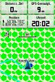
Coordinates reached
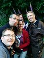
Group shot


Achievements
Mampfred earned the Birthday Geohash Achievement
|