Difference between revisions of "2014-06-16 45 -122"
imported>Michael5000 (→Participants) |
imported>FippeBot m (Location) |
||
| (10 intermediate revisions by one other user not shown) | |||
| Line 2: | Line 2: | ||
<!-- If you did not specify these parameters in the template, please substitute appropriate values for IMAGE, LAT, LON, and DATE (YYYY-MM-DD format) | <!-- If you did not specify these parameters in the template, please substitute appropriate values for IMAGE, LAT, LON, and DATE (YYYY-MM-DD format) | ||
| − | |||
Remove this section if you don't want an image at the top (left) of your report. You should remove the "Image:" or "File:" | Remove this section if you don't want an image at the top (left) of your report. You should remove the "Image:" or "File:" | ||
| Line 18: | Line 17: | ||
__NOTOC__ | __NOTOC__ | ||
== Location == | == Location == | ||
| − | On a steep hillside | + | On a steep hillside off of Highway 14 near Skamania, Washington. |
== Participants == | == Participants == | ||
| − | + | ||
| − | |||
===Expedition 2=== | ===Expedition 2=== | ||
*[[User:Frogman|Frogman]] | *[[User:Frogman|Frogman]] | ||
*Reece | *Reece | ||
| − | == | + | ===Expedition 1=== |
| − | + | *[[User:Michael5000|Michael5000]] | |
== Expedition == | == Expedition == | ||
| + | |||
| + | ===The Frogman's Tale=== | ||
| + | |||
This expedition was pretty uneventful. After stopping for a bite at Taco Bell, we headed over into Washington and down the gorge. There was a truck that certainly should have pulled over on Highway 14 that slowed us down quite a bit, but we ended up making it to the turn-off. The hashpoint itself was a bit down the hill, but we easily got within GPS margin-of-error, so I called it a win. | This expedition was pretty uneventful. After stopping for a bite at Taco Bell, we headed over into Washington and down the gorge. There was a truck that certainly should have pulled over on Highway 14 that slowed us down quite a bit, but we ended up making it to the turn-off. The hashpoint itself was a bit down the hill, but we easily got within GPS margin-of-error, so I called it a win. | ||
We took the scenic drive up the gorge instead of heading back across 205 on our way home. It turns out that the Bridge of the Gods is a toll bridge. If I had known, I might not have taken that route, but it was a pretty drive. | We took the scenic drive up the gorge instead of heading back across 205 on our way home. It turns out that the Bridge of the Gods is a toll bridge. If I had known, I might not have taken that route, but it was a pretty drive. | ||
| − | == | + | ===Michael5000's Tale=== |
| − | + | ||
| + | I took a long lunch and crossed into the state of Washington, then headed east on State Highway 14. I, too, had a slow truck ahead of me on the long hill up to "Cape Horn," a promontory on the Columbia Gorge. | ||
| + | |||
| + | Highway 14 follows the Columbia River on the Washington side, so any road off of it will head steeply up the side of the Gorge. Smith-Cripe Road was steep and curvy, but well-made and with light traffic, so it was easy enough to pull over and walk toward the hashpoint. Technically, the point was a few meters off the roadbed by my GPS, but since that would involve a tremendous plunge downslope and through brambles, cooler heads prevailed. I felt "there." It's a win. | ||
| + | |||
| + | I left a calling card that would, later, be found. | ||
| + | |||
| + | I went back to work. | ||
== Photos == | == Photos == | ||
| − | + | ||
| − | |||
| − | |||
<gallery perrow="5"> | <gallery perrow="5"> | ||
File:2014-06-16 45 -122 grins.JPG | We made it! | File:2014-06-16 45 -122 grins.JPG | We made it! | ||
File:2014-06-16 45 -122 tiger.JPG | My hashscot found a calling card from an earlier geohasher. | File:2014-06-16 45 -122 tiger.JPG | My hashscot found a calling card from an earlier geohasher. | ||
| + | </gallery> | ||
| + | <gallery perrow="5"> | ||
| + | File:2014-06-16 45 -122 M5K.JPG|Adventure. | ||
| + | File:2014-06-16 45 -122 road.JPG|Smith-Cripe Road | ||
| + | File:2014-06-16 45 -122 gorge.JPG|The Columbia River Gorge, from Route 14 | ||
</gallery> | </gallery> | ||
| Line 50: | Line 61: | ||
{{#vardefine:ribbonwidth|800px}} | {{#vardefine:ribbonwidth|800px}} | ||
<!-- Add any achievement ribbons you earned below, or remove this section --> | <!-- Add any achievement ribbons you earned below, or remove this section --> | ||
| + | |||
| + | [[File:2014-06-16 new area.jpg|thumb|left|This Expedition filled in the intersection of Skamania County and the Portland graticule on Michael5000's "stained glass" map.]] | ||
| Line 55: | Line 68: | ||
[[Category:Expeditions with photos]] | [[Category:Expeditions with photos]] | ||
[[Category:Coordinates reached]] | [[Category:Coordinates reached]] | ||
| + | {{location|US|WA|SM}} | ||
Latest revision as of 00:22, 7 August 2019
| Mon 16 Jun 2014 in 45,-122: 45.6048059, -122.1175859 geohashing.info google osm bing/os kml crox |
Location
On a steep hillside off of Highway 14 near Skamania, Washington.
Participants
Expedition 2
- Frogman
- Reece
Expedition 1
Expedition
The Frogman's Tale
This expedition was pretty uneventful. After stopping for a bite at Taco Bell, we headed over into Washington and down the gorge. There was a truck that certainly should have pulled over on Highway 14 that slowed us down quite a bit, but we ended up making it to the turn-off. The hashpoint itself was a bit down the hill, but we easily got within GPS margin-of-error, so I called it a win.
We took the scenic drive up the gorge instead of heading back across 205 on our way home. It turns out that the Bridge of the Gods is a toll bridge. If I had known, I might not have taken that route, but it was a pretty drive.
Michael5000's Tale
I took a long lunch and crossed into the state of Washington, then headed east on State Highway 14. I, too, had a slow truck ahead of me on the long hill up to "Cape Horn," a promontory on the Columbia Gorge.
Highway 14 follows the Columbia River on the Washington side, so any road off of it will head steeply up the side of the Gorge. Smith-Cripe Road was steep and curvy, but well-made and with light traffic, so it was easy enough to pull over and walk toward the hashpoint. Technically, the point was a few meters off the roadbed by my GPS, but since that would involve a tremendous plunge downslope and through brambles, cooler heads prevailed. I felt "there." It's a win.
I left a calling card that would, later, be found.
I went back to work.
Photos

We made it!
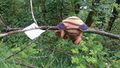
My hashscot found a calling card from an earlier geohasher.


Adventure.
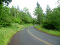
Smith-Cripe Road
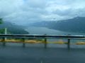
The Columbia River Gorge, from Route 14


