Difference between revisions of "2014-06-18 51 9"
From Geohashing
imported>GeorgDerReisende (create page) |
m (Location correction) |
||
| (4 intermediate revisions by 2 users not shown) | |||
| Line 1: | Line 1: | ||
| − | |||
| − | |||
| − | |||
| − | |||
| − | |||
| − | |||
| − | |||
| − | |||
| − | |||
| − | |||
{{meetup graticule | {{meetup graticule | ||
| lat=51 | | lat=51 | ||
| Line 18: | Line 8: | ||
__NOTOC__ | __NOTOC__ | ||
== Location == | == Location == | ||
| − | + | ||
| + | The hash lay in the fields of Eiterhagen. | ||
== Participants == | == Participants == | ||
| − | + | ||
| − | + | [[User:GeorgDerReisende|GeorgDerReisende]] | |
== Plans == | == Plans == | ||
| − | + | ||
| + | The plan was to hitchhike to there, finding the hash, and travel home. | ||
== Expedition == | == Expedition == | ||
| − | + | ||
| + | I started at home at 14:00, started to hitchhike at 14:45, got a first lift to Fürstenhagen at 15:15 and with a second lift I arrived at Eiterhagen, just below the hash. I walked a little and came near to it. But it was on the field, eight meters away. So I climbed down to the edge of the field, hopefully to reach the five meter mark. And I did it. Afterwards I tried to find some geocaches, but I didn't find any. | ||
== Tracklog == | == Tracklog == | ||
| Line 38: | Line 31: | ||
--> | --> | ||
<gallery perrow="5"> | <gallery perrow="5"> | ||
| + | Image:2014-06-18 51 9 GeorgDerReisende 2129.jpg | proof of 5 meter | ||
| + | Image:2014-06-18 51 9 GeorgDerReisende 2130.jpg | the hash lay 5 meters in the field | ||
| + | Image:2014-06-18 51 9 GeorgDerReisende 2131.jpg | west | ||
| + | Image:2014-06-18 51 9 GeorgDerReisende 2132.jpg | north | ||
| + | Image:2014-06-18 51 9 GeorgDerReisende 2133.jpg | east | ||
| + | Image:2014-06-18 51 9 GeorgDerReisende 2134.jpg | south | ||
| + | Image:2014-06-18 51 9 GeorgDerReisende 2135.jpg | the geohasher | ||
</gallery> | </gallery> | ||
| Line 44: | Line 44: | ||
<!-- Add any achievement ribbons you earned below, or remove this section --> | <!-- Add any achievement ribbons you earned below, or remove this section --> | ||
| + | {{Thumbs Up | latitude = 51 | longitude = 9 | date = 2014-06-18 | name = GeorgDerReisende }} | ||
| − | + | [[Category:Expeditions]] | |
| − | |||
| − | [[Category: | ||
| − | + | [[Category:Expeditions with photos]] | |
| − | |||
| − | |||
| − | |||
| − | |||
| − | |||
| − | |||
| − | |||
| − | |||
| − | |||
| − | |||
| − | |||
| − | |||
| − | |||
| − | |||
[[Category:Coordinates reached]] | [[Category:Coordinates reached]] | ||
| − | + | {{location|DE|HE|KS}} | |
| − | |||
| − | |||
| − | |||
| − | |||
| − | |||
| − | |||
| − | |||
| − | |||
| − | |||
| − | |||
| − | |||
| − | |||
| − | |||
| − | |||
| − | |||
| − | |||
| − | |||
Latest revision as of 20:24, 16 May 2020
| Wed 18 Jun 2014 in 51,9: 51.1873917, 9.5755336 geohashing.info google osm bing/os kml crox |
Location
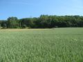
The hash lay in the fields of Eiterhagen.
Participants
Plans
The plan was to hitchhike to there, finding the hash, and travel home.
Expedition
I started at home at 14:00, started to hitchhike at 14:45, got a first lift to Fürstenhagen at 15:15 and with a second lift I arrived at Eiterhagen, just below the hash. I walked a little and came near to it. But it was on the field, eight meters away. So I climbed down to the edge of the field, hopefully to reach the five meter mark. And I did it. Afterwards I tried to find some geocaches, but I didn't find any.
Tracklog
Photos
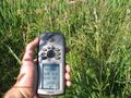
proof of 5 meter
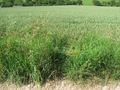
the hash lay 5 meters in the field
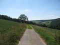
west
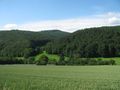
north
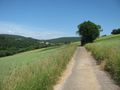
east
south
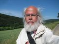
the geohasher


Achievements
GeorgDerReisende earned the Thumbs Up Geohash Achievement
|