Difference between revisions of "2014-06-20 45 -122"
imported>Frogman (→Expedition) |
imported>FippeBot m (Location) |
||
| (10 intermediate revisions by 3 users not shown) | |||
| Line 15: | Line 15: | ||
}} | }} | ||
| − | + | ||
__NOTOC__ | __NOTOC__ | ||
== Location == | == Location == | ||
| Line 21: | Line 21: | ||
== Participants == | == Participants == | ||
| + | |||
| + | Group One | ||
| + | |||
*[[User:Frogman|Frogman]] | *[[User:Frogman|Frogman]] | ||
*Kate | *Kate | ||
*Leah | *Leah | ||
| + | |||
| + | Group Two | ||
| + | * [[User:Jiml|Jim]] | ||
| + | |||
| + | Group 5000 | ||
| + | * [[User:Michael5000|Michael5000]] | ||
== Plans == | == Plans == | ||
| − | + | ||
| + | === Expedition Two=== | ||
| + | |||
| + | Jim looked at the hashpoint this morning and thought "That looks pretty accessible, and feasible to get to" | ||
| + | |||
| + | === Expedition 5000=== | ||
| + | *Michael5000 plans a run-to-hashpoint expedition after work. | ||
== Expedition == | == Expedition == | ||
| + | |||
| + | === Expedition One === | ||
| + | |||
We were shopping in the area so we stopped by this easy hashpoint! It took a while for my GPS to calibrate, so we stood around in the parking lot for a while. People who looked like they had business at the archdiocese passed. No one asked us what we were doing. | We were shopping in the area so we stopped by this easy hashpoint! It took a while for my GPS to calibrate, so we stood around in the parking lot for a while. People who looked like they had business at the archdiocese passed. No one asked us what we were doing. | ||
| − | == | + | === Expedition Two === |
| − | + | Jim took a couple of buses from work and found himself standing a block from the hashpoint. I walked up and examined the | |
| + | sign, which indicated that it was private property, but only that I couldn't use it as a thruway. Since I was planning | ||
| + | on walking out the same entrance I was going into, I walked towards the main entrance, which the street door had | ||
| + | directed me towards. | ||
| + | |||
| + | Most the the way there, my GPS reported that we had arrived at the hashpoint, and I attempted to take a photo in the | ||
| + | glare. I then went in search of a bus and two trains to find my way home. | ||
| + | |||
| + | |||
| + | === Expedition Five Thousand === | ||
| + | |||
| + | This parking lot is about a kilometer from home, and we occasionally use it as a shortcut when we walk to the nearby theater and restaurants. I ran to the hashpoint, and to an ATM, and it still managed to be one of the shortest runs of the year. | ||
== Photos == | == Photos == | ||
| − | < | + | |
| − | + | === Expedition One === | |
| − | --> | + | |
| + | <gallery perrow="5"> | ||
| + | File:2014-06-20 45 -122 art.jpg | A bit of art near the hashpoint! | ||
| + | File:2014-06-20 45 -122 grins.jpg | Grins! | ||
| + | File:2014-06-20 45 -122 archdiocese.jpg | The hashpoint is below this sign. | ||
| + | </gallery> | ||
| + | |||
| + | === Expedition Five Thousand === | ||
| + | |||
<gallery perrow="5"> | <gallery perrow="5"> | ||
| + | File:2014-06-20 45 -122 m5k.JPG|So many ways to fail the grin | ||
| + | File:2014-06-20 45 -122 archbishop.JPG|The hashpoint was only a few meters from the Archbishop's parking space. | ||
</gallery> | </gallery> | ||
== Achievements == | == Achievements == | ||
{{#vardefine:ribbonwidth|800px}} | {{#vardefine:ribbonwidth|800px}} | ||
| − | |||
| + | {{Land geohash | ||
| + | | latitude = 45 | ||
| + | | longitude = -122 | ||
| + | | date = 2014-06-20 | ||
| + | | name = [[User:Frogman|Frogman]], Kate, Leah, [[User:Jiml|Jim]], [[User:Michael5000|Michael5000]] | ||
| + | }} | ||
| − | + | {{Public transport geohash | |
| − | + | | latitude = 45 | |
| − | [[ | + | | longitude = -122 |
| + | | date = 2014-06-20 | ||
| + | | name = [[User:Jiml|Jim]] | ||
| + | }} | ||
| + | |||
| + | {{Walk geohash | ||
| + | | latitude = 45 | ||
| + | | longitude = -122 | ||
| + | | date = 2014-06-20 | ||
| + | | name = [[User:Michael5000|Michael5000]] | ||
| + | }} | ||
| − | |||
| − | |||
| − | |||
| − | |||
| − | |||
| − | |||
[[Category:Expeditions]] | [[Category:Expeditions]] | ||
| − | |||
[[Category:Expeditions with photos]] | [[Category:Expeditions with photos]] | ||
| − | |||
| − | |||
| − | |||
| − | |||
| − | |||
[[Category:Coordinates reached]] | [[Category:Coordinates reached]] | ||
| − | + | {{location|US|OR|MU}} | |
| − | |||
| − | |||
| − | |||
| − | |||
| − | |||
| − | |||
| − | |||
| − | |||
| − | |||
| − | |||
| − | |||
| − | |||
| − | |||
| − | |||
| − | |||
| − | |||
| − | |||
Latest revision as of 06:57, 14 August 2019
| Fri 20 Jun 2014 in 45,-122: 45.5225396, -122.6362660 geohashing.info google osm bing/os kml crox |
Location
In the parking lot of the Archdiocese of Portland in Oregon.
Participants
Group One
- Frogman
- Kate
- Leah
Group Two
Group 5000
Plans
Expedition Two
Jim looked at the hashpoint this morning and thought "That looks pretty accessible, and feasible to get to"
Expedition 5000
- Michael5000 plans a run-to-hashpoint expedition after work.
Expedition
Expedition One
We were shopping in the area so we stopped by this easy hashpoint! It took a while for my GPS to calibrate, so we stood around in the parking lot for a while. People who looked like they had business at the archdiocese passed. No one asked us what we were doing.
Expedition Two
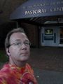
Jim took a couple of buses from work and found himself standing a block from the hashpoint. I walked up and examined the sign, which indicated that it was private property, but only that I couldn't use it as a thruway. Since I was planning on walking out the same entrance I was going into, I walked towards the main entrance, which the street door had directed me towards.
Most the the way there, my GPS reported that we had arrived at the hashpoint, and I attempted to take a photo in the glare. I then went in search of a bus and two trains to find my way home.
Expedition Five Thousand
This parking lot is about a kilometer from home, and we occasionally use it as a shortcut when we walk to the nearby theater and restaurants. I ran to the hashpoint, and to an ATM, and it still managed to be one of the shortest runs of the year.
Photos
Expedition One

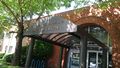
A bit of art near the hashpoint!

Grins!
The hashpoint is below this sign.


Expedition Five Thousand
So many ways to fail the grin

The hashpoint was only a few meters from the Archbishop's parking space.


Achievements
Frogman, Kate, Leah, Jim, Michael5000 earned the Land geohash achievement
|
Jim earned the Public transport geohash achievement
|
Michael5000 earned the Walk geohash Achievement
|