Difference between revisions of "2014-06-29 47 -122"
From Geohashing
imported>Thomcat ([live picture] Pier 15 1/2 [http://www.openstreetmap.org/?lat=47.58720000&lon=-122.35200000&zoom=16&layers=B000FTF @47.5872,-122.3520]) |
imported>Thomcat (Success, expedition story pending) |
||
| Line 1: | Line 1: | ||
| − | |||
| − | |||
| − | |||
| − | |||
| − | |||
| − | |||
| − | |||
| − | |||
| − | |||
| − | |||
{{meetup graticule | {{meetup graticule | ||
| lat=47 | | lat=47 | ||
| lon=-122 | | lon=-122 | ||
| date=2014-06-29 | | date=2014-06-29 | ||
| + | | graticule_name=Seattle | ||
| + | | graticule_link=Seattle, Washington | ||
}} | }} | ||
| Line 22: | Line 14: | ||
== Participants == | == Participants == | ||
| − | + | * [[User:OtherJack|OtherJack]] | |
| − | + | * [[User:Thomcat|Thomcat]] | |
| − | [[User: | ||
| − | |||
== Plans == | == Plans == | ||
<!-- what were the original plans --> | <!-- what were the original plans --> | ||
Bike there, arrive 4pm, take pictures of cranes! I'm fine with other times too, so let me know if a different schedule works better for you... | Bike there, arrive 4pm, take pictures of cranes! I'm fine with other times too, so let me know if a different schedule works better for you... | ||
:Slight change of plans, I'm now aiming for 2:30 or 3pm, not 4. Doesn't seem like anyone will be inconvenienced... -- [[User:OtherJack|OtherJack]] ([[User talk:OtherJack|talk]]) 16:08, 29 June 2014 (EDT) | :Slight change of plans, I'm now aiming for 2:30 or 3pm, not 4. Doesn't seem like anyone will be inconvenienced... -- [[User:OtherJack|OtherJack]] ([[User talk:OtherJack|talk]]) 16:08, 29 June 2014 (EDT) | ||
| + | ::Unannounced plans - drop by on the way home from baseball, simultaneously avoiding road work on I-5 N and a Gay Pride parade downtown. --[[User:Thomcat|Thomcat]] ([[User talk:Thomcat|talk]]) 17:59, 29 June 2014 (EDT) | ||
== Expedition == | == Expedition == | ||
| − | + | ||
| + | ===Thomcat=== | ||
| + | |||
| + | |||
== Photos == | == Photos == | ||
| Line 43: | Line 37: | ||
Image:2014-06-29_47_-122_thomcat_1404075964549.jpg | [http://www.openstreetmap.org/?lat=47.58088999&lon=-122.34981661&zoom=16&layers=B000FTF @47.5809,-122.3498] | Image:2014-06-29_47_-122_thomcat_1404075964549.jpg | [http://www.openstreetmap.org/?lat=47.58088999&lon=-122.34981661&zoom=16&layers=B000FTF @47.5809,-122.3498] | ||
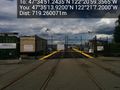
| − | Image:2014-06-29_47_-122_thomcat_1404076161307.jpg | View | + | Image:2014-06-29_47_-122_thomcat_1404076161307.jpg | View north (the Space Needle) [http://www.openstreetmap.org/?lat=47.58090000&lon=-122.35000000&zoom=16&layers=B000FTF @47.5809,-122.3500] |
Image:2014-06-29_47_-122_thomcat_1404076170913.jpg | View west [http://www.openstreetmap.org/?lat=47.58090000&lon=-122.35000000&zoom=16&layers=B000FTF @47.5809,-122.3500] | Image:2014-06-29_47_-122_thomcat_1404076170913.jpg | View west [http://www.openstreetmap.org/?lat=47.58090000&lon=-122.35000000&zoom=16&layers=B000FTF @47.5809,-122.3500] | ||
| Line 49: | Line 43: | ||
Image:2014-06-29_47_-122_thomcat_1404076176750.jpg | View south [http://www.openstreetmap.org/?lat=47.58090000&lon=-122.35000000&zoom=16&layers=B000FTF @47.5809,-122.3500] | Image:2014-06-29_47_-122_thomcat_1404076176750.jpg | View south [http://www.openstreetmap.org/?lat=47.58090000&lon=-122.35000000&zoom=16&layers=B000FTF @47.5809,-122.3500] | ||
| − | Image:2014-06-29_47_-122_thomcat_1404076182305.jpg | | + | Image:2014-06-29_47_-122_thomcat_1404076182305.jpg | View east [http://www.openstreetmap.org/?lat=47.58090000&lon=-122.35000000&zoom=16&layers=B000FTF @47.5809,-122.3500] |
Image:2014-06-29_47_-122_thomcat_1404076817007.jpg | Pier 15 1/2 [http://www.openstreetmap.org/?lat=47.58720000&lon=-122.35200000&zoom=16&layers=B000FTF @47.5872,-122.3520] | Image:2014-06-29_47_-122_thomcat_1404076817007.jpg | Pier 15 1/2 [http://www.openstreetmap.org/?lat=47.58720000&lon=-122.35200000&zoom=16&layers=B000FTF @47.5872,-122.3520] | ||
| Line 58: | Line 52: | ||
<!-- Add any achievement ribbons you earned below, or remove this section --> | <!-- Add any achievement ribbons you earned below, or remove this section --> | ||
| − | + | [[Category:Expeditions]] | |
| − | + | [[Category:Expeditions with photos]] | |
| − | [[Category: | + | [[Category:Coordinates reached]] |
Revision as of 21:59, 29 June 2014
| Sun 29 Jun 2014 in Seattle: 47.5809010, -122.3498212 geohashing.info google osm bing/os kml crox |
Location
In a public-looking roadway in the Port of Seattle!
Participants
Plans
Bike there, arrive 4pm, take pictures of cranes! I'm fine with other times too, so let me know if a different schedule works better for you...
- Slight change of plans, I'm now aiming for 2:30 or 3pm, not 4. Doesn't seem like anyone will be inconvenienced... -- OtherJack (talk) 16:08, 29 June 2014 (EDT)
Expedition
Thomcat
Photos
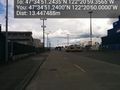
View north (the Space Needle) @47.5809,-122.3500
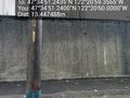
View west @47.5809,-122.3500
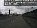
View south @47.5809,-122.3500
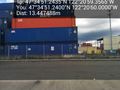
View east @47.5809,-122.3500
Pier 15 1/2 @47.5872,-122.3520


