Difference between revisions of "2014-06-29 47 -122"
imported>OtherJack ([live picture] Made it! Saw Thoms mark too, and the sun's out) |
imported>Thomcat |
||
| Line 10: | Line 10: | ||
__NOTOC__ | __NOTOC__ | ||
== Location == | == Location == | ||
| − | |||
In a public-looking roadway in the Port of Seattle! | In a public-looking roadway in the Port of Seattle! | ||
| Line 26: | Line 25: | ||
===Thomcat=== | ===Thomcat=== | ||
| + | Another day, another geohash. We've had a run of remote or non-accessible points here in Seattle, so when two showed up this weekend, I smiled... and promptly forgot all about the wiki. To be fair, I've been busy. | ||
| + | Another day, another baseball game, another chance to stop on the way home. As Jack pointed out above, this looked pretty public, and I needed to take an alternate route home - one of two floating bridges was closed and roadwork severely limited traffic on I-5 northbound. Alternate route - slightly south to Harbor Island and then North along Highway 99. | ||
| + | |||
| + | [http://en.wikipedia.org/wiki/Harbor_Island_(Seattle) Harbor Island] is man-made, completed in 1909 and (at that time) the largest artificial island (350 acres). During the earthquake of April 13, 1949, parts of the island rose as much as 16 inches and other parts dropped 12 inches. | ||
| + | |||
| + | Upon reaching the island, two roadways were evident - one leading to a railroad spanning bridge, the other running alongside the tracks. Which would prove the best bet? I took the high road to try and find out. | ||
| + | |||
| + | This road led to a road on the outside of the tracks - I wanted to be on the inside. Fortunately, towards the north end of the island was a crossover point. I took this and reached the right road with ease. Plenty of parking, so I reached the approximate north/south and pulled to the curb. | ||
| + | |||
| + | The distinct waft of petrochemicals assailed my nose - whether from the giant tanks nearby or the boats not much further away I never found out. Later research indicated that Bulk Petroleum Storage is done on the island - but anything I can smell isn't really being stored, no? | ||
| + | |||
| + | The geohash point was easily found, and after a small dance I chalked an X. I followed up with a giant XKCD on the wall and another on the pole, then photographed the cardinal directions. Lined up with this road was our iconic Space Needle, not quite visible in the very small photo uploaded below. ''I will upload another tomorrow.'' Interesting point there - Jack and I have slightly different versions of GeoHash Droid I think - mine appears to have the "sight impaired" setting. | ||
| + | |||
| + | Leaving, I swung as far north as possible on the island, reaching the interestingly named Pier 15½. No train to Hogwarts was evident, however. From here I took the low road and raced a train to the south end of the island (the train about 5 mph, my Prius slightly faster), then home. | ||
| + | |||
| + | === OtherJack === | ||
| Line 45: | Line 60: | ||
Image:2014-06-29_47_-122_thomcat_1404076182305.jpg | View east [http://www.openstreetmap.org/?lat=47.58090000&lon=-122.35000000&zoom=16&layers=B000FTF @47.5809,-122.3500] | Image:2014-06-29_47_-122_thomcat_1404076182305.jpg | View east [http://www.openstreetmap.org/?lat=47.58090000&lon=-122.35000000&zoom=16&layers=B000FTF @47.5809,-122.3500] | ||
| − | Image:2014-06-29_47_-122_thomcat_1404076817007.jpg | Pier | + | Image:2014-06-29_47_-122_thomcat_1404076817007.jpg | Pier 15½ [http://www.openstreetmap.org/?lat=47.58720000&lon=-122.35200000&zoom=16&layers=B000FTF @47.5872,-122.3520] |
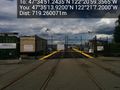
| − | Image:2014-06-29_47_-122_OtherJack_1404080775036.jpg | Made it! Saw | + | Image:2014-06-29_47_-122_OtherJack_1404080775036.jpg | Made it! Saw Thom's mark too, and the sun's out |
</gallery> | </gallery> | ||
Revision as of 05:48, 30 June 2014
| Sun 29 Jun 2014 in Seattle: 47.5809010, -122.3498212 geohashing.info google osm bing/os kml crox |
Location
In a public-looking roadway in the Port of Seattle!
Participants
Plans
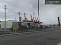
Bike there, arrive 4pm, take pictures of cranes! I'm fine with other times too, so let me know if a different schedule works better for you...
- Slight change of plans, I'm now aiming for 2:30 or 3pm, not 4. Doesn't seem like anyone will be inconvenienced... -- OtherJack (talk) 16:08, 29 June 2014 (EDT)
Expedition
Thomcat
Another day, another geohash. We've had a run of remote or non-accessible points here in Seattle, so when two showed up this weekend, I smiled... and promptly forgot all about the wiki. To be fair, I've been busy.
Another day, another baseball game, another chance to stop on the way home. As Jack pointed out above, this looked pretty public, and I needed to take an alternate route home - one of two floating bridges was closed and roadwork severely limited traffic on I-5 northbound. Alternate route - slightly south to Harbor Island and then North along Highway 99.
Harbor Island is man-made, completed in 1909 and (at that time) the largest artificial island (350 acres). During the earthquake of April 13, 1949, parts of the island rose as much as 16 inches and other parts dropped 12 inches.
Upon reaching the island, two roadways were evident - one leading to a railroad spanning bridge, the other running alongside the tracks. Which would prove the best bet? I took the high road to try and find out.
This road led to a road on the outside of the tracks - I wanted to be on the inside. Fortunately, towards the north end of the island was a crossover point. I took this and reached the right road with ease. Plenty of parking, so I reached the approximate north/south and pulled to the curb.
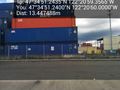
The distinct waft of petrochemicals assailed my nose - whether from the giant tanks nearby or the boats not much further away I never found out. Later research indicated that Bulk Petroleum Storage is done on the island - but anything I can smell isn't really being stored, no?
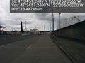
The geohash point was easily found, and after a small dance I chalked an X. I followed up with a giant XKCD on the wall and another on the pole, then photographed the cardinal directions. Lined up with this road was our iconic Space Needle, not quite visible in the very small photo uploaded below. I will upload another tomorrow. Interesting point there - Jack and I have slightly different versions of GeoHash Droid I think - mine appears to have the "sight impaired" setting.
Leaving, I swung as far north as possible on the island, reaching the interestingly named Pier 15½. No train to Hogwarts was evident, however. From here I took the low road and raced a train to the south end of the island (the train about 5 mph, my Prius slightly faster), then home.
OtherJack
Photos
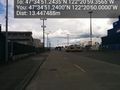
View north (the Space Needle) @47.5809,-122.3500
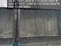
View west @47.5809,-122.3500
View south @47.5809,-122.3500
View east @47.5809,-122.3500
Pier 15½ @47.5872,-122.3520
Made it! Saw Thom's mark too, and the sun's out


