Difference between revisions of "2014-06-29 47 -122"
imported>OtherJack (→Plans) |
imported>FippeBot m (Location) |
||
| (12 intermediate revisions by 2 users not shown) | |||
| Line 1: | Line 1: | ||
| − | |||
| − | |||
| − | |||
| − | |||
| − | |||
| − | |||
| − | |||
| − | |||
| − | |||
| − | |||
{{meetup graticule | {{meetup graticule | ||
| lat=47 | | lat=47 | ||
| lon=-122 | | lon=-122 | ||
| date=2014-06-29 | | date=2014-06-29 | ||
| + | | graticule_name=Seattle | ||
| + | | graticule_link=Seattle, Washington | ||
}} | }} | ||
| Line 18: | Line 10: | ||
__NOTOC__ | __NOTOC__ | ||
== Location == | == Location == | ||
| − | |||
In a public-looking roadway in the Port of Seattle! | In a public-looking roadway in the Port of Seattle! | ||
== Participants == | == Participants == | ||
| − | + | * [[User:OtherJack|OtherJack]] | |
| − | + | * [[User:Thomcat|Thomcat]] | |
| − | [[User: | ||
| − | |||
== Plans == | == Plans == | ||
<!-- what were the original plans --> | <!-- what were the original plans --> | ||
Bike there, arrive 4pm, take pictures of cranes! I'm fine with other times too, so let me know if a different schedule works better for you... | Bike there, arrive 4pm, take pictures of cranes! I'm fine with other times too, so let me know if a different schedule works better for you... | ||
:Slight change of plans, I'm now aiming for 2:30 or 3pm, not 4. Doesn't seem like anyone will be inconvenienced... -- [[User:OtherJack|OtherJack]] ([[User talk:OtherJack|talk]]) 16:08, 29 June 2014 (EDT) | :Slight change of plans, I'm now aiming for 2:30 or 3pm, not 4. Doesn't seem like anyone will be inconvenienced... -- [[User:OtherJack|OtherJack]] ([[User talk:OtherJack|talk]]) 16:08, 29 June 2014 (EDT) | ||
| + | ::Unannounced plans - drop by on the way home from baseball, simultaneously avoiding road work on I-5 N and a Gay Pride parade downtown. --[[User:Thomcat|Thomcat]] ([[User talk:Thomcat|talk]]) 17:59, 29 June 2014 (EDT) | ||
== Expedition == | == Expedition == | ||
| − | + | ||
| + | ===Thomcat=== | ||
| + | Another day, another geohash. We've had a run of remote or non-accessible points here in Seattle, so when two showed up this weekend, I smiled... and promptly forgot all about the wiki. To be fair, I've been busy. | ||
| + | |||
| + | Another day, another baseball game, another chance to stop on the way home. As Jack pointed out above, this looked pretty public, and I needed to take an alternate route home - one of two floating bridges was closed and roadwork severely limited traffic on I-5 northbound. Alternate route - slightly south to Harbor Island and then North along Highway 99. | ||
| + | |||
| + | [http://en.wikipedia.org/wiki/Harbor_Island_(Seattle) Harbor Island] is man-made, completed in 1909 and (at that time) the largest artificial island (350 acres). During the earthquake of April 13, 1949, parts of the island rose as much as 16 inches and other parts dropped 12 inches. | ||
| + | |||
| + | Upon reaching the island, two roadways were evident - one leading to a railroad spanning bridge, the other running alongside the tracks. Which would prove the best bet? I took the high road to try and find out. | ||
| + | |||
| + | This road led to a road on the outside of the tracks - I wanted to be on the inside. Fortunately, towards the north end of the island was a crossover point. I took this and reached the right road with ease. Plenty of parking, so I reached the approximate north/south and pulled to the curb. | ||
| + | |||
| + | The distinct waft of petrochemicals assailed my nose - whether from the giant tanks nearby or the boats not much further away I never found out. Later research indicated that Bulk Petroleum Storage is done on the island - but anything I can smell isn't really being stored, no? | ||
| + | |||
| + | The geohash point was easily found, and after a small dance I chalked an X. I followed up with a giant XKCD on the wall and another on the pole, then photographed the cardinal directions. Lined up with this road was our iconic Space Needle, not quite visible in the very small photo uploaded below. ''I will upload another tomorrow.'' Interesting point there - Jack and I have slightly different versions of GeoHash Droid I think - mine appears to have the "sight impaired" setting. | ||
| + | |||
| + | Leaving, I swung as far north as possible on the island, reaching the interestingly named Pier 15½. No train to Hogwarts was evident, however. From here I took the low road and raced a train to the south end of the island (the train about 5 mph, my Prius slightly faster), then home. | ||
| + | |||
| + | === OtherJack === | ||
| + | |||
| + | Left on the late side so I didn't get there until 3:15, something like an hour after Thomcat. The weather was much nicer than he warned me though - sunny with interesting clouds (pictured below.) And I didn't notice any particularly strong petrochemical smell. My nose is a little stuffed though, so that may explain it. I also appreciated that the space needle lined up so well with the hashroad - and you can see it in my pictures! Really cool hashpoint. | ||
| + | |||
| + | Unfortunately, on the way back I struck something while crossing one of the little exits off Spokane St. and fell from my bike, internally bruising the outside of my left hand pretty bad. Maybe it was a curb I didn't realize I was going over. In any case, I am currently trying to write up my PhD dissertation by a deadline, and I hoped this wasn't going to make typing too painful! Luckily, with ice back at the office it mostly subsided after a few hours. Still some lingering soreness though... | ||
== Photos == | == Photos == | ||
| Line 39: | Line 51: | ||
Image:2012-##-## ## ## Alpha.jpg | Witty Comment | Image:2012-##-## ## ## Alpha.jpg | Witty Comment | ||
--> | --> | ||
| + | ===Thomcat=== | ||
| + | |||
| + | <gallery perrow="5"> | ||
| + | Image:2014-06-29_47_-122_thomcat_1404075964549.jpg | [http://www.openstreetmap.org/?lat=47.58088999&lon=-122.34981661&zoom=16&layers=B000FTF @47.5809,-122.3498] | ||
| + | |||
| + | Image:2014-06-29_47_-122_thomcat_1404076161307.jpg | View north (the Space Needle) [http://www.openstreetmap.org/?lat=47.58090000&lon=-122.35000000&zoom=16&layers=B000FTF @47.5809,-122.3500] | ||
| + | |||
| + | Image:2014-06-29_47_-122_thomcat_1404076170913.jpg | View west [http://www.openstreetmap.org/?lat=47.58090000&lon=-122.35000000&zoom=16&layers=B000FTF @47.5809,-122.3500] | ||
| + | |||
| + | Image:2014-06-29_47_-122_thomcat_1404076176750.jpg | View south [http://www.openstreetmap.org/?lat=47.58090000&lon=-122.35000000&zoom=16&layers=B000FTF @47.5809,-122.3500] | ||
| + | |||
| + | Image:2014-06-29_47_-122_thomcat_1404076182305.jpg | View east [http://www.openstreetmap.org/?lat=47.58090000&lon=-122.35000000&zoom=16&layers=B000FTF @47.5809,-122.3500] | ||
| + | |||
| + | Image:2014-06-29_47_-122_thomcat_1404076817007.jpg | Pier 15½ [http://www.openstreetmap.org/?lat=47.58720000&lon=-122.35200000&zoom=16&layers=B000FTF @47.5872,-122.3520] | ||
| + | </gallery> | ||
| + | |||
| + | ===OtherJack=== | ||
| + | |||
<gallery perrow="5"> | <gallery perrow="5"> | ||
| + | Image:2014-06-29_47_-122_OtherJack_1404080775036.jpg | Made it! Saw Thom's mark too, and the sun's out | ||
| + | Image:2014-06-29 15.18.42.jpg | Took some cloud/crane shots waiting for the GPS to rev up | ||
| + | Image:2014-06-29 15.23.15.jpg | Nailed it again! | ||
| + | Image:2014-06-29 15.26.00.jpg | Took me a strangely long time to notice this... :> | ||
| + | Image:2014-06-29 15.26.06.jpg | Steed | ||
| + | Image:2014-06-29 15.26.24.jpg | ||
| + | Image:2014-06-29 15.26.46.jpg | Back towards the Space Needle (looks like another light pole in this grainy picture, sorry) | ||
| + | Image:2014-06-29 15.31.29.jpg | ||
| + | Image:2014-06-29 15.38.03.jpg | More cranes and clouds | ||
| + | Image:2014-06-29 15.38.22.jpg | A train potentially resembling the one Thom raced | ||
</gallery> | </gallery> | ||
| Line 45: | Line 85: | ||
{{#vardefine:ribbonwidth|800px}} | {{#vardefine:ribbonwidth|800px}} | ||
<!-- Add any achievement ribbons you earned below, or remove this section --> | <!-- Add any achievement ribbons you earned below, or remove this section --> | ||
| − | + | {{Bicycle geohash | latitude = 47 | longitude = -122 | date = 2014-06-29 | name = [[User:OtherJack|OtherJack]] | distance = about 16km (each way)}} | |
| − | + | (my first bike hash for almost 3 months! How did this lapse occur?) | |
| − | + | [[Category:Expeditions]] | |
| − | [[Category: | + | [[Category:Expeditions with photos]] |
| + | [[Category:Coordinates reached]] | ||
| + | {{location|US|WA|KN}} | ||
Latest revision as of 00:35, 15 August 2019
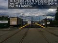
| Sun 29 Jun 2014 in Seattle: 47.5809010, -122.3498212 geohashing.info google osm bing/os kml crox |
Location
In a public-looking roadway in the Port of Seattle!
Participants
Plans
Bike there, arrive 4pm, take pictures of cranes! I'm fine with other times too, so let me know if a different schedule works better for you...
- Slight change of plans, I'm now aiming for 2:30 or 3pm, not 4. Doesn't seem like anyone will be inconvenienced... -- OtherJack (talk) 16:08, 29 June 2014 (EDT)
Expedition
Thomcat
Another day, another geohash. We've had a run of remote or non-accessible points here in Seattle, so when two showed up this weekend, I smiled... and promptly forgot all about the wiki. To be fair, I've been busy.
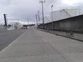
Another day, another baseball game, another chance to stop on the way home. As Jack pointed out above, this looked pretty public, and I needed to take an alternate route home - one of two floating bridges was closed and roadwork severely limited traffic on I-5 northbound. Alternate route - slightly south to Harbor Island and then North along Highway 99.
Harbor Island is man-made, completed in 1909 and (at that time) the largest artificial island (350 acres). During the earthquake of April 13, 1949, parts of the island rose as much as 16 inches and other parts dropped 12 inches.
Upon reaching the island, two roadways were evident - one leading to a railroad spanning bridge, the other running alongside the tracks. Which would prove the best bet? I took the high road to try and find out.
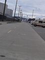
This road led to a road on the outside of the tracks - I wanted to be on the inside. Fortunately, towards the north end of the island was a crossover point. I took this and reached the right road with ease. Plenty of parking, so I reached the approximate north/south and pulled to the curb.
The distinct waft of petrochemicals assailed my nose - whether from the giant tanks nearby or the boats not much further away I never found out. Later research indicated that Bulk Petroleum Storage is done on the island - but anything I can smell isn't really being stored, no?
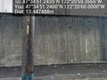
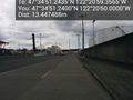
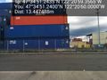
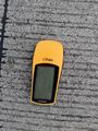
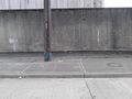
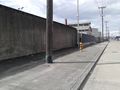
The geohash point was easily found, and after a small dance I chalked an X. I followed up with a giant XKCD on the wall and another on the pole, then photographed the cardinal directions. Lined up with this road was our iconic Space Needle, not quite visible in the very small photo uploaded below. I will upload another tomorrow. Interesting point there - Jack and I have slightly different versions of GeoHash Droid I think - mine appears to have the "sight impaired" setting.
Leaving, I swung as far north as possible on the island, reaching the interestingly named Pier 15½. No train to Hogwarts was evident, however. From here I took the low road and raced a train to the south end of the island (the train about 5 mph, my Prius slightly faster), then home.
OtherJack
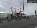
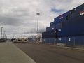
Left on the late side so I didn't get there until 3:15, something like an hour after Thomcat. The weather was much nicer than he warned me though - sunny with interesting clouds (pictured below.) And I didn't notice any particularly strong petrochemical smell. My nose is a little stuffed though, so that may explain it. I also appreciated that the space needle lined up so well with the hashroad - and you can see it in my pictures! Really cool hashpoint.
Unfortunately, on the way back I struck something while crossing one of the little exits off Spokane St. and fell from my bike, internally bruising the outside of my left hand pretty bad. Maybe it was a curb I didn't realize I was going over. In any case, I am currently trying to write up my PhD dissertation by a deadline, and I hoped this wasn't going to make typing too painful! Luckily, with ice back at the office it mostly subsided after a few hours. Still some lingering soreness though...
Photos
Thomcat
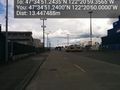
View north (the Space Needle) @47.5809,-122.3500
View west @47.5809,-122.3500
View south @47.5809,-122.3500
View east @47.5809,-122.3500
Pier 15½ @47.5872,-122.3520


OtherJack
Made it! Saw Thom's mark too, and the sun's out
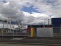
Took some cloud/crane shots waiting for the GPS to rev up
Nailed it again!
Took me a strangely long time to notice this... :>
Steed
Back towards the Space Needle (looks like another light pole in this grainy picture, sorry)
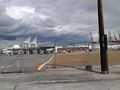
More cranes and clouds
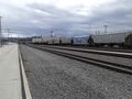
A train potentially resembling the one Thom raced


Achievements
OtherJack earned the Bicycle geohash achievement
|
(my first bike hash for almost 3 months! How did this lapse occur?)