Difference between revisions of "2014-06-29 52 0"
imported>Sourcerer m (→Participants) |
imported>Sourcerer m (→Achievements) |
||
| Line 44: | Line 44: | ||
<!-- Add any achievement ribbons you earned below, or remove this section --> | <!-- Add any achievement ribbons you earned below, or remove this section --> | ||
| − | + | {{Midnight geohash | |
| − | + | | latitude = 52 | |
| − | + | | longitude = 0 | |
| + | | date = 2014-06-29 | ||
| + | | name = Sourcerer | ||
| + | }} | ||
<!-- Potential categories. Please include all the ones appropriate to your expedition --> | <!-- Potential categories. Please include all the ones appropriate to your expedition --> | ||
| − | |||
| − | |||
| − | |||
| − | |||
[[Category:Expeditions]] | [[Category:Expeditions]] | ||
| − | |||
[[Category:Expeditions with photos]] | [[Category:Expeditions with photos]] | ||
| − | |||
| − | |||
| − | |||
| − | |||
| − | |||
[[Category:Coordinates reached]] | [[Category:Coordinates reached]] | ||
| − | |||
| − | |||
| − | |||
| − | |||
| − | |||
| − | |||
| − | |||
| − | |||
| − | |||
| − | |||
| − | |||
| − | |||
| − | |||
| − | |||
| − | |||
| − | |||
| − | |||
| − | |||
Revision as of 01:20, 29 June 2014
| Sun 29 Jun 2014 in 52,0: 52.5809010, 0.3498212 geohashing.info google osm bing/os kml crox |
Location
In the middle of Sluice Road, between the River Great Ouse and the village of Denver, a couple of miles from Downham Market.
Participants
- PaintedJaguar (talk)
- MrsPaintedJaguar
- Sourcerer
Plans
The initial plans are fluid, depending on the weather nearer the time, since various current weather forecasts are suggesting different and seemingly almost random amounts of rain for the day.
If the day looks dry(-ish), PaintedJaguar and MrsPaintedJaguar will aim to walk 12 miles on the Fen Rivers Way, alongside the River Great Ouse, from Littleport train station to Downham Market station, making a small detour to visit the hashpoint near Denver Sluice. Other commitments on Sunday morning would mean a slightly later start than would be ideal for such a walk, probably reaching the hashpoint between 6pm and 7pm in the evening.
If the day looks wet(-ish), they will instead travel direct to Downham Market station, and walk the much shorter 2 miles or so to the hashpoint. The exact timings would then be planned around the weather!
If the day looks very wet, the trip may well be abandoned completely!
Expedition
- Arrived. -- Sourcerer (talk) @52.5808,.3497 00:00, 29 June 2014 (BST).
I timed my journey to arrive at midnight and succeeded. I had not checked the expedition page to see if there were any plans so arriving first was a pure accident. The hashpoint was right on the road and I got to within 1 foot while heading east. There was no possibility of a speed racer award. The narrow lane had a 60mph speed limit but 30mph was my safe limit for the conditions. The hashpoint was of little interest but Denver Sluice is really close and well worth a visit.
Tracklog
Photos
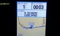
@52.5809,.3497 Sourcerer's Proof

Achievements
Sourcerer earned the Midnight Geohash achievement
|