Difference between revisions of "2014-07-07 -36 149"
imported>Lachie (Created page with " <!-- If you did not specify these parameters in the template, please substitute appropriate values for IMAGE, LAT, LON, and DATE (YYYY-MM-DD format) --> {{meetup graticule...") |
m (More specific location) |
||
| (5 intermediate revisions by 3 users not shown) | |||
| Line 28: | Line 28: | ||
After taking some photos I rode home arrive back at 6:15pm | After taking some photos I rode home arrive back at 6:15pm | ||
| + | |||
| + | |||
| + | Route is here http://www.gpsies.com/map.do?fileId=pmqxujildwsyjxiq | ||
== Photos == | == Photos == | ||
| Line 49: | Line 52: | ||
<!-- Add any achievement ribbons you earned below, or remove this section --> | <!-- Add any achievement ribbons you earned below, or remove this section --> | ||
| + | {{OpenStreetMap achievement | ||
| + | | latitude = -36 | ||
| + | | longitude = 149 | ||
| + | | date = 2014-07-07 | ||
| + | | OSMlink = 24153479 | ||
| + | | name = [[User:Lachie|Lachie]] | ||
| + | }} | ||
| + | |||
| + | {{bicycle geohash | ||
| + | | latitude = -36 | ||
| + | | longitude = 149 | ||
| + | | date = 2014-07-07 | ||
| + | | name = [[User:Lachie|Lachie]] | ||
| + | | distance = 32 | ||
| + | | bothways = true (optional) | ||
| + | }} | ||
<!-- =============== USEFUL CATEGORIES FOLLOW ================ | <!-- =============== USEFUL CATEGORIES FOLLOW ================ | ||
Delete the next line ONLY if you have chosen the appropriate categories below. If you are unsure, don't worry. People will read your report and help you with the classification. --> | Delete the next line ONLY if you have chosen the appropriate categories below. If you are unsure, don't worry. People will read your report and help you with the classification. --> | ||
| Line 55: | Line 74: | ||
[[Category:Expeditions with photos]] | [[Category:Expeditions with photos]] | ||
[[Category:Coordinates reached]] | [[Category:Coordinates reached]] | ||
| + | {{location|AU|NSW|BV}} | ||
Latest revision as of 12:42, 1 August 2020
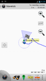
| Mon 7 Jul 2014 in -36,149: -36.9539221, 149.5313055 geohashing.info google osm bing/os kml crox |
Location
Cemetery Road, Rocky Hall
Participants
Expedition
I was staying with relatives on the family block of land near Burragate, NSW where I used to live. The area is a mix mainly of farm land, State Forests and National Parks, typically in small chunks so you'll go through several of each in a trip. I checked the geohash on Saturday and as it was only 12.5 crowKs away I decided to go for it. I discussed the trip with my uncle who knows locals to see if he knew who owned the land, he knew a few of their neighbours but not the owners of that land.
After a morning cutting firewood with an awesome, automatic log splitter I began the 16.5k ride to rocky hall on my trusty mountain bike. The first 3k were on our land/our neighbour's and were pretty rough and had some decent ruts and pot holes, I had crashed on this road 3 days earlier by putting my front wheel in a large pot hole while riding at night. The next leg of the trip was from Burragate to Rocky Hall. A trip I'd done hundreds of times before as it was my old commute to preschool, t was quite a different experience doing it on a bike compared to how I remembered it as a a four year old passenger. It seemed much hillier but also much shorter. Winding along next to the Towamba River I reached the town of New Buildings, New buildings only has 4 buildings, they're all quite old and three of them are sheds. They do have a nice bridge though, I took a photo of it.
Not far after New Building I reached the sign to mark the start of Rocky Hall(a town with no hall but lots of rocks) which was also the turn off for Cemetery road. Riding up cemetery road I was surrounded by a herd of very confused looking cows, I don't think they'd ever seen a push bike before. Cemetery road was quite steep and left beautiful views of the Towamba Valley behind me. At the top of the hill when I was about 200m from the hash I turned off the road and into a paddock and dictched my bike not long after to walk the final ~100m through gum trees to the hash.
Hash reached at 4:25pm.
After taking some photos I rode home arrive back at 6:15pm
Route is here http://www.gpsies.com/map.do?fileId=pmqxujildwsyjxiq
Photos
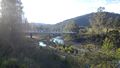
New Buildings Bridge.
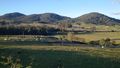
Rocky Hall Cemetery viewed from above.
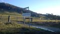
Rocky Hall.
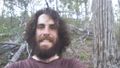
Me.
GPS.


Achievements
Lachie earned the OpenStreetMap achievement
|
Lachie earned the Bicycle geohash achievement
|