Difference between revisions of "2014-07-08 50 8"
From Geohashing
imported>Rincewind (About 90 m to the geohash point) |
imported>FippeBot m (Location) |
||
| (9 intermediate revisions by 2 users not shown) | |||
| Line 1: | Line 1: | ||
| − | |||
| − | |||
| − | |||
| − | |||
| − | |||
| − | |||
| − | |||
| − | |||
| − | |||
{{meetup graticule | {{meetup graticule | ||
| − | | lat=50 | + | | lat=50 |
| − | | lon=8 | + | | lon=8 |
| − | | date=2014-07-08 | + | | date=2014-07-08 |
}} | }} | ||
| − | |||
| − | |||
== Location == | == Location == | ||
| − | + | ||
| + | On a cornfield near Gruenberg, Hessen. | ||
== Participants == | == Participants == | ||
| − | + | *[[User:Yakamoz|Yakamoz]] | |
| − | + | *[[User:Rincewind| Rincewind]] | |
| + | |||
== Plans == | == Plans == | ||
| − | + | To use a short break in continuous rain and get a Birthday Geohash Achievement. | |
== Expedition == | == Expedition == | ||
| − | + | Since the hash point was just 20km out and fairly easy to reach, we could not NOT go. When the weather cleared up, we drove out and parked some 400m or so off the hash coordinates, when a sign prohibited us from driving on. We found the hash to be located just on the boarder of two fields. These were planted with just enough space to walk in wihtout causing damage to the crop, fortunately. One row into the corn field, we reached the hash coordinates without even doing the GPS dance. A fairly easy expedition, and there was cake. :) | |
| − | |||
| − | |||
| − | |||
== Photos == | == Photos == | ||
| Line 39: | Line 27: | ||
<gallery perrow="5"> | <gallery perrow="5"> | ||
| − | Image:2014-07- | + | Image:20140708_155248.jpg | Coordinates reached |
| + | |||
| + | |||
| + | Image:20140708_155525.jpg | Dirty shoes again | ||
| + | Image: 20140708_155652(0).jpg | Birthday cake | ||
| + | Image: 2014-07-08 50 8 hashproof.jpg|Hashproof | ||
| + | |||
</gallery> | </gallery> | ||
== Achievements == | == Achievements == | ||
{{#vardefine:ribbonwidth|800px}} | {{#vardefine:ribbonwidth|800px}} | ||
| − | |||
| + | {{land geohash | ||
| + | | latitude = 50 | ||
| + | | longitude = 8 | ||
| + | | date = 2014-07-08 | ||
| + | | name = Yakamoz and Rincewind | ||
| + | }} | ||
| + | {{Birthday geohash | ||
| − | + | | latitude = 50 | |
| − | + | | longitude = 8 | |
| − | + | | date = 2014-07-08 | |
| + | | pronoun = her | ||
| + | | name = Yakamoz | ||
| − | + | }} | |
| − | |||
| − | |||
| − | |||
| − | |||
| − | |||
| − | |||
[[Category:Expeditions]] | [[Category:Expeditions]] | ||
| − | |||
[[Category:Expeditions with photos]] | [[Category:Expeditions with photos]] | ||
| − | |||
| − | |||
| − | |||
| − | |||
| − | |||
[[Category:Coordinates reached]] | [[Category:Coordinates reached]] | ||
| − | + | {{location|DE|HE|GI}} | |
| − | |||
| − | |||
| − | |||
| − | |||
| − | |||
| − | |||
| − | |||
| − | |||
| − | |||
| − | |||
| − | |||
| − | |||
| − | |||
| − | |||
| − | |||
| − | |||
| − | |||
Latest revision as of 00:39, 15 August 2019
| Tue 8 Jul 2014 in 50,8: 50.5474889, 8.9434451 geohashing.info google osm bing/os kml crox |
Location
On a cornfield near Gruenberg, Hessen.
Participants
Plans
To use a short break in continuous rain and get a Birthday Geohash Achievement.
Expedition
Since the hash point was just 20km out and fairly easy to reach, we could not NOT go. When the weather cleared up, we drove out and parked some 400m or so off the hash coordinates, when a sign prohibited us from driving on. We found the hash to be located just on the boarder of two fields. These were planted with just enough space to walk in wihtout causing damage to the crop, fortunately. One row into the corn field, we reached the hash coordinates without even doing the GPS dance. A fairly easy expedition, and there was cake. :)
Photos
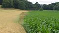
Coordinates reached
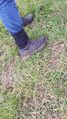
Dirty shoes again

Birthday cake
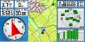
Hashproof


.jpg)

Achievements
Yakamoz and Rincewind earned the Land geohash achievement
|
Yakamoz earned the Birthday Geohash Achievement
|