Difference between revisions of "2014-07-25 35 -102"
imported>Michael5000 m (→Participants) |
imported>FippeBot m (Location) |
||
| (One intermediate revision by one other user not shown) | |||
| Line 23: | Line 23: | ||
== Participants == | == Participants == | ||
| − | * [[User:Michael5000|Michael5000]] | + | * [[User:Michael5000|Michael5000]] |
| − | |||
| − | |||
| − | |||
== Expedition == | == Expedition == | ||
| − | |||
| − | + | After the [[2014-07-25 34 -101]] Expedition, I rested up in Amarillo, then headed west on I-40. At Vega I turned south on U.S. 385, crossed into Deaf Smith County -- I've always loved that name! -- and headed west on Farm Road 2587. That landed me very near the hashpoint, which was right on the shoulder of Road #24. I drove over it, and then went back for the traditional barrage of photos. | |
| − | |||
== Photos == | == Photos == | ||
| − | + | ||
| − | |||
| − | |||
<gallery perrow="5"> | <gallery perrow="5"> | ||
| + | File:2014-07-25 35 -102 (9).JPG|Deaf Smith County! | ||
| + | File:2014-07-25 35 -102 (1).JPG|Heading west on Farm Road 2587 with an excited hashscot. In Texas, the speed limit for this kind of road is 75 MPH. | ||
| + | File:2014-07-25 35 -102 (2).JPG|The hashpoint shot. | ||
| + | File:2014-07-25 35 -102 (3).JPG|The goofy grin, both goofier and grinnier than usual. | ||
| + | File:2014-07-25 35 -102 (4).JPG|Looking south from the hashpoint. | ||
| + | File:2014-07-25 35 -102 (5).JPG|Looking west from the hashpoint. | ||
| + | File:2014-07-25 35 -102 (6).JPG|Looking north from the hashpoint. | ||
| + | File:2014-07-25 35 -102 (7).JPG|Looking east from the hashpoint. | ||
| + | File:2014-07-25 35 -102 (8).JPG|Looking ferocious at the hashpoint. | ||
</gallery> | </gallery> | ||
| Line 46: | Line 48: | ||
| − | |||
| − | |||
| − | |||
| − | |||
| − | |||
| − | |||
| − | |||
| − | |||
| − | |||
| − | |||
| − | |||
| − | |||
[[Category:Expeditions]] | [[Category:Expeditions]] | ||
| − | |||
[[Category:Expeditions with photos]] | [[Category:Expeditions with photos]] | ||
| − | |||
| − | |||
| − | |||
| − | |||
| − | |||
[[Category:Coordinates reached]] | [[Category:Coordinates reached]] | ||
| − | + | *I am the third person ever to geohash the Vega graticule! | |
| − | + | {{location|US|TX|DI}} | |
| − | |||
| − | |||
| − | |||
| − | |||
| − | |||
| − | |||
| − | |||
| − | |||
| − | |||
| − | |||
| − | |||
| − | |||
| − | |||
| − | |||
| − | |||
Latest revision as of 00:26, 7 August 2019
| Fri 25 Jul 2014 in 35,-102: 35.1078151, -102.6790129 geohashing.info google osm bing/os kml crox |
Location
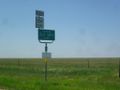
On Deaf Smith County Road #24, off of Texas Highway 214.
Participants
Expedition
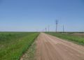
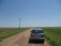
After the 2014-07-25 34 -101 Expedition, I rested up in Amarillo, then headed west on I-40. At Vega I turned south on U.S. 385, crossed into Deaf Smith County -- I've always loved that name! -- and headed west on Farm Road 2587. That landed me very near the hashpoint, which was right on the shoulder of Road #24. I drove over it, and then went back for the traditional barrage of photos.
Photos
Deaf Smith County!
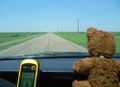
Heading west on Farm Road 2587 with an excited hashscot. In Texas, the speed limit for this kind of road is 75 MPH.
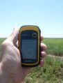
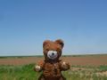
The hashpoint shot.
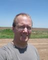
The goofy grin, both goofier and grinnier than usual.
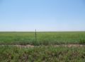
Looking south from the hashpoint.
Looking west from the hashpoint.
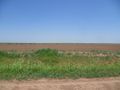
Looking north from the hashpoint.
Looking east from the hashpoint.
Looking ferocious at the hashpoint.
.JPG)
.JPG)
.JPG)
.JPG)
.JPG)
.JPG)
.JPG)
.JPG)
.JPG)
Achievements
- I am the third person ever to geohash the Vega graticule!