Difference between revisions of "2014-08-02 59 21"
From Geohashing
imported>Tilley |
m (per Renaming Proposal) |
||
| (4 intermediate revisions by 4 users not shown) | |||
| Line 37: | Line 37: | ||
== Tracklog == | == Tracklog == | ||
<!-- if your GPS device keeps a log, you may post a link here --> | <!-- if your GPS device keeps a log, you may post a link here --> | ||
| + | Look from [[2014-08-02_59_24 | the first hash of the trip...]] | ||
| + | {{tracklog|2014-08-02 Bysmyyr Tracklog.gpx}} | ||
== Photos == | == Photos == | ||
| Line 51: | Line 53: | ||
<!-- Add any achievement ribbons you earned below, or remove this section --> | <!-- Add any achievement ribbons you earned below, or remove this section --> | ||
| − | {{ | + | {{Graticule unlocked |
| latitude = 59 | | latitude = 59 | ||
| longitude = 21 | | longitude = 21 | ||
| Line 63: | Line 65: | ||
<!-- =============== USEFUL CATEGORIES FOLLOW ================ | <!-- =============== USEFUL CATEGORIES FOLLOW ================ | ||
Delete the next line ONLY if you have chosen the appropriate categories below. If you are unsure, don't worry. People will read your report and help you with the classification.--> | Delete the next line ONLY if you have chosen the appropriate categories below. If you are unsure, don't worry. People will read your report and help you with the classification.--> | ||
| − | + | ||
<!-- ==REQUEST FOR TWITTER BOT== Please leave either the New report or the Expedition planning category in as long as you work on it. This helps the twitter bot a lot with announcing the right outcome at the right moment. --> | <!-- ==REQUEST FOR TWITTER BOT== Please leave either the New report or the Expedition planning category in as long as you work on it. This helps the twitter bot a lot with announcing the right outcome at the right moment. --> | ||
| Line 72: | Line 74: | ||
--> | --> | ||
| − | |||
[[Category:Expeditions]] | [[Category:Expeditions]] | ||
| − | + | ||
[[Category:Expeditions with photos]] | [[Category:Expeditions with photos]] | ||
| − | + | ||
| − | |||
| − | |||
| − | |||
| − | |||
[[Category:Coordinates reached]] | [[Category:Coordinates reached]] | ||
| − | + | {{location|FI|19}} | |
| − | |||
| − | |||
| − | |||
| − | |||
| − | |||
| − | |||
| − | |||
| − | |||
| − | |||
| − | |||
| − | |||
| − | |||
| − | |||
| − | |||
| − | |||
| − | |||
| − | |||
Latest revision as of 05:10, 20 March 2024
| Sat 2 Aug 2014 in 59,21: 59.9228439, 21.4103215 geohashing.info google osm bing/os kml crox |
Location
At the sea in a national park
Participants
My girlfriend
Plans
Nothing unusual, we thought that this was maybe the most beautiful hash. We just flew from the previous hash: 2014-08-02_59_22. This one is hash 4/10, starting from: 2014-08-02_59_24
Expedition
Place was beautiful, sad because our camera was poor. You should go to there if you can! After this we had to go directly to 2014-08-02_60_22 because program was starting in MAF fly-in near that hash. We had to take 2014-08-02_60_21 later.
Tracklog
Look from the first hash of the trip...
Photos
Proof
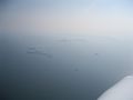
The hash


Achievements
Bysmyyr earned the Graticule Unlocked Achievement
|
Bysmyyr earned the Air geohash achievement
|