Difference between revisions of "2014-08-21 46 11"
imported>Werther |
m (Location correction) |
||
| (5 intermediate revisions by 2 users not shown) | |||
| Line 21: | Line 21: | ||
== Participants == | == Participants == | ||
| − | [User:Werther|Werther] | + | [[User:Werther|Werther]] |
== Plans == | == Plans == | ||
| Line 29: | Line 29: | ||
== Expedition == | == Expedition == | ||
| − | + | Got off to a good start- I missed the bus to the city. Well, I actually was on time at the bus stop, but being early afternoon of a late August day, the bus was a couple minutes early on schedule. So I had to walk to an intercity bus stop, as if my plans for the day didn't include enough walking... I decided to stop to a closer bus stop rather than walk all the way to the station, to avoid missing another bus. A lady, who was waiting there as well, informed me that I was supposed to take a Borgo Valsugana-bound and then switch to another bus to Bosco along the SS47 highway. You couldn't really figure this out from the timetables (I thought there would only be one bus)- so she really saved the day. The bus to Borgo came on time- it was an articulated bus, and it was quite crowded. | |
| − | + | When I switched to the smaller coach to Bosco, only a few people followed me on board. I passed by Civezzano and a [[2013-04-08 46 11|geohash]] I had reached in an earlier expedition. I tried to take a photo of the hash from the bus, but had limited success. I then realized I couldn't really claim a Tron achievement on this, as the coach was serving a range of tiny mountain hamlets which included several cul-de-sacs and repeating the same road several times. No one came on board along the way and we arrived in Bosco 5 minutes earlier than predicted. | |
| − | + | ||
| + | From Bosco, I had to follow a paved road uphill until a small group of houses... at least according to OpenStreetMap. However, I couldn't quite find my way once I reached the spot. The GPS reception was very poor and there was no internet connection for my phone either. At some point, I ignored a roadsign which was pointing to my destination because it clashed with my notes, but I later realized that I was wrong... and that I'd better follow the road signs rather than trust my indications blindly. | ||
| + | |||
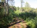
| + | The paved road eventually ended and I entered the Grave biotope- a swampy protected area home to several trees and small animals. As I was going deep into the woods, I recognized several locations I had seen on OpenStreetMap and felt more at ease. I found a couple tricky intersections, but I was able to make the right choices in the end. Trouble came again once I reached trail no. 421, a bigger dirt road which links Montevaccino with the S.Colomba lake. I knew that, once I reached the trail, I had to turn left and then turn right almost suddenly. But I wasn't able to find the right turn. I walked quite a bit until I found a road which looked like mine, but it shortly ended in front of a small house with a garden. That wasn't what I was looking for, so I came back to the intersection only to realize that there was a 4th road at the fork- and that what I thought was the right branch of trail no. 421 was the road I was supposed to take! | ||
| + | |||
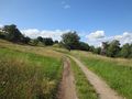
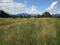
| + | It was a bit of a mess, but I was able to reach the fields where my hash was supposedly located. And it was definitely worth it: the scenery was amazing. The GPS receiver was still having some trouble, but my phone started working so I reached my first hash by using the Android app- it was in tall grass, so I did everything in a bit of a rush... I had shorts on and I wanted to avoid ticks, or worse, vipers. | ||
| + | |||
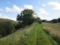
| + | The expedition wasn't over yet though: rather than going back to Bosco, where there were only a few buses every day, I made a loop to another village, Montevaccino (literally Cow Mountain). I followed a narrow and muddy trail with no kind of signs, and at some point I genuinely started to wonder whether I was going somewhere or just getting lost in the woods. Luckily, I found the aforementioned trail no. 421 after a good 10 minutes, and followed it until my destination, passing through the awesomely-named Mont de la Galina (Chicken mountain). My right shoe was starting to hurt my feet, and I can say I didn't really enjoy the last part of the expedition because of that. I arrived in Montevaccino some 5 minutes before a bus left towards Martignano, so I took advantage of that perfect timing and rode the bus to my village's main square, from where I walked the remaining 10 minutes towards home. | ||
== Photos == | == Photos == | ||
| Line 39: | Line 46: | ||
--> | --> | ||
<gallery perrow="5"> | <gallery perrow="5"> | ||
| + | Image:20140821 Calisio 001.JPG|This is how the [[2013-04-08 46 11|2013-04-08]] hash looks from a moving bus! | ||
| + | Image:20140821 Calisio 002.JPG|The bus stop in the lovely hamlet of Bosco | ||
| + | Image:20140821 Calisio 003.JPG|There goes the asphalt. Dirt roads begin! | ||
| + | Image:20140821 Calisio 004.JPG|Entering the Le Grave biotope | ||
| + | Image:20140821 Calisio 005.JPG|Did I say dirt? Whoops, I meant watery mud! | ||
| + | Image:20140821 Calisio 006.JPG|This is why I love going to random spots around the globe | ||
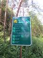
| + | Image:20140821 Calisio 007.JPG|This, also. | ||
| + | Image:20140821 Calisio 008.JPG|The patch of field the hash was in. | ||
| + | Image:20140821 Calisio 012.png|Coordinates reached! | ||
| + | Image:20140821 Calisio 009.JPG|The narrow trail back to Montevaccino | ||
| + | Image:20140821 Calisio 010.JPG|On my way, I forgot I realized my stupid grin. So here you go! | ||
| + | Image:20140821 Calisio 011.JPG|The church in Montevaccino, with my bus waiting at the stop. | ||
</gallery> | </gallery> | ||
| − | |||
| − | |||
| − | |||
| − | |||
| − | |||
| − | |||
| − | |||
| − | |||
| − | |||
| − | |||
| − | + | [[Category:Expeditions]] | |
| − | + | [[Category:Coordinates reached]] | |
| − | [[Category: | + | {{location|IT|TT}} |
| − | |||
Latest revision as of 15:11, 28 July 2021
| Thu 21 Aug 2014 in 46,11: 46.1275392, 11.1651009 geohashing.info google osm bing/os kml crox |
Location
In the woods west of St. Colomba lake, north of Civezzano. A meadowy area.
Participants
Plans
So yeah- I haven't been on an expedition for more than six months, and only once in the past year! Time to fix this. I had considered yesterday's location in 45-11 but the weather was too bad so I abandoned my plans. Today I get a hash which is close to home, in an area I know fairly well, and the sun is shining too. I have no excuse!
I'm going for a Tron achievement or honorable mention at least. On my way to the hash I will take an intercity bus to Bosco di Civezzano and get to the hash from there- I don't really know the area so I thought of this detour to enjoy a bit of exploration. Instead, on my way back, I will take the main trail to Montevaccino and get back home with the city bus from there. Since buses only run every 40 minutes, if I won't get there in time I will just walk all the way to Martignano.
Expedition
Got off to a good start- I missed the bus to the city. Well, I actually was on time at the bus stop, but being early afternoon of a late August day, the bus was a couple minutes early on schedule. So I had to walk to an intercity bus stop, as if my plans for the day didn't include enough walking... I decided to stop to a closer bus stop rather than walk all the way to the station, to avoid missing another bus. A lady, who was waiting there as well, informed me that I was supposed to take a Borgo Valsugana-bound and then switch to another bus to Bosco along the SS47 highway. You couldn't really figure this out from the timetables (I thought there would only be one bus)- so she really saved the day. The bus to Borgo came on time- it was an articulated bus, and it was quite crowded.
When I switched to the smaller coach to Bosco, only a few people followed me on board. I passed by Civezzano and a geohash I had reached in an earlier expedition. I tried to take a photo of the hash from the bus, but had limited success. I then realized I couldn't really claim a Tron achievement on this, as the coach was serving a range of tiny mountain hamlets which included several cul-de-sacs and repeating the same road several times. No one came on board along the way and we arrived in Bosco 5 minutes earlier than predicted.
From Bosco, I had to follow a paved road uphill until a small group of houses... at least according to OpenStreetMap. However, I couldn't quite find my way once I reached the spot. The GPS reception was very poor and there was no internet connection for my phone either. At some point, I ignored a roadsign which was pointing to my destination because it clashed with my notes, but I later realized that I was wrong... and that I'd better follow the road signs rather than trust my indications blindly.
The paved road eventually ended and I entered the Grave biotope- a swampy protected area home to several trees and small animals. As I was going deep into the woods, I recognized several locations I had seen on OpenStreetMap and felt more at ease. I found a couple tricky intersections, but I was able to make the right choices in the end. Trouble came again once I reached trail no. 421, a bigger dirt road which links Montevaccino with the S.Colomba lake. I knew that, once I reached the trail, I had to turn left and then turn right almost suddenly. But I wasn't able to find the right turn. I walked quite a bit until I found a road which looked like mine, but it shortly ended in front of a small house with a garden. That wasn't what I was looking for, so I came back to the intersection only to realize that there was a 4th road at the fork- and that what I thought was the right branch of trail no. 421 was the road I was supposed to take!
It was a bit of a mess, but I was able to reach the fields where my hash was supposedly located. And it was definitely worth it: the scenery was amazing. The GPS receiver was still having some trouble, but my phone started working so I reached my first hash by using the Android app- it was in tall grass, so I did everything in a bit of a rush... I had shorts on and I wanted to avoid ticks, or worse, vipers.
The expedition wasn't over yet though: rather than going back to Bosco, where there were only a few buses every day, I made a loop to another village, Montevaccino (literally Cow Mountain). I followed a narrow and muddy trail with no kind of signs, and at some point I genuinely started to wonder whether I was going somewhere or just getting lost in the woods. Luckily, I found the aforementioned trail no. 421 after a good 10 minutes, and followed it until my destination, passing through the awesomely-named Mont de la Galina (Chicken mountain). My right shoe was starting to hurt my feet, and I can say I didn't really enjoy the last part of the expedition because of that. I arrived in Montevaccino some 5 minutes before a bus left towards Martignano, so I took advantage of that perfect timing and rode the bus to my village's main square, from where I walked the remaining 10 minutes towards home.
Photos
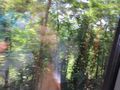
This is how the 2013-04-08 hash looks from a moving bus!
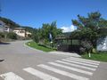
The bus stop in the lovely hamlet of Bosco
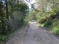
There goes the asphalt. Dirt roads begin!
Entering the Le Grave biotope
Did I say dirt? Whoops, I meant watery mud!
This is why I love going to random spots around the globe
This, also.
The patch of field the hash was in.
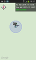
Coordinates reached!
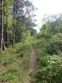
The narrow trail back to Montevaccino
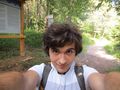
On my way, I forgot I realized my stupid grin. So here you go!
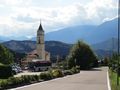
The church in Montevaccino, with my bus waiting at the stop.


