Difference between revisions of "2014-08-31 39 -76"
From Geohashing
imported>OfficeLinebacker ([live picture] Silly grin [http://www.openstreetmap.org/?lat=39.36600000&lon=-76.58820000&zoom=16&layers=B000FTF @39.3660,-76.5882]) |
imported>FippeBot m (Location) |
||
| (8 intermediate revisions by 2 users not shown) | |||
| Line 19: | Line 19: | ||
== Location == | == Location == | ||
<!-- where you've surveyed the hash to be --> | <!-- where you've surveyed the hash to be --> | ||
| + | On a road near Morgan State University in Baltimore, Maryland. | ||
== Participants == | == Participants == | ||
<!-- who attended: If you link to your wiki user name in this section, your expedition will be picked up by the various statistics generated for geohashing. You may use three tildes ~ as a shortcut to automatically insert the user signature of the account you are editing with. | <!-- who attended: If you link to your wiki user name in this section, your expedition will be picked up by the various statistics generated for geohashing. You may use three tildes ~ as a shortcut to automatically insert the user signature of the account you are editing with. | ||
--> | --> | ||
| + | [[User:OfficeLinebacker|OfficeLinebacker]] ([[User talk:OfficeLinebacker|talk]])OfficeLinebacker | ||
== Plans == | == Plans == | ||
<!-- what were the original plans --> | <!-- what were the original plans --> | ||
| + | To drive to Baltimore, meet up with some friends at Loyola College, and then proceed to the geohash point and attempt a Speed Racer. | ||
== Expedition == | == Expedition == | ||
<!-- how it all turned out. your narrative goes here. --> | <!-- how it all turned out. your narrative goes here. --> | ||
| + | Everything turned out as expected! Loyola is a beautiful campus in Baltimore and this area was about a mile and a half away, a little less nice area but still fine. Did the Speed Racer, then made some turns and went back, pulled over, and took some pics. | ||
== Tracklog == | == Tracklog == | ||
| Line 40: | Line 44: | ||
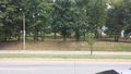
Image:2014-08-31_39_-76_12-22-47-190.jpg | Silly grin [http://www.openstreetmap.org/?lat=39.36600000&lon=-76.58820000&zoom=16&layers=B000FTF @39.3660,-76.5882] | Image:2014-08-31_39_-76_12-22-47-190.jpg | Silly grin [http://www.openstreetmap.org/?lat=39.36600000&lon=-76.58820000&zoom=16&layers=B000FTF @39.3660,-76.5882] | ||
| + | |||
| + | Image:2014-08-31_39_-76_12-23-13-713.jpg | Across the street [http://www.openstreetmap.org/?lat=39.36580000&lon=-76.58830000&zoom=16&layers=B000FTF @39.3658,-76.5883] | ||
| + | |||
| + | Image:2014-08-31_39_-76_12-23-37-621.jpg | The house in front [http://www.openstreetmap.org/?lat=39.36580000&lon=-76.58830000&zoom=16&layers=B000FTF @39.3658,-76.5883] | ||
</gallery> | </gallery> | ||
| Line 45: | Line 53: | ||
{{#vardefine:ribbonwidth|800px}} | {{#vardefine:ribbonwidth|800px}} | ||
<!-- Add any achievement ribbons you earned below, or remove this section --> | <!-- Add any achievement ribbons you earned below, or remove this section --> | ||
| + | {{Speed racer | ||
| + | | latitude = 39 | ||
| + | | longitude = -76 | ||
| + | | date = 2014-08-31 | ||
| + | | name = OfficeLinebacker | ||
| + | | speed = 30 MPH | ||
| + | }} | ||
| − | |||
| − | |||
| − | |||
| − | |||
| − | |||
| − | |||
| − | |||
| − | |||
| − | |||
| − | |||
| − | |||
| − | |||
[[Category:Expeditions]] | [[Category:Expeditions]] | ||
| − | |||
[[Category:Expeditions with photos]] | [[Category:Expeditions with photos]] | ||
| − | |||
| − | |||
| − | |||
| − | |||
| − | |||
[[Category:Coordinates reached]] | [[Category:Coordinates reached]] | ||
| − | + | {{location|US|MD|BA}} | |
| − | |||
| − | |||
| − | |||
| − | |||
| − | |||
| − | |||
| − | |||
| − | |||
| − | |||
| − | |||
| − | |||
| − | |||
| − | |||
| − | |||
| − | |||
| − | |||
| − | |||
Latest revision as of 00:33, 7 August 2019
| Sun 31 Aug 2014 in 39,-76: 39.3660226, -76.5881789 geohashing.info google osm bing/os kml crox |
Location
On a road near Morgan State University in Baltimore, Maryland.
Participants
OfficeLinebacker (talk)OfficeLinebacker
Plans
To drive to Baltimore, meet up with some friends at Loyola College, and then proceed to the geohash point and attempt a Speed Racer.
Expedition
Everything turned out as expected! Loyola is a beautiful campus in Baltimore and this area was about a mile and a half away, a little less nice area but still fine. Did the Speed Racer, then made some turns and went back, pulled over, and took some pics.
Tracklog
Photos

Silly grin @39.3660,-76.5882
Across the street @39.3658,-76.5883
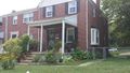
The house in front @39.3658,-76.5883


Achievements

OfficeLinebacker earned the Speed racer achievement
by passing through the (39, -76) geohash on 2014-08-31 at 30 MPH.