Difference between revisions of "2014-09-08 49 7"
imported>Q-Owl (Created page with "<!-- If you did not specify these parameters in the template, please substitute appropriate values for IMAGE, LAT, LON, and DATE (YYYY-MM-DD format) Image:{{{image|IMAGE}}...") |
m (Location correction) |
||
| (13 intermediate revisions by 2 users not shown) | |||
| Line 1: | Line 1: | ||
<!-- If you did not specify these parameters in the template, please substitute appropriate values for IMAGE, LAT, LON, and DATE (YYYY-MM-DD format) | <!-- If you did not specify these parameters in the template, please substitute appropriate values for IMAGE, LAT, LON, and DATE (YYYY-MM-DD format) | ||
| − | [[Image: | + | [[Image:2014-09-08 49 7 west.jpg|thumb|left]] |
Remove this section if you don't want an image at the top (left) of your report. | Remove this section if you don't want an image at the top (left) of your report. | ||
You should remove the "Image:" or "File:" tag from your image file name, | You should remove the "Image:" or "File:" tag from your image file name, | ||
| Line 8: | Line 8: | ||
And DON'T FORGET to add your expedition and the best photo you took to the gallery on the Main Page! We'd love to read your report, but that means we first have to discover it! :) | And DON'T FORGET to add your expedition and the best photo you took to the gallery on the Main Page! We'd love to read your report, but that means we first have to discover it! :) | ||
--> | --> | ||
| − | + | [[Image:2014-09-08 49 7 Luitpoldsturm.jpg|thumb|left|Luitpold Tower]] | |
{{meetup graticule | {{meetup graticule | ||
| lat=49 | | lat=49 | ||
| lon=7 | | lon=7 | ||
| date=2014-09-08 | | date=2014-09-08 | ||
| − | }} | + | }}__NOTOC__ |
| − | __NOTOC__ | ||
== Location == | == Location == | ||
| − | In the [[wikipedia:Palatinate_Forest|Palatinate Forest]] | + | In the [[wikipedia:Palatinate_Forest|Palatinate Forest]] about 180 m SE from the [[wikipedia:Luitpold_Tower|Luitpold Tower]] on the Weissenberg (about 10 km south of [[wikipedia:Johanniskreuz|Johanniskreuz]]). |
== Participants == | == Participants == | ||
| − | * [[User:Q-Owl|Q-Owl]] | + | *[[User:Q-Owl|Q-Owl]] |
| + | *[[User:Q-Owla|Q-Owla]] | ||
== Plan == | == Plan == | ||
| Line 29: | Line 29: | ||
== Expedition == | == Expedition == | ||
| − | + | For the last night of our motorhome holiday we had found a nice place to stay, about 4 km E from Johanniskreuz. | |
| − | |||
| − | |||
| − | |||
| − | + | During breakfast I recognized, that todays hashpoint was very near. My wife, Q-Owla, liked the idea to visit it very much. So we drove to a parking place near the Luitpold Tower, vistited the tower and one of the geocaches there. The banner at the tower is a protest against wind generators. | |
| − | + | Later we went back to the car, drove a few meters and stopped near the hashpoint, which was 20 m west to the road. | |
| − | + | The coordinates were not easy to find under the trees, but after some walking around I was sucessfull. A nice surprise, event and experience at the very last day of our trip. On our way back we found some tasty [[wikipedia:Lactarius_deliciosus|Red pine mushrooms]] (Edelreizker). | |
| − | + | ||
| + | It was so nice here, that we came back to this area 25 days later. | ||
== Photos == | == Photos == | ||
| Line 44: | Line 42: | ||
Image:2014-##-## ## ## Alpha.jpg | Witty Comment | Image:2014-##-## ## ## Alpha.jpg | Witty Comment | ||
--> | --> | ||
| − | + | ||
| − | |||
<gallery perrow="5" > | <gallery perrow="5" > | ||
| − | Image:2014-09-08 49 7 proof.png | Proof | + | Image:2014-09-08 49 7 Luitpoldsturm.jpg | Luitpoldsturm |
| + | Image:2014-09-08 49 7 view.jpg | View from the tower to the hp area, 180 m SE from here | ||
| + | Image:20140908 104005-kl.jpg | 15 m this direction! | ||
| + | Image:2014-09-08 49 7 stone.jpg | Borderstone near the cache | ||
| + | Image:2014-09-08 49 7 proof.png | Proof | ||
Image:2014-09-08 49 7 east.jpg | East | Image:2014-09-08 49 7 east.jpg | East | ||
| − | Image:2014-09-08 49 7 west.jpg | West | + | Image:2014-09-08 49 7 west.jpg | West(?) |
| − | + | Image:20140908_105551-kl.jpg | Happy grin | |
| − | Image:2014-09-08 49 7 | + | Image:2014-09-08 49 7 mu.jpg | Red pine mushrooms |
</gallery> | </gallery> | ||
| − | |||
<!-- | <!-- | ||
List of uploaded Files: | List of uploaded Files: | ||
http://wiki.xkcd.com/wgh/index.php?title=Special%3AListFiles&limit=50&ilsearch=&user=Q-Owl | http://wiki.xkcd.com/wgh/index.php?title=Special%3AListFiles&limit=50&ilsearch=&user=Q-Owl | ||
| − | + | ||
| + | More information: http://wiki.xkcd.com/geohashing/User:Q-Owl#HowTo_in_this_Wiki | ||
--> | --> | ||
== Achievements / Honorable Mention == | == Achievements / Honorable Mention == | ||
| − | {{#vardefine:ribbonwidth| | + | {{#vardefine:ribbonwidth|700px}} |
{{land geohash | {{land geohash | ||
| latitude = 49 | | latitude = 49 | ||
| Line 69: | Line 70: | ||
| name = Q-Owl | | name = Q-Owl | ||
}} | }} | ||
| − | + | {{Hash collision | |
| − | |||
| − | {{ | ||
| latitude = 49 | | latitude = 49 | ||
| − | | longitude = | + | | longitude = 7 |
| date = 2014-09-08 | | date = 2014-09-08 | ||
| − | |||
| name = Q-Owl | | name = Q-Owl | ||
| + | | id = GCA86 | ||
| + | | link = http://coord.info/GCA86 | ||
| + | | distance = 180 m | ||
| + | | honor = jes | ||
| + | }} 180 m from the hashpoint, but not in direct sight. One of the oldest GCs in Germany! | ||
| + | |||
| + | |||
| + | For the first time: | ||
| + | {{drag-along | ||
| + | | latitude = 49 | ||
| + | | longitude = 7 | ||
| + | | date = 2014-09-08 | ||
| + | | partner = Q-Owla | ||
| + | | name = Q-Owl | ||
| + | <!-- | ||
| + | | image = image name (optional) | ||
| + | --> | ||
}} | }} | ||
| − | {{ | + | {{Minesweeper geohash |
| − | + | | graticule = Mannheim, Germany | |
| − | + | | ranknumber = 1 | |
| − | + | | w = true | |
| − | + | | name = Q-Owl | |
| − | |||
| − | |||
| − | |||
}} | }} | ||
| − | |||
| − | |||
| − | |||
| − | |||
| − | |||
| − | |||
<!-- =============== USEFUL CATEGORIES FOLLOW ================ --> | <!-- =============== USEFUL CATEGORIES FOLLOW ================ --> | ||
| Line 111: | Line 117: | ||
[[Category: Meetup on 2014-06-27]] | [[Category: Meetup on 2014-06-27]] | ||
[[Category: Meetup in 49 8]]--> | [[Category: Meetup in 49 8]]--> | ||
| + | {{location|DE|RP|SÜW}} | ||
Latest revision as of 20:25, 16 May 2020

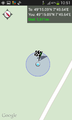
| Mon 8 Sep 2014 in 49,7: 49.2515374, 7.8272553 geohashing.info google osm bing/os kml crox |
Location
In the Palatinate Forest about 180 m SE from the Luitpold Tower on the Weissenberg (about 10 km south of Johanniskreuz).
Participants
Plan
Drive by Motorhome to the hash area.
Expedition
For the last night of our motorhome holiday we had found a nice place to stay, about 4 km E from Johanniskreuz.
During breakfast I recognized, that todays hashpoint was very near. My wife, Q-Owla, liked the idea to visit it very much. So we drove to a parking place near the Luitpold Tower, vistited the tower and one of the geocaches there. The banner at the tower is a protest against wind generators.
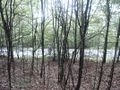
Later we went back to the car, drove a few meters and stopped near the hashpoint, which was 20 m west to the road. The coordinates were not easy to find under the trees, but after some walking around I was sucessfull. A nice surprise, event and experience at the very last day of our trip. On our way back we found some tasty Red pine mushrooms (Edelreizker).
It was so nice here, that we came back to this area 25 days later.
Photos
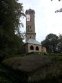
Luitpoldsturm
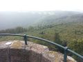
View from the tower to the hp area, 180 m SE from here
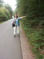
15 m this direction!
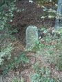
Borderstone near the cache
Proof
East
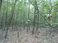
West(?)

Happy grin
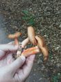
Red pine mushrooms


Achievements / Honorable Mention
Q-Owl earned the Land geohash achievement
|
Q-Owl earned the Hash collision honorable mention
|
180 m from the hashpoint, but not in direct sight. One of the oldest GCs in Germany!
For the first time:
Q-Owl earned the Drag-along achievement
|
Q-Owl achieved level 1 of the Minesweeper Geohash achievement
|