Difference between revisions of "2014-09-10 33 -97"
From Geohashing
imported>WalkerBR (Created page with "{{subst:Expedition |lat = 33 |lon = -97 |date = 2014-09-10 }}") |
imported>FippeBot m (Location) |
||
| (9 intermediate revisions by 2 users not shown) | |||
| Line 13: | Line 13: | ||
| lon=-97 | | lon=-97 | ||
| date=2014-09-10 | | date=2014-09-10 | ||
| + | | graticule_name=Denton | ||
| + | | graticule_link=Denton, Texas | ||
}} | }} | ||
| Line 18: | Line 20: | ||
__NOTOC__ | __NOTOC__ | ||
== Location == | == Location == | ||
| − | + | In a private road on Corinth, TX. | |
== Participants == | == Participants == | ||
| − | + | [[User:WalkerBR|WalkerBR]] ([[User talk:WalkerBR|talk]]) | |
| − | |||
== Plans == | == Plans == | ||
| Line 28: | Line 29: | ||
== Expedition == | == Expedition == | ||
| − | + | Quick trip by car on I-35E, took exit 461 and got on to Shady Shores Rd. Then took left on Lakeside Dr, and went on until the spot. The location was on the actual centerline of the road, which was not a problem as no car passed by while I was there. | |
== Tracklog == | == Tracklog == | ||
| Line 38: | Line 39: | ||
--> | --> | ||
<gallery perrow="5"> | <gallery perrow="5"> | ||
| + | Image:2014_09_10_33_-97_road.jpg | The road, and my car parked. | ||
| + | Image:2014_09_10_33_-97_WalkerBR.jpg | The expeditioneer. | ||
| + | Image:2014_09_10_33_-97_Cell.png | The proof. | ||
</gallery> | </gallery> | ||
== Achievements == | == Achievements == | ||
{{#vardefine:ribbonwidth|800px}} | {{#vardefine:ribbonwidth|800px}} | ||
| − | + | {{Land geohash|latitude=33|longitude=-97|date=2014-09-10|name=WalkerBR|image=2014_09_10_33_-97_Cell.png}} | |
| + | {{Speed racer|latitude=33|longitude=-97|date=2014-09-10|name=WalkerBR|image=2014_09_10_33_-97_road.jpg}} | ||
| − | |||
| − | |||
| − | |||
| − | |||
| − | |||
| − | |||
| − | |||
| − | |||
| − | |||
| − | |||
| − | |||
[[Category:Expeditions]] | [[Category:Expeditions]] | ||
| − | |||
[[Category:Expeditions with photos]] | [[Category:Expeditions with photos]] | ||
| − | |||
| − | |||
| − | |||
| − | |||
| − | |||
[[Category:Coordinates reached]] | [[Category:Coordinates reached]] | ||
| − | + | {{location|US|TX|DN}} | |
| − | |||
| − | |||
| − | |||
| − | |||
| − | |||
| − | |||
| − | |||
| − | |||
| − | |||
| − | |||
| − | |||
| − | |||
| − | |||
| − | |||
| − | |||
| − | |||
| − | |||
Latest revision as of 01:21, 15 August 2019
| Wed 10 Sep 2014 in Denton: 33.1676624, -97.0555764 geohashing.info google osm bing/os kml crox |
Location
In a private road on Corinth, TX.
Participants
Plans
Expedition
Quick trip by car on I-35E, took exit 461 and got on to Shady Shores Rd. Then took left on Lakeside Dr, and went on until the spot. The location was on the actual centerline of the road, which was not a problem as no car passed by while I was there.
Tracklog
Photos
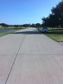
The road, and my car parked.
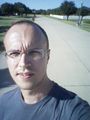
The expeditioneer.
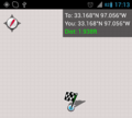
The proof.


Achievements
WalkerBR earned the Land geohash achievement
|

WalkerBR earned the Speed racer achievement
by passing through the (33, -97) geohash on 2014-09-10 at the maximum legal speed.
