Difference between revisions of "2014-09-14 45 -122"
From Geohashing
imported>Michael5000 m (→Photos) |
imported>FippeBot m (Location) |
||
| (5 intermediate revisions by 2 users not shown) | |||
| Line 23: | Line 23: | ||
== Participants == | == Participants == | ||
| + | ===Expedition5000=== | ||
* [[User:Michael5000|Michael5000]] | * [[User:Michael5000|Michael5000]] | ||
* [[User:Mrs.5000|Mrs.5000]] | * [[User:Mrs.5000|Mrs.5000]] | ||
| + | |||
| + | ===Expedition 2=== | ||
| + | * [[User:Frogman|Frogman]] | ||
| + | * [[User:Benture|Benture]] | ||
== Plans == | == Plans == | ||
| Line 31: | Line 36: | ||
== Expedition == | == Expedition == | ||
| + | ===Expedition5000=== | ||
At the end of an eight-day road trip on which we looked for hashpoints every single day, we finally found one... 10 miles from home. We visited the spot on our way back into town. | At the end of an eight-day road trip on which we looked for hashpoints every single day, we finally found one... 10 miles from home. We visited the spot on our way back into town. | ||
| − | == | + | ===Expedition 2=== |
| − | + | Even though Benture had just gotten back from Cycle Oregon, we decided to ride our bikes up to this hashpoint. It was a pleasant ride! | |
== Photos == | == Photos == | ||
| Line 42: | Line 48: | ||
File:2014-09-14 45 -122 me.JPG|Reasonable approximation of goofy grin. | File:2014-09-14 45 -122 me.JPG|Reasonable approximation of goofy grin. | ||
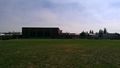
File:2014-09-14 45 -122 school.JPG|Entrance to the high school. The hashpoint was on a playing field in back. | File:2014-09-14 45 -122 school.JPG|Entrance to the high school. The hashpoint was on a playing field in back. | ||
| + | File:2014-09-14 45 -122 track.jpg|A nearby athletic track. | ||
| + | File:2014-09-14 45 -122 school2.jpg|A nearby highschool, as viewed from the hashpoint. | ||
| + | File:2014-09-14 45 -122 grins.jpg|Grins! | ||
| + | File:2014-09-14 45 -122 bikescot.jpg|My hashscot rode the whole way there; his legs were tired. | ||
</gallery> | </gallery> | ||
| Line 48: | Line 58: | ||
<!-- Add any achievement ribbons you earned below, or remove this section --> | <!-- Add any achievement ribbons you earned below, or remove this section --> | ||
| − | + | {{bicycle geohash | |
| − | + | | latitude = 45 | |
| − | [[ | + | | longitude = -122 |
| − | + | | date = 2014-09-14 | |
| + | | name = [[User:Frogman|Frogman]] and [[User:Benture|Benture]] | ||
| + | | distance = 33 miles | ||
| + | }} | ||
[[Category:Expeditions]] | [[Category:Expeditions]] | ||
| Line 59: | Line 72: | ||
[[Category:Coordinates reached]] | [[Category:Coordinates reached]] | ||
| + | {{location|US|WA|CR}} | ||
Latest revision as of 01:25, 15 August 2019
| Sun 14 Sep 2014 in 45,-122: 45.6255643, -122.4690962 geohashing.info google osm bing/os kml crox |
Location
On the grounds of Union High School, on the eastern fringe of Vancouver.
Participants
Expedition5000
Expedition 2
Plans
Expedition
Expedition5000
At the end of an eight-day road trip on which we looked for hashpoints every single day, we finally found one... 10 miles from home. We visited the spot on our way back into town.
Expedition 2
Even though Benture had just gotten back from Cycle Oregon, we decided to ride our bikes up to this hashpoint. It was a pleasant ride!
Photos
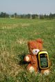
It said zero when he sat down.
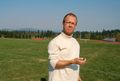
Reasonable approximation of goofy grin.
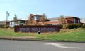
Entrance to the high school. The hashpoint was on a playing field in back.
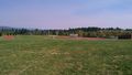
A nearby athletic track.
A nearby highschool, as viewed from the hashpoint.

Grins!
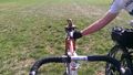
My hashscot rode the whole way there; his legs were tired.


Achievements
Frogman and Benture earned the Bicycle geohash achievement
|