Difference between revisions of "2014-09-28 46 11"
imported>GeorgDerReisende (Category ''Meetup pages without template'' added) |
m (Location correction) |
||
| (4 intermediate revisions by 3 users not shown) | |||
| Line 1: | Line 1: | ||
| − | + | {{meetup graticule | |
| − | |||
| − | |||
| − | |||
| − | |||
| − | |||
| − | |||
| − | |||
| − | |||
| − | |||
| − | |||
| lat=46 | | lat=46 | ||
| lon=11 | | lon=11 | ||
| date=2014-09-28 | | date=2014-09-28 | ||
| − | }} | + | }} |
<!-- edit as necessary --> | <!-- edit as necessary --> | ||
__NOTOC__ | __NOTOC__ | ||
== Location == | == Location == | ||
| − | + | A parking lot in Albiano, Trento. | |
== Participants == | == Participants == | ||
| − | + | [[User:Werther|Werther]] | |
| − | |||
== Plans == | == Plans == | ||
| − | + | A no brainer, at least on paper- intercity bus to and from Albiano, and a brief walk to the hash following the main road. | |
| + | |||
| + | There are only two buses in each direction on Sunday, and the only feasible alternative for me was to leave Trento at 12.20 pm to get back approximately two hours later. | ||
== Expedition == | == Expedition == | ||
| − | + | As uneventful as geohashing goes; the overall hardest part was dribbling the 504s in order to create this page. | |
| − | + | Arrived at the bus station reasonably in advance, paid for my ticket- 2,90€ each way, I'd expected it to be slightly more expensive. Being lunchtime on Sunday there weren't many people on the station, nor on the bus, nor at my destination. | |
| − | <!-- | + | |
| + | Albiano is a mining town in the Cembra Valley, where huge porphiry quarries are found. It's a place you don't visit or pass through unless you are specifically headed there, but I found out it was way nicer and cozier than I remembered. As I anticipated earlier, there was almost no one around- it almost felt like a ghost town at times. The bus was on time and getting to the hash was straightforward, as expected. | ||
| + | There was a construction site close to where the hash was supposed to be, but I managed to get into the GPS accuracy zone, and that was it for me. Having still plenty of time before the bus back to Trento, I took a stroll along the porphiry-decorated roads. I wanted to take some pictures but the weather wasn't optimal- it was just slightly misty, as if a light veil had been put in between the Earth and the sky. | ||
| + | |||
| + | <!-- Also, I have no idea why the usual template isn't there. I don't think I did anything to remove it! Any advice is appreciated. --> | ||
== Photos == | == Photos == | ||
| − | < | + | <gallery> |
| − | Image: | + | Image:20140928 Albiano 001.jpg|Everything here is made of porphyr, including whole houses. |
| − | + | Image:20140928 Albiano 002.jpg|View on the Cembra valley from the main road | |
| − | + | Image:20140928 Albiano 003.jpg|The parking lot the hash was located in | |
| + | Image:20140928 Albiano 004.jpg|Selfie with construction material. | ||
| + | Image:20140928 Albiano 005.jpg|A small park on the other side of the road, hidden by trees. Cute location I must say. | ||
| + | Image:20140928 Albiano 006.jpg|My ticket to ride! | ||
| + | Image:20140928 Albiano 007.png|Proof from the geohash android app. | ||
</gallery> | </gallery> | ||
| − | |||
| − | |||
| − | |||
| − | |||
| − | |||
| − | |||
| − | |||
| − | |||
| − | |||
| − | |||
| − | |||
| − | |||
| − | |||
| − | |||
| − | |||
| − | |||
| − | |||
[[Category:Expeditions]] | [[Category:Expeditions]] | ||
| − | |||
[[Category:Expeditions with photos]] | [[Category:Expeditions with photos]] | ||
| − | |||
| − | |||
| − | |||
| − | |||
| − | |||
[[Category:Coordinates reached]] | [[Category:Coordinates reached]] | ||
| − | + | {{location|IT|TT}} | |
| − | |||
| − | |||
| − | |||
| − | |||
| − | |||
| − | |||
| − | |||
| − | |||
| − | |||
| − | |||
| − | |||
| − | |||
| − | |||
| − | |||
| − | |||
| − | |||
| − | |||
| − | |||
| − | |||
Latest revision as of 15:11, 28 July 2021
| Sun 28 Sep 2014 in 46,11: 46.1497133, 11.1861790 geohashing.info google osm bing/os kml crox |
Location
A parking lot in Albiano, Trento.
Participants
Plans
A no brainer, at least on paper- intercity bus to and from Albiano, and a brief walk to the hash following the main road.
There are only two buses in each direction on Sunday, and the only feasible alternative for me was to leave Trento at 12.20 pm to get back approximately two hours later.
Expedition
As uneventful as geohashing goes; the overall hardest part was dribbling the 504s in order to create this page.
Arrived at the bus station reasonably in advance, paid for my ticket- 2,90€ each way, I'd expected it to be slightly more expensive. Being lunchtime on Sunday there weren't many people on the station, nor on the bus, nor at my destination.
Albiano is a mining town in the Cembra Valley, where huge porphiry quarries are found. It's a place you don't visit or pass through unless you are specifically headed there, but I found out it was way nicer and cozier than I remembered. As I anticipated earlier, there was almost no one around- it almost felt like a ghost town at times. The bus was on time and getting to the hash was straightforward, as expected. There was a construction site close to where the hash was supposed to be, but I managed to get into the GPS accuracy zone, and that was it for me. Having still plenty of time before the bus back to Trento, I took a stroll along the porphiry-decorated roads. I wanted to take some pictures but the weather wasn't optimal- it was just slightly misty, as if a light veil had been put in between the Earth and the sky.
Photos
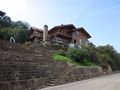
Everything here is made of porphyr, including whole houses.
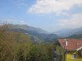
View on the Cembra valley from the main road
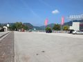
The parking lot the hash was located in
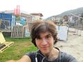
Selfie with construction material.
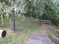
A small park on the other side of the road, hidden by trees. Cute location I must say.

My ticket to ride!
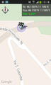
Proof from the geohash android app.


