Difference between revisions of "2014-10-28 50 7"
imported>Mirabilos |
(TIL we can do tracklogs inline and upload them even!) |
||
| (4 intermediate revisions by 3 users not shown) | |||
| Line 1: | Line 1: | ||
| − | + | [[Image:{{{image|2014-10-28 50 7 p1.jpg}}}|thumb|left]] | |
| − | |||
| − | |||
| − | |||
| − | |||
| − | |||
| − | |||
| − | |||
{{meetup graticule | {{meetup graticule | ||
| lat=50 | | lat=50 | ||
| Line 20: | Line 13: | ||
== Participants == | == Participants == | ||
| − | + | ||
| − | + | * [[User:Mirabilos|mirabilos]] ([[User talk:Mirabilos|talk]]) 1215﹟ | |
| + | * Segamaster1998 | ||
== Plans == | == Plans == | ||
| Line 30: | Line 24: | ||
== Expedition == | == Expedition == | ||
| − | + | ||
| + | Bad luck, when leaving the parking lot at work, mirabilos managed to oversee a pole and put a dent into his car ☹ | ||
| + | |||
| + | Drove picking up the second person on the tour, went to Andernach for OC2968 and collateral geodamage, drove to Koblenz to the recommended parking spot of one geocache (this is where the tracklog begins, cut off the boring part, and it ends when exiting the GPS app to start the camera app), and off we went, into the deep dark forest. | ||
| + | |||
| + | mirabilos probably should edit OSM, because the forest path was most definitely not as nice as promised, and got worse instead of better later. | ||
| + | |||
| + | Nevertheless, managed ±1m on 20:12, which is better than the GPSr normally gets. | ||
| + | |||
| + | Since ''both'' our flashlights started troubling, and my reserve one is much less powerful, we decided to cut off there and skip the geocaches in that forest, and continue to the GeoVexilla mirabilos wanted to capture, and assorted geocaches in that area, instead. Bad luck day continued with an indigestion (acid heartburn? allergy?) during food… | ||
| + | |||
| + | We did not meet any other geohashers, but that would probably have scared us more instead. | ||
== Tracklog == | == Tracklog == | ||
| − | + | {{tracklog | 2014-10-28_50_7.gpx}} | |
== Photos == | == Photos == | ||
| − | |||
| − | |||
| − | |||
<gallery perrow="5"> | <gallery perrow="5"> | ||
| + | Image:2014-10-28 50 7 p1.jpg | 1.3 Megapixels are not enough to see the marker on this photo, unfortunately. Not even in the raw. | ||
</gallery> | </gallery> | ||
== Achievements == | == Achievements == | ||
{{#vardefine:ribbonwidth|800px}} | {{#vardefine:ribbonwidth|800px}} | ||
| − | + | to be done | |
| − | |||
| − | |||
| − | |||
| − | |||
| − | |||
| − | |||
| − | |||
| − | |||
| − | |||
| − | |||
| − | |||
| − | |||
| − | |||
[[Category:Expeditions]] | [[Category:Expeditions]] | ||
| − | |||
[[Category:Expeditions with photos]] | [[Category:Expeditions with photos]] | ||
| − | |||
| − | |||
| − | |||
| − | |||
| − | |||
[[Category:Coordinates reached]] | [[Category:Coordinates reached]] | ||
| − | + | {{location|DE|RP|KO}} | |
| − | |||
| − | |||
| − | |||
| − | |||
| − | |||
| − | |||
| − | |||
| − | |||
| − | |||
| − | |||
| − | |||
| − | |||
| − | |||
| − | |||
| − | |||
| − | |||
| − | |||
| − | |||
| − | |||
| − | |||
Latest revision as of 19:32, 3 December 2021

| Tue 28 Oct 2014 in 50,7: 50.3602147, 7.6584147 geohashing.info google osm bing/os kml crox |
Location
Forest behind Koblenz-Arenberg, close to a possibly good-quality forest path.
Participants
Plans
The GZ is about 300m from the final coordinates of a mystery geocache solved, so making a trip to Koblenz to take them both, despite the gasoline costs, is not unreasonable.
This will be between about 19:00 and 21:00 CET. No idea when exactly.
Expedition
Bad luck, when leaving the parking lot at work, mirabilos managed to oversee a pole and put a dent into his car ☹
Drove picking up the second person on the tour, went to Andernach for OC2968 and collateral geodamage, drove to Koblenz to the recommended parking spot of one geocache (this is where the tracklog begins, cut off the boring part, and it ends when exiting the GPS app to start the camera app), and off we went, into the deep dark forest.
mirabilos probably should edit OSM, because the forest path was most definitely not as nice as promised, and got worse instead of better later.
Nevertheless, managed ±1m on 20:12, which is better than the GPSr normally gets.
Since both our flashlights started troubling, and my reserve one is much less powerful, we decided to cut off there and skip the geocaches in that forest, and continue to the GeoVexilla mirabilos wanted to capture, and assorted geocaches in that area, instead. Bad luck day continued with an indigestion (acid heartburn? allergy?) during food…
We did not meet any other geohashers, but that would probably have scared us more instead.
Tracklog
Photos
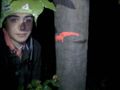
1.3 Megapixels are not enough to see the marker on this photo, unfortunately. Not even in the raw.
Achievements
to be done