Difference between revisions of "2014-11-03 47 -122"
From Geohashing
imported>Thomcat (Great location, near Trader Joes, Half Price Books and a cool new game store.) |
imported>FippeBot m (Location) |
||
| (6 intermediate revisions by 2 users not shown) | |||
| Line 18: | Line 18: | ||
== Expedition == | == Expedition == | ||
| − | + | Rained all day here in Seatown. Set off late from work, arriving in the neighborhood with many parallels to my own just before 4:00. Snapped a few pictures of the house, went to the porch to drop off a flyer/poster, then recorded my presence... | |
| − | == | + | *On the spot -- [[User:Thomcat|Thomcat]] ([[User talk:Thomcat|talk]]) [http://www.openstreetmap.org/?lat=47.82934192&lon=-122.32647596&zoom=16&layers=B000FTF @47.8293,-122.3265] 16:00, 3 November 2014 (PST) |
| − | + | ||
| + | Quick stop on the way home at [http://www.rttgamepub.com/ Round the Table]. | ||
== Photos == | == Photos == | ||
| − | |||
| − | |||
| − | |||
<gallery perrow="5"> | <gallery perrow="5"> | ||
| − | |||
| − | == | + | Image:2014-11-03_47_-122_thomcat_-1.jpg | Rain. [http://www.openstreetmap.org/?lat=47.82093542&lon=-122.28167674&zoom=16&layers=B000FTF @47.8209,-122.2817] |
| − | |||
| − | |||
| + | Image:2014-11-03_47_-122_thomcat_1415059066661.jpg | img from 12m; geohashdroid says 42m [http://www.openstreetmap.org/?lat=47.82950000&lon=-122.32600000&zoom=16&layers=B000FTF @47.8295,-122.3260] | ||
| − | [ | + | Image:2014-11-03_47_-122_thomcat_1415059268262.jpg | [http://www.openstreetmap.org/?lat=47.82930000&lon=-122.32600000&zoom=16&layers=B000FTF @47.8293,-122.3260] |
| + | </gallery> | ||
| − | |||
[[Category:Expeditions]] | [[Category:Expeditions]] | ||
| − | |||
[[Category:Expeditions with photos]] | [[Category:Expeditions with photos]] | ||
| − | |||
| − | |||
| − | |||
| − | |||
| − | |||
[[Category:Coordinates reached]] | [[Category:Coordinates reached]] | ||
| − | + | {{location|US|WA|SN}} | |
| − | |||
| − | |||
| − | |||
| − | |||
| − | |||
| − | |||
| − | |||
| − | |||
| − | |||
| − | |||
| − | |||
| − | |||
| − | |||
| − | |||
| − | |||
| − | |||
| − | |||
Latest revision as of 01:53, 15 August 2019
| Mon 3 Nov 2014 in Seattle: 47.8293835, -122.3265310 geohashing.info google osm bing/os kml crox |
Location
Someones front yard off Blue Ridge Drive in Lynnwood.
Participants
Plans
Stop by after work, early afternoon. Examine how their Blue Ridge compares to the one I live near. Issue a Lynnwood challenge for A Tale of Two Hashes (very surprised there wasn't one).
Expedition
Rained all day here in Seatown. Set off late from work, arriving in the neighborhood with many parallels to my own just before 4:00. Snapped a few pictures of the house, went to the porch to drop off a flyer/poster, then recorded my presence...
- On the spot -- Thomcat (talk) @47.8293,-122.3265 16:00, 3 November 2014 (PST)
Quick stop on the way home at Round the Table.
Photos
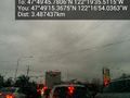
Rain. @47.8209,-122.2817
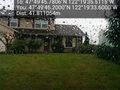
img from 12m; geohashdroid says 42m @47.8295,-122.3260


