Difference between revisions of "2014-11-19 52 -1"
imported>Pbro (→Participants) |
imported>FippeBot m (Location) |
||
| (11 intermediate revisions by 2 users not shown) | |||
| Line 17: | Line 17: | ||
<!-- edit as necessary --> | <!-- edit as necessary --> | ||
__NOTOC__ | __NOTOC__ | ||
| + | |||
| + | [[User:Pbro|Pbro]] ([[User talk:Pbro|talk]]) went for a run and found a hash. | ||
| + | |||
== Location == | == Location == | ||
58 Cheveral Avenue, Radford, Coventry CV6 3EE. Right at the edge of the pavement. | 58 Cheveral Avenue, Radford, Coventry CV6 3EE. Right at the edge of the pavement. | ||
== Participants == | == Participants == | ||
| − | [[User:Pbro|Pbro]] ([[User talk:Pbro|talk]]) | + | [[User:Pbro|Pbro]] ([[User talk:Pbro|talk]]) – going for an evening run. |
== Plans == | == Plans == | ||
| − | + | The original plan was to make a 6 km detour on the bicycle ride home, but I could not justify returning home later for that. But changing the route of my run later that day. So I set out with GPS watch and mobile to document this exhibition. | |
== Expedition == | == Expedition == | ||
| − | + | Came home, entertained my family for some time, partially recharged my mobile, changed into my running gear, and set out. I have not yet been running in that area. On the way, my dated smartphone refused to get a GPS lock at some point, and needed pleading and cajoling. But after just over 3 km, I arrived at that day's hash mark. It took some time to get a proper high quality GPS lock, but I managed to get a screenshot at the right time. | |
| + | |||
| + | I did not have anything with me except my phone and a Garmin Forerunner 310XT, so I could not leave a poster. Also, the two pictures I took suffer from inferior lighting (at 7pm it's well after dark). After loitering around for a while (it's such a quiet neighbourhood, that I worried somebody would call the police on me for suspicious activity – fiddling around on a mobile, walking past the same house forever...) I started on the return trip, only to notice that I forgot to mark the location in my watch. That added another couple of minutes to my trip, but after another 3 k I was back home. | ||
== Tracklog == | == Tracklog == | ||
| − | + | [http://connect.garmin.com/modern/activity/636163849 Garmin Connect Track log] | |
== Photos == | == Photos == | ||
| − | |||
| − | |||
| − | |||
<gallery perrow="5"> | <gallery perrow="5"> | ||
| + | Image:2014-11-19 52 -1 GPS screenshot.png | See GPS eating my mobile battery. | ||
| + | Image:2014-11-19 52 -1 Portrait.jpg | Lo-res selfie under the nearest streetlight. | ||
</gallery> | </gallery> | ||
== Achievements == | == Achievements == | ||
{{#vardefine:ribbonwidth|800px}} | {{#vardefine:ribbonwidth|800px}} | ||
| − | + | {{Walk geohash | |
| + | | latitude = 52 | ||
| + | | longitude = -1 | ||
| + | | date = 2014-11-19 | ||
| + | | name = [[User:Pbro|Pbro]] | ||
| + | | image = 2014-11-19 52 -1 Portrait.jpg | ||
| + | | distance = 6.52 km | ||
| − | + | }} | |
| − | + | {{land geohash | |
| − | |||
| − | + | | latitude = 52 | |
| + | | longitude = -1 | ||
| + | | date = 2014-11-19 | ||
| + | | name = [[User:Pbro|Pbro]] | ||
| + | | image = 2014-11-19 52 -1 Portrait.jpg | ||
| − | + | }} | |
| − | |||
| − | |||
| − | |||
| − | + | {{Two to the N achievement | |
| + | |||
| + | | count = 0 | ||
| + | | date = 2014-11-19 | ||
| + | | latitude = 52 | ||
| + | | longitude = -1 | ||
| + | | reached = true | ||
| + | | name = [[User:Pbro|Pbro]] | ||
| + | |||
| + | }} | ||
[[Category:Expeditions]] | [[Category:Expeditions]] | ||
| − | |||
[[Category:Expeditions with photos]] | [[Category:Expeditions with photos]] | ||
| − | |||
| − | |||
| − | |||
| − | |||
| − | |||
[[Category:Coordinates reached]] | [[Category:Coordinates reached]] | ||
| − | + | {{location|GB|ENG|COV}} | |
| − | |||
| − | |||
| − | |||
| − | |||
| − | |||
| − | |||
| − | |||
| − | |||
| − | |||
| − | |||
| − | |||
| − | |||
| − | |||
| − | |||
| − | |||
| − | |||
| − | |||
Latest revision as of 02:00, 15 August 2019
| Wed 19 Nov 2014 in 52,-1: 52.4226984, -1.5185215 geohashing.info google osm bing/os kml crox |
Pbro (talk) went for a run and found a hash.
Location
58 Cheveral Avenue, Radford, Coventry CV6 3EE. Right at the edge of the pavement.
Participants
Pbro (talk) – going for an evening run.
Plans
The original plan was to make a 6 km detour on the bicycle ride home, but I could not justify returning home later for that. But changing the route of my run later that day. So I set out with GPS watch and mobile to document this exhibition.
Expedition
Came home, entertained my family for some time, partially recharged my mobile, changed into my running gear, and set out. I have not yet been running in that area. On the way, my dated smartphone refused to get a GPS lock at some point, and needed pleading and cajoling. But after just over 3 km, I arrived at that day's hash mark. It took some time to get a proper high quality GPS lock, but I managed to get a screenshot at the right time.
I did not have anything with me except my phone and a Garmin Forerunner 310XT, so I could not leave a poster. Also, the two pictures I took suffer from inferior lighting (at 7pm it's well after dark). After loitering around for a while (it's such a quiet neighbourhood, that I worried somebody would call the police on me for suspicious activity – fiddling around on a mobile, walking past the same house forever...) I started on the return trip, only to notice that I forgot to mark the location in my watch. That added another couple of minutes to my trip, but after another 3 k I was back home.
Tracklog
Photos
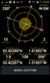
See GPS eating my mobile battery.
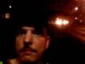
Lo-res selfie under the nearest streetlight.


Achievements
Pbro earned the Walk geohash Achievement
|
Pbro earned the Land geohash achievement
|
