Difference between revisions of "2014-12-03 41 -71"
imported>Vbob (Created page with "{{subst:Expedition |lat = latitude of graticule |lon = longitude of graticule |date = date of expedition, in YYYY-MM-DD format }}") |
imported>FippeBot m (Location) |
||
| (21 intermediate revisions by 3 users not shown) | |||
| Line 10: | Line 10: | ||
--> | --> | ||
{{meetup graticule | {{meetup graticule | ||
| − | | lat= | + | | lat=41 |
| − | | lon= | + | | lon=-71 |
| − | | date= | + | | date=2014-12-03 |
}} | }} | ||
| Line 19: | Line 19: | ||
== Location == | == Location == | ||
<!-- where you've surveyed the hash to be --> | <!-- where you've surveyed the hash to be --> | ||
| + | Seems to be right between the two southbound lanes of North Main Street, Providence, RI USA, on the south side of the intersection with Rochambeau Avenue. | ||
== Participants == | == Participants == | ||
<!-- who attended: If you link to your wiki user name in this section, your expedition will be picked up by the various statistics generated for geohashing. You may use three tildes ~ as a shortcut to automatically insert the user signature of the account you are editing with. | <!-- who attended: If you link to your wiki user name in this section, your expedition will be picked up by the various statistics generated for geohashing. You may use three tildes ~ as a shortcut to automatically insert the user signature of the account you are editing with. | ||
--> | --> | ||
| + | |||
| + | [[User:Vbob|Vbob]] | ||
| + | |||
| + | [[User:ChrisG|ChrisG]] | ||
== Plans == | == Plans == | ||
<!-- what were the original plans --> | <!-- what were the original plans --> | ||
| + | Go there on the ride home. If traffic permits, try for Speed Racer. If stopped at traffic light immediately north, probably can't get up to speed limit before reaching the hash. | ||
| + | |||
| + | ChrisG: Happened to look at my phone for today's location, and shocked that 1) it's 379.37 meters from my couch, and 2) I'm not going to be the first person here today. It's 10:20PM, and I'm heading out. Somehow, Mrs ChrisG understands why I'm going out. | ||
== Expedition == | == Expedition == | ||
<!-- how it all turned out. your narrative goes here. --> | <!-- how it all turned out. your narrative goes here. --> | ||
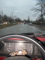
| + | Rainy day and a busy street - drove through the intersection just a bit below the 25 MPH speed limit, which was really scary because NOBODY else was going that slow. Pulled over at a nearby bus stop and walked back to stand still long enough for my Garmin to settle down and take a few photos. I've driven through this intersection at least twice a week for the last 30 years, but hardly ever at the speed limit.... | ||
| + | |||
| + | ChrisG: A nice brisk walk. Traffic was light, but still somehow playing in traffic isn't easy... but I guess it's easier than having to traipse through the cemetery that's 50 meters from the hashpoint. I took a screencap of my GPS while standing in the middle of the road, and pics from the sidewalk. Unless there's a couch point, it'll never be easier than tonight. | ||
== Tracklog == | == Tracklog == | ||
| Line 38: | Line 49: | ||
--> | --> | ||
<gallery perrow="5"> | <gallery perrow="5"> | ||
| + | Image:2014-12-03_41_-71_a_.jpg | Vbob and Nameless Hashcot rolling through the hash point | ||
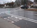
| + | Image:2014-12-03_41_-71_b_.jpg | Looking back at hashpoint just on other side of crosswalk | ||
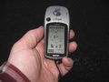
| + | Image:2014-12-03_41_-71_c_.jpg | Google Maps and Garmin eTrex don't agree very well, but it was much too dangerous to do the GPS dance in traffic... | ||
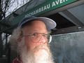
| + | Image:2014-12-03_41_-71_d_.jpg | you call that a grin? | ||
| + | |||
| + | Image:2014-12-03_41_-71_ChrisG_1417664200313.jpg | Got the walking badge! [http://www.openstreetmap.org/?lat=41.84678924&lon=-71.40532948&zoom=16&layers=B000FTF @41.8468,-71.4053] | ||
| + | |||
| + | Image:2014-12-03_41_-71_ChrisG_1417664224570.jpg | Could have taken the bus. [http://www.openstreetmap.org/?lat=41.84681606&lon=-71.40532825&zoom=16&layers=B000FTF @41.8468,-71.4053] | ||
| + | |||
| + | Image:2014-12-03_41_-71_ChrisG_1417664156000.jpg | | ||
</gallery> | </gallery> | ||
| Line 43: | Line 64: | ||
{{#vardefine:ribbonwidth|800px}} | {{#vardefine:ribbonwidth|800px}} | ||
<!-- Add any achievement ribbons you earned below, or remove this section --> | <!-- Add any achievement ribbons you earned below, or remove this section --> | ||
| + | {{Speed racer | ||
| + | | latitude = 41 | ||
| + | | longitude = -71 | ||
| + | | date = 2014-12-03 | ||
| + | | name = Vbob | ||
| + | | speed = nearly 25 MPH | ||
| + | }} | ||
| + | {{Walk geohash | ||
| + | | latitude = 41 | ||
| + | | longitude = -71 | ||
| + | | date = 2014-12-03 | ||
| + | | name = [[User:ChrisG|ChrisG]] | ||
| + | }} | ||
| − | |||
| − | |||
| − | |||
| − | |||
| − | |||
| − | |||
| − | |||
| − | |||
| − | |||
| − | |||
| − | |||
[[Category:Expeditions]] | [[Category:Expeditions]] | ||
| − | |||
[[Category:Expeditions with photos]] | [[Category:Expeditions with photos]] | ||
| − | |||
| − | |||
| − | |||
| − | |||
| − | |||
[[Category:Coordinates reached]] | [[Category:Coordinates reached]] | ||
| − | + | {{location|US|RI|PR}} | |
| − | |||
| − | |||
| − | |||
| − | |||
| − | |||
| − | |||
| − | |||
| − | |||
| − | |||
| − | |||
| − | |||
| − | |||
| − | |||
| − | |||
| − | |||
| − | |||
| − | |||
Latest revision as of 02:07, 15 August 2019
| Wed 3 Dec 2014 in 41,-71: 41.8467716, -71.4052240 geohashing.info google osm bing/os kml crox |
Location
Seems to be right between the two southbound lanes of North Main Street, Providence, RI USA, on the south side of the intersection with Rochambeau Avenue.
Participants
Plans
Go there on the ride home. If traffic permits, try for Speed Racer. If stopped at traffic light immediately north, probably can't get up to speed limit before reaching the hash.
ChrisG: Happened to look at my phone for today's location, and shocked that 1) it's 379.37 meters from my couch, and 2) I'm not going to be the first person here today. It's 10:20PM, and I'm heading out. Somehow, Mrs ChrisG understands why I'm going out.
Expedition
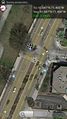
Rainy day and a busy street - drove through the intersection just a bit below the 25 MPH speed limit, which was really scary because NOBODY else was going that slow. Pulled over at a nearby bus stop and walked back to stand still long enough for my Garmin to settle down and take a few photos. I've driven through this intersection at least twice a week for the last 30 years, but hardly ever at the speed limit....
ChrisG: A nice brisk walk. Traffic was light, but still somehow playing in traffic isn't easy... but I guess it's easier than having to traipse through the cemetery that's 50 meters from the hashpoint. I took a screencap of my GPS while standing in the middle of the road, and pics from the sidewalk. Unless there's a couch point, it'll never be easier than tonight.
Tracklog
Photos
Vbob and Nameless Hashcot rolling through the hash point
Looking back at hashpoint just on other side of crosswalk
Google Maps and Garmin eTrex don't agree very well, but it was much too dangerous to do the GPS dance in traffic...
you call that a grin?
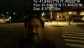
Got the walking badge! @41.8468,-71.4053
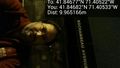
Could have taken the bus. @41.8468,-71.4053


Achievements

ChrisG earned the Walk geohash Achievement
|