Difference between revisions of "2014-12-13 44 11"
imported>Kleon (Created page with "{{subst:Expedition |lat = 44 |lon = 11 |date = 2014-12-13 }}") |
m (Location correction) |
||
| (6 intermediate revisions by 3 users not shown) | |||
| Line 19: | Line 19: | ||
== Location == | == Location == | ||
<!-- where you've surveyed the hash to be --> | <!-- where you've surveyed the hash to be --> | ||
| + | |||
| + | A hill in close proximity of Paderno: a small town on the hills near Bologna. | ||
== Participants == | == Participants == | ||
| Line 24: | Line 26: | ||
--> | --> | ||
| − | + | [[User:Kleon|Kleon]] and a few friends who haven't made accounts yet. I don't think they will even read this. Hi Lorenzo! | |
| − | |||
== Expedition == | == Expedition == | ||
<!-- how it all turned out. your narrative goes here. --> | <!-- how it all turned out. your narrative goes here. --> | ||
| + | |||
| + | We met in Bologna and Alberto drove us to Paderno. From there we walked along the border of a field until we found a spot to cross a creek. After walking for a little in the woods (there were many tracks of wild animals that distracted me along the way), we found a path that brought us into a range of 30 meters from the hash. It was on the side of a hill without much vegetation. | ||
| + | After taking some photos we got back following the path we had found previously until we got back to the street. | ||
== Tracklog == | == Tracklog == | ||
<!-- if your GPS device keeps a log, you may post a link here --> | <!-- if your GPS device keeps a log, you may post a link here --> | ||
| + | |||
| + | [http://www.gpsies.com/map.do?fileId=yheezmtxnggzzqbk tracklog here] | ||
== Photos == | == Photos == | ||
| Line 38: | Line 44: | ||
--> | --> | ||
<gallery perrow="5"> | <gallery perrow="5"> | ||
| + | Image:2014_12_13_44_11_stream.JPG|After walking in the muddy field we had to cross a small stream of water (also if you look closely you may spot a wild Alberto!) | ||
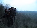
| + | Image:2014_12_13_44_11_woods.JPG|Us getting through the woods. | ||
| + | Image:2014_12_13_44_11_view01.JPG|The view from the path we've found. | ||
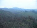
| + | Image:2014_12_13_44_11_view02.JPG|The hill next to our geohash. | ||
| + | Image:2014_12_13_44_11_view03.JPG|The panorama from the hash. | ||
| + | Image:2014_12_13_44_11_us_at_geohash.JPG|Us at the geohash. | ||
| + | Image:2014_12_13_44_11_stupid_grin.JPG|us at the location featuring the Stupid Grin™ | ||
| + | Image:2014_12_13_44_11_gps_at_geohash.JPG|Alberto's GPS device at the geohash. | ||
| + | Image:2014_12_13_44_11_mark.JPG|The sign we left. | ||
</gallery> | </gallery> | ||
| Line 43: | Line 58: | ||
{{#vardefine:ribbonwidth|800px}} | {{#vardefine:ribbonwidth|800px}} | ||
<!-- Add any achievement ribbons you earned below, or remove this section --> | <!-- Add any achievement ribbons you earned below, or remove this section --> | ||
| + | {{land geohash| latitude = 44 | longitude = 11 | date = 2014-12-13 | name = Kleon}} | ||
| − | |||
| − | |||
| − | |||
| − | |||
| − | |||
| − | |||
| − | |||
| − | |||
| − | |||
| − | |||
| − | |||
| − | |||
| − | |||
[[Category:Expeditions]] | [[Category:Expeditions]] | ||
| − | + | [[Category:Coordinates reached]] | |
[[Category:Expeditions with photos]] | [[Category:Expeditions with photos]] | ||
| − | + | {{location|IT|ER}} | |
| − | |||
| − | |||
| − | |||
| − | |||
| − | |||
| − | |||
| − | |||
| − | |||
| − | |||
| − | |||
| − | |||
| − | |||
| − | |||
| − | |||
| − | |||
| − | |||
| − | |||
| − | |||
| − | |||
| − | |||
| − | |||
| − | |||
| − | |||
Latest revision as of 15:12, 28 July 2021
| Sat 13 Dec 2014 in 44,11: 44.4419590, 11.3161601 geohashing.info google osm bing/os kml crox |
Location
A hill in close proximity of Paderno: a small town on the hills near Bologna.
Participants
Kleon and a few friends who haven't made accounts yet. I don't think they will even read this. Hi Lorenzo!
Expedition
We met in Bologna and Alberto drove us to Paderno. From there we walked along the border of a field until we found a spot to cross a creek. After walking for a little in the woods (there were many tracks of wild animals that distracted me along the way), we found a path that brought us into a range of 30 meters from the hash. It was on the side of a hill without much vegetation. After taking some photos we got back following the path we had found previously until we got back to the street.
Tracklog
Photos
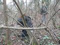
After walking in the muddy field we had to cross a small stream of water (also if you look closely you may spot a wild Alberto!)
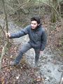
Us getting through the woods.
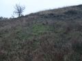
The view from the path we've found.
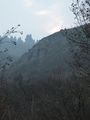
The hill next to our geohash.
The panorama from the hash.
Us at the geohash.
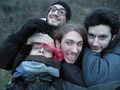
us at the location featuring the Stupid Grin™
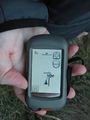
Alberto's GPS device at the geohash.

The sign we left.


Achievements
Kleon earned the Land geohash achievement
|