Difference between revisions of "2015-01-01 49 8"
From Geohashing
imported>DODO (→Participants) |
m (Location correction) |
||
| (7 intermediate revisions by 2 users not shown) | |||
| Line 28: | Line 28: | ||
== Plans == | == Plans == | ||
<!-- what were the original plans --> | <!-- what were the original plans --> | ||
| + | I will walk there. Start at 15:30, so I hope to arrive between 4 and 4:30. | ||
== Expedition == | == Expedition == | ||
<!-- how it all turned out. your narrative goes here. --> | <!-- how it all turned out. your narrative goes here. --> | ||
| + | Just as planned: a nice 90 minutes -tron - walk to cure my hangover. I came along a place that I like very much, the [http://de.wikipedia.org/wiki/Standortübungsplatz_Speyer Speyrer Düne] (dune of Speyer). | ||
| + | |||
| + | The hash was easy to find, just 10m of my way. I took some photos, made an x with sticks (but forgot to take a picture of that) and went home. As I know the surroundings quite good, I tried a ton, and I think, I succeeded. | ||
== Tracklog == | == Tracklog == | ||
<!-- if your GPS device keeps a log, you may post a link here --> | <!-- if your GPS device keeps a log, you may post a link here --> | ||
| + | [http://www.gpsies.com/map.do?fileId=bsqpismwkudpaaap 9,3 KM by foot] | ||
== Photos == | == Photos == | ||
| Line 40: | Line 45: | ||
--> | --> | ||
<gallery perrow="5"> | <gallery perrow="5"> | ||
| + | Image:2015-01-01_49_8-1.jpg|Speyrer Düne | ||
| + | Image:2015-01-01_49_8-2.jpg|Der Ameisenhügel (the ants hill), the highest dune in Speyer | ||
| + | Image:2015-01-01_49_8-3.jpg|I obviously left the teritory of Speyer | ||
| + | Image:2015-01-01_49_8-4.jpg|proof | ||
| + | Image:2015-01-01_49_8-5.jpg|at the hashpoint | ||
| + | Image:2015-01-01_49_8-6.jpg|the path is just a few meters from the hashpoint | ||
| + | Image:2015-01-01_49_8-7.jpg|stupid grin | ||
</gallery> | </gallery> | ||
| Line 46: | Line 58: | ||
<!-- Add any achievement ribbons you earned below, or remove this section --> | <!-- Add any achievement ribbons you earned below, or remove this section --> | ||
| + | {{land geohash | ||
| + | |||
| + | | latitude = 49 | ||
| + | | longitude = 8 | ||
| + | | date = 2015-01-01 | ||
| + | | name = DODO | ||
| + | }} | ||
| − | + | {{Walk geohash | |
| − | + | | latitude = 49 | |
| − | + | | longitude = 8 | |
| + | | date = 2015-01-01 | ||
| + | | name = DODO | ||
| + | | distance = 9,3 KM | ||
| + | | image=2015-01-01 49 8-2.jpg | ||
| + | }} | ||
| − | + | {{Template:Tron | |
| + | | latitude = 49 | ||
| + | | longitude = 8 | ||
| + | | date = 2015-01-01 | ||
| + | | name = DODO | ||
| + | | possessive = his | ||
| + | | tracklog = http://www.gpsies.com/map.do?fileId=bsqpismwkudpaaap | ||
| + | }} | ||
| − | |||
| − | |||
| − | |||
| − | |||
| − | |||
[[Category:Expeditions]] | [[Category:Expeditions]] | ||
| − | |||
[[Category:Expeditions with photos]] | [[Category:Expeditions with photos]] | ||
| − | |||
| − | |||
| − | |||
| − | |||
| − | |||
[[Category:Coordinates reached]] | [[Category:Coordinates reached]] | ||
| − | + | {{location|DE|RP|RP}} | |
| − | |||
| − | |||
| − | |||
| − | |||
| − | |||
| − | |||
| − | |||
| − | |||
| − | |||
| − | |||
| − | |||
| − | |||
| − | |||
| − | |||
| − | |||
| − | |||
| − | |||
Latest revision as of 20:27, 16 May 2020
| Thu 1 Jan 2015 in 49,8: 49.3362715, 8.3794324 geohashing.info google osm bing/os kml crox |
Location
In the forest near Speyer, just 4 KM from DODOs home.
Participants
Plans
I will walk there. Start at 15:30, so I hope to arrive between 4 and 4:30.
Expedition
Just as planned: a nice 90 minutes -tron - walk to cure my hangover. I came along a place that I like very much, the Speyrer Düne (dune of Speyer).
The hash was easy to find, just 10m of my way. I took some photos, made an x with sticks (but forgot to take a picture of that) and went home. As I know the surroundings quite good, I tried a ton, and I think, I succeeded.
Tracklog
Photos
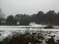
Speyrer Düne
Der Ameisenhügel (the ants hill), the highest dune in Speyer
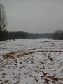
I obviously left the teritory of Speyer
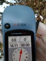
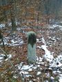
proof
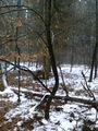
at the hashpoint
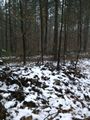
the path is just a few meters from the hashpoint

stupid grin


Achievements
DODO earned the Land geohash achievement
|
DODO earned the Walk geohash Achievement
|
DODO earned the Tron achievement
|