2015-01-09 52 0
From Geohashing
Revision as of 14:16, 14 January 2015 by imported>Sourcerer (→Added Achievement)
| Fri 9 Jan 2015 in 52,0: 52.1155893, 0.4228284 geohashing.info google osm bing/os kml crox |
Location
Between Withersfield and Temple End north of Haverhill, Suffolk, UK.
Participants
Expedition
- Arrived. -- Sourcerer (talk) @52.1156,.4229 15:12, 9 January 2015 (GMT)
On impulse, I set out on the quest to find the hashpoint. It was in the middle of a soggy puddle on a public footpath. Most rewarding. The weather was dull, mild and breezy and unusually warm for January. The wind was due to explosive cyclogenesis causing 100 mph winds in the North of Scotland. Fortunately the wind was less in Suffolk but it is howling in the chimney as I write this.
Photos

@52.1156,.4229 and proof
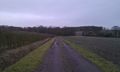
The Approach
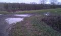
The Hashpoint


Achievements
Sourcerer earned the OpenStreetMap achievement
|
Other geohashing expeditions on the same day
Expeditions and Plans
| 2015-01-09 | ||
|---|---|---|
| Cambridge, United Kingdom | Sourcerer | Between Withersfield and Temple End north of Haverhill, Suffolk, UK. |