2015-01-10 52 1
| Sat 10 Jan 2015 in 52,1: 52.7254662, 1.4416680 geohashing.info google osm bing/os kml crox |
Location
In a harvested sugar beet field at Cangate, Norfolk, UK.
Participants
Expedition
- Arrived -- Sourcerer (talk) @52.7254,1.4417 14:25, 10 January 2015 (GMT)
Sourcerer waited for a cold front to pass through with squall winds, rain and hail. Later it was sunny but still very breezy with quite a chill factor but well above freezing. This was bracing walking weather. The hashpoint was easily reached. It was 17 metres from the field perimeter path. In the distance, poly-tunnel frames were visible with no polythene. Underneath were overwintering strawberries. In the spring, the covering is added to get an earlier crop.
The hardest feature of this expedition was finding somewhere off-road to park the car. There had been a lot of rain and all the potential parking places looked wet and muddy, ideal to get stuck. Eventually a spot was located and no main-road walking would be needed.
Photos
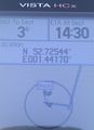
The Proof
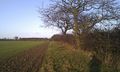
The Location

Frozen Selfie


