Difference between revisions of "2015-01-27 47 -122"
imported>Thomcat (Seattle expedition) |
imported>FippeBot m (Location) |
||
| (8 intermediate revisions by one other user not shown) | |||
| Line 18: | Line 18: | ||
== Expedition == | == Expedition == | ||
| − | + | This location is northeast of where I work, and while not "on the way" is certainly not too far off the track. | |
| + | |||
| + | Aerial imagery research on Google show a mostly undeveloped area; Bing has it completely undeveloped. Based on their [http://wa-snohomishcounty.civicplus.com/DocumentCenter/View/8874 website] there has been significant work in the area. Looking forward to checking it out. | ||
| + | |||
| + | As pictured on the above map, there is indeed a circular parking area with plenty of spots. The playground looks decent, though it's mostly new-fangled equipment. I found a nice parking spot and snapped a picture of a dedication plaque and a nice bridge over the Tambark creek. | ||
| + | |||
| + | While taking my photo I heard the distinctive rat-tat of a woodpecker. This guy has a red crest above a white band. When I tried to approach closer, he moved to the other side of the tree -- camera shy I guess. | ||
| + | |||
| + | I then got to the business of finding the hashpoint, hoping it wasn't in the creek. Fortunately it was just shy of the creek in a nicely cleared area that has some bushes and small trees planted. In another year or two, this hashpoint will be considerably more difficult to reach. | ||
| + | |||
| + | Snapped a picture on the spot and a panorama to follow. I then made my way out and visited the off-leash dog area. No dog with me today, and it looked pretty muddy besides. Satisfied with success, I headed off to work. | ||
== Tracklog == | == Tracklog == | ||
| Line 28: | Line 38: | ||
--> | --> | ||
<gallery perrow="5"> | <gallery perrow="5"> | ||
| − | |||
| − | == | + | Image:2015-01-27_47_-122_thomcat_1422377143314.jpg | [http://www.openstreetmap.org/?lat=47.84026807&lon=-122.18469490&zoom=16&layers=B000FTF @47.8403,-122.1847] |
| − | |||
| − | |||
| + | Image:2015-01-27_47_-122_thomcat_1422377259824.jpg | [http://www.openstreetmap.org/?lat=47.84098791&lon=-122.18413048&zoom=16&layers=B000FTF @47.8410,-122.1841] | ||
| − | [ | + | Image:2015-01-27_47_-122_thomcat_1422377335020.jpg | Woodpecker [http://www.openstreetmap.org/?lat=47.84120577&lon=-122.18437478&zoom=16&layers=B000FTF @47.8412,-122.1844] |
| − | + | Image:2015-01-27_47_-122_thomcat_1422377550754.jpg | [http://www.openstreetmap.org/?lat=47.84118588&lon=-122.18465519&zoom=16&layers=B000FTF @47.8412,-122.1847] | |
| − | |||
| − | -- | ||
| − | [ | ||
| − | |||
| − | |||
| − | |||
| − | |||
| − | |||
| − | |||
| + | Image:2015-01-27_47_-122_thomcat_1422377827368.jpg | Panorama [http://www.openstreetmap.org/?lat=47.84117734&lon=-122.18470500&zoom=16&layers=B000FTF @47.8412,-122.1847] | ||
| − | + | Image:2015-01-27_47_-122_thomcat_1422377963648.jpg | [http://www.openstreetmap.org/?lat=47.84118900&lon=-122.18468339&zoom=16&layers=B000FTF @47.8412,-122.1847] | |
| − | |||
| − | -- | ||
| − | |||
| − | |||
| − | |||
| − | |||
| − | |||
| − | + | Image:2015-01-27_47_-122_thomcat_1422378130240.jpg | Off leash dog area [http://www.openstreetmap.org/?lat=47.84131628&lon=-122.18368899&zoom=16&layers=B000FTF @47.8413,-122.1837] | |
| − | + | </gallery> | |
| − | |||
| − | |||
| − | |||
| − | + | [[Category:Expeditions]] | |
| + | [[Category:Expeditions with photos]] | ||
| + | [[Category:Coordinates reached]] | ||
| + | {{location|US|WA|SN}} | ||
Latest revision as of 02:34, 15 August 2019
| Tue 27 Jan 2015 in Seattle: 47.8411961, -122.1846586 geohashing.info google osm bing/os kml crox |
Location
Northwest section of Tambark Creek Park, off 35th Ave SE near Mill Creek.
Participants
Plans
Quick stop in the morning to survey the scene. Possible return (meetup?) in the afternoon.
Expedition
This location is northeast of where I work, and while not "on the way" is certainly not too far off the track.
Aerial imagery research on Google show a mostly undeveloped area; Bing has it completely undeveloped. Based on their website there has been significant work in the area. Looking forward to checking it out.
As pictured on the above map, there is indeed a circular parking area with plenty of spots. The playground looks decent, though it's mostly new-fangled equipment. I found a nice parking spot and snapped a picture of a dedication plaque and a nice bridge over the Tambark creek.
While taking my photo I heard the distinctive rat-tat of a woodpecker. This guy has a red crest above a white band. When I tried to approach closer, he moved to the other side of the tree -- camera shy I guess.
I then got to the business of finding the hashpoint, hoping it wasn't in the creek. Fortunately it was just shy of the creek in a nicely cleared area that has some bushes and small trees planted. In another year or two, this hashpoint will be considerably more difficult to reach.
Snapped a picture on the spot and a panorama to follow. I then made my way out and visited the off-leash dog area. No dog with me today, and it looked pretty muddy besides. Satisfied with success, I headed off to work.
Tracklog
Photos
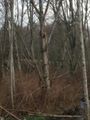
Woodpecker @47.8412,-122.1844
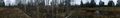
Panorama @47.8412,-122.1847
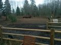
Off leash dog area @47.8413,-122.1837


