Difference between revisions of "2015-01-29 52 0"
From Geohashing
imported>Sourcerer m ([live] Arrived.) |
imported>FippeBot m (Location) |
||
| (11 intermediate revisions by one other user not shown) | |||
| Line 1: | Line 1: | ||
| − | |||
| − | |||
| − | |||
| − | |||
| − | |||
| − | |||
| − | |||
| − | |||
| − | |||
| − | |||
{{meetup graticule | {{meetup graticule | ||
| lat=52 | | lat=52 | ||
| lon=0 | | lon=0 | ||
| date=2015-01-29 | | date=2015-01-29 | ||
| + | | graticule_name=Cambridge, UK | ||
| + | | graticule_link=Cambridge, United Kingdom | ||
}} | }} | ||
| − | |||
| − | |||
__NOTOC__ | __NOTOC__ | ||
== Location == | == Location == | ||
| − | + | ||
| + | At midnight in a field between Hadley and Ipswich, Suffolk, UK. | ||
== Participants == | == Participants == | ||
| − | |||
| − | |||
| − | + | [[User:Sourcerer|Sourcerer]] | |
| − | |||
== Expedition == | == Expedition == | ||
| − | |||
| + | *Arrived. -- [[User:Sourcerer|Sourcerer]] ([[User talk:Sourcerer|talk]]) [http://www.openstreetmap.org/?lat=52.06409633&lon=.98478913&zoom=16&layers=B000FTF @52.0641,.9848] 00:02, 29 January 2015 (GMT) | ||
| − | + | I approached the circle of uncertainty just as midnight struck. My droid reported the expedition at two minutes past the hour. | |
| − | + | ||
| − | + | There was a place to park, under the village sign and a public footpath led close to the hashpoint. A short walk across the field led straight to the hashpoint. | |
| + | |||
| + | The midnight attempt was because the hashpoint from yesterday was only 5 or 6 km away so it was a no brainer to make a double hash (consecutive). | ||
== Photos == | == Photos == | ||
| − | + | ||
| − | |||
| − | |||
<gallery perrow="5"> | <gallery perrow="5"> | ||
| + | Image:2015-01-29 52 0 Sourcerer 0.jpg | Track reconstruction | ||
| + | Image:2015-01-29 52 0 Sourcerer 1.jpg | Proof | ||
</gallery> | </gallery> | ||
== Achievements == | == Achievements == | ||
{{#vardefine:ribbonwidth|800px}} | {{#vardefine:ribbonwidth|800px}} | ||
| − | |||
| + | {{OpenStreetMap achievement | ||
| + | | latitude = 52 | ||
| + | | longitude = 0 | ||
| + | | date = 2015-01-29 | ||
| + | | OSMlink = 28471273 | ||
| + | | name = Sourcerer | ||
| + | }} | ||
| + | {{Midnight geohash | ||
| + | | latitude = 52 | ||
| + | | longitude = 0 | ||
| + | | date = 2015-01-29 | ||
| + | | name = Sourcerer | ||
| + | }} | ||
| + | {{Last man standing | ||
| + | | latitude = 52 | ||
| + | | longitude = 0 | ||
| + | | date = 2015-01-29 | ||
| + | | gender = man | ||
| + | | name = Sourcerer | ||
| + | }} | ||
| − | + | {{Sourcerer_links | |
| − | + | | prev = 2015-01-28 52 1 | |
| − | + | | curr = 2015-01-29 52 0 | |
| − | + | | next = 2015-01-30 52 1 | |
| − | + | | date = 2015-01-29 | |
| − | + | }} | |
| − | |||
| − | |||
| − | |||
| − | |||
| − | |||
[[Category:Expeditions]] | [[Category:Expeditions]] | ||
| − | |||
[[Category:Expeditions with photos]] | [[Category:Expeditions with photos]] | ||
| − | |||
| − | |||
| − | |||
| − | |||
| − | |||
[[Category:Coordinates reached]] | [[Category:Coordinates reached]] | ||
| − | + | {{location|GB|ENG|SFK}} | |
| − | |||
| − | |||
| − | |||
| − | |||
| − | |||
| − | |||
| − | |||
| − | |||
| − | |||
| − | |||
| − | |||
| − | |||
| − | |||
| − | |||
| − | |||
| − | |||
| − | |||
Latest revision as of 02:35, 15 August 2019
| Thu 29 Jan 2015 in Cambridge, UK: 52.0641200, 0.9847686 geohashing.info google osm bing/os kml crox |
Location
At midnight in a field between Hadley and Ipswich, Suffolk, UK.
Participants
Expedition
- Arrived. -- Sourcerer (talk) @52.0641,.9848 00:02, 29 January 2015 (GMT)
I approached the circle of uncertainty just as midnight struck. My droid reported the expedition at two minutes past the hour.
There was a place to park, under the village sign and a public footpath led close to the hashpoint. A short walk across the field led straight to the hashpoint.
The midnight attempt was because the hashpoint from yesterday was only 5 or 6 km away so it was a no brainer to make a double hash (consecutive).
Photos
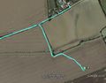
Track reconstruction
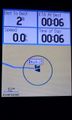
Proof


Achievements
Sourcerer earned the OpenStreetMap achievement
|
Sourcerer earned the Midnight Geohash achievement
|
Sourcerer earned the Last man standing achievement
|
Expeditions and Plans
| 2015-01-29 | ||
|---|---|---|
| Cambridge, United Kingdom | Sourcerer | At midnight in a field between Hadley and Ipswich, Suffolk, UK. |
Sourcerer's Expedition Links
2015-01-28 52 1 - 2015-01-29 52 0 - 2015-01-30 52 1 - KML file download of Sourcerer's expeditions for use with Google Earth.