Difference between revisions of "2015-01-30 49 8"
imported>DODO (→Expedition) |
m (Location correction) |
||
| (10 intermediate revisions by 2 users not shown) | |||
| Line 33: | Line 33: | ||
== Expedition == | == Expedition == | ||
| − | + | I started in the early morning with my bull and so even the headwind wasn't to hard for me. After 20 minutes I had to leave the road (or the bicycle lane) and drive into the forest. The ground was very wet and there were several bodies of water in the forest, so I wonder if the hash would be reachable. I found a new path that wasn't registered on my map that lead my up to 200 m to the aimed point. There I tethered my bull and walked into the light but thorny forest. Against my expectations there were no obstacles and the hashpoint was easy to reach. I took some photos and left a chalk mark. | |
| − | + | ||
| + | When I was just writing the mark I heard a strange sound. Something breaks through the thicket and when I looked up I saw a crew of boars running through the forest. Then I heard a splash - they must have run into the nearby drain. Unfortunately I was much to slow to take any pictures. | ||
| + | |||
| + | After these adventures I quickly drove home (now with the wind supporting me) and went to work. | ||
== Tracklog == | == Tracklog == | ||
<!-- if your GPS device keeps a log, you may post a link here --> | <!-- if your GPS device keeps a log, you may post a link here --> | ||
| + | [https://www.komoot.de/tour/4213873 22 KM bullriding] | ||
== Photos == | == Photos == | ||
| Line 44: | Line 48: | ||
--> | --> | ||
<gallery perrow="5"> | <gallery perrow="5"> | ||
| + | Image:2015-01-30_49_8-1.jpg | I left the bull on this lightning ( you can see its back wheel on the very left) | ||
| + | Image:2015-01-30_49_8-2.jpg | first proof | ||
| + | Image:2015-01-30_49_8-7.png | second proof | ||
| + | Image:2015-01-30_49_8-3.jpg | some impressions... | ||
| + | Image:2015-01-30_49_8-4.jpg | ...from the... | ||
| + | Image:2015-01-30_49_8-6.jpg | ... the hashpoint (the boars ran 200m over there) | ||
| + | Image:2015-01-30_49_8-5.jpg | mark | ||
</gallery> | </gallery> | ||
| Line 50: | Line 61: | ||
<!-- Add any achievement ribbons you earned below, or remove this section --> | <!-- Add any achievement ribbons you earned below, or remove this section --> | ||
| + | {{land geohash | ||
| + | | latitude = 49 | ||
| + | | longitude = 8 | ||
| + | | date = 2015-01-30 | ||
| + | | name = DODO | ||
| + | }} | ||
| − | + | {{OpenStreetMap achievement | |
| − | + | | latitude = 49 | |
| − | + | | longitude = 8 | |
| + | | date = 2015-01-30 | ||
| + | | OSMlink = 28522349 | ||
| + | | name = DODO | ||
| + | }} | ||
| − | |||
| − | |||
| − | |||
| − | |||
| − | |||
| − | |||
| − | |||
[[Category:Expeditions]] | [[Category:Expeditions]] | ||
| − | |||
[[Category:Expeditions with photos]] | [[Category:Expeditions with photos]] | ||
| − | |||
| − | |||
| − | |||
| − | |||
| − | |||
[[Category:Coordinates reached]] | [[Category:Coordinates reached]] | ||
| − | + | {{location|DE|RP|NW}} | |
| − | |||
| − | |||
| − | |||
| − | |||
| − | |||
| − | |||
| − | |||
| − | |||
| − | |||
| − | |||
| − | |||
| − | |||
| − | |||
| − | |||
| − | |||
| − | |||
| − | |||
Latest revision as of 20:28, 16 May 2020
| Fri 30 Jan 2015 in 49,8: 49.3054971, 8.2894899 geohashing.info google osm bing/os kml crox |
Location
In the forest between Hahnhofen and Geinsheim, next to the leisure park HolidayPark.
Participants
Plans
Half an hour from home by bike in a forest that I've often passed but never been in. Just have a look before work.
And if anyone else wants to come in the late afternoon, I can try to come back.
Expedition
I started in the early morning with my bull and so even the headwind wasn't to hard for me. After 20 minutes I had to leave the road (or the bicycle lane) and drive into the forest. The ground was very wet and there were several bodies of water in the forest, so I wonder if the hash would be reachable. I found a new path that wasn't registered on my map that lead my up to 200 m to the aimed point. There I tethered my bull and walked into the light but thorny forest. Against my expectations there were no obstacles and the hashpoint was easy to reach. I took some photos and left a chalk mark.
When I was just writing the mark I heard a strange sound. Something breaks through the thicket and when I looked up I saw a crew of boars running through the forest. Then I heard a splash - they must have run into the nearby drain. Unfortunately I was much to slow to take any pictures.
After these adventures I quickly drove home (now with the wind supporting me) and went to work.
Tracklog
Photos
I left the bull on this lightning ( you can see its back wheel on the very left)
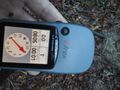
first proof
second proof
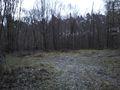
some impressions...
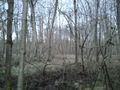
...from the...
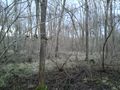
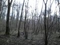
... the hashpoint (the boars ran 200m over there)
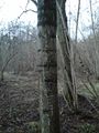
mark


Achievements
DODO earned the Land geohash achievement
|
DODO earned the OpenStreetMap achievement
|