Difference between revisions of "2015-01-30 52 1"
imported>Sourcerer m ([live] Arrived.) |
imported>Sourcerer (→Added New Expedition) |
||
| Line 1: | Line 1: | ||
| − | |||
| − | |||
| − | |||
| − | |||
| − | |||
| − | |||
| − | |||
| − | |||
| − | |||
| − | |||
{{meetup graticule | {{meetup graticule | ||
| lat=52 | | lat=52 | ||
| Line 15: | Line 5: | ||
}} | }} | ||
| − | |||
__NOTOC__ | __NOTOC__ | ||
| + | |||
== Location == | == Location == | ||
| − | + | ||
| + | In a field close to a public footpath north east of Wilby, Suffolk, UK. | ||
== Participants == | == Participants == | ||
| − | |||
| − | |||
| − | + | [[User:Sourcerer|Sourcerer]] | |
| − | |||
== Expedition == | == Expedition == | ||
| − | |||
| + | *Arrived. -- [[User:Sourcerer|Sourcerer]] ([[User talk:Sourcerer|talk]]) [http://www.openstreetmap.org/?lat=52.30548441&lon=1.28947735&zoom=16&layers=B000FTF @52.3055,1.2895] 11:05, 30 January 2015 (GMT) | ||
| + | |||
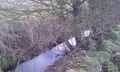
| + | This was 25km from home and easily reached on roads covered in a mixture of water, mud and ice. There was dry parking right by the start of the public footpath. The hashpoint was about 470 metres away. There were a couple of icy footbridges to add a bit of danger and excitement. Close to the hashpoint, the path was on the wrong side of a deep wet drainage ditch with a mature hedge of hawthorn, blackthorn and dog rose thorn - all impenetrable without a machete which I prefer not to carry! | ||
| + | |||
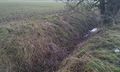
| + | About 130 metres further along the path there was a place to cross the ditch and there was a gap in the hedge. The ditch was nearly two metres deep and the only safe way down was a back side slide resulting in a muddy bum and nettle stings on the palms of my hands. The things we to for our sport! | ||
| − | + | An easy backtrack took me to the hashpoint for photos and message posting. Then the whole walk was done in reverse without further incident but quite a lot more mud. | |
| − | |||
| − | |||
== Photos == | == Photos == | ||
| − | + | ||
| − | |||
| − | |||
<gallery perrow="5"> | <gallery perrow="5"> | ||
| + | Image:2015-01-30 52 1 Sourcerer 1.jpg | Proof | ||
| + | Image:2015-01-30 52 1 Sourcerer 2.jpg | View from the Hashpoint | ||
| + | Image:2015-01-30 52 1 Sourcerer 3.jpg | View from the Hashpoint | ||
| + | Image:2015-01-30 52 1 Sourcerer 4.jpg | View from the Hashpoint | ||
| + | Image:2015-01-30 52 1 Sourcerer 5.jpg | Thorns and water barrier | ||
| + | Image:2015-01-30 52 1 Sourcerer 6.jpg | A Crossing Point | ||
</gallery> | </gallery> | ||
== Achievements == | == Achievements == | ||
{{#vardefine:ribbonwidth|800px}} | {{#vardefine:ribbonwidth|800px}} | ||
| − | |||
| + | I added the drainage ditches to Openstreetmap correcting and making the footpath crossing points clear. | ||
| − | + | {{OpenStreetMap achievement | |
| − | + | | latitude = 52 | |
| − | + | | longitude = 1 | |
| + | | date = 2015-01-30 | ||
| + | | OSMlink = 28505129 | ||
| + | | name = Sourcerer | ||
| + | }} | ||
| − | |||
| − | |||
| − | |||
| − | |||
| − | |||
| − | |||
| − | |||
| − | |||
[[Category:Expeditions]] | [[Category:Expeditions]] | ||
| − | |||
[[Category:Expeditions with photos]] | [[Category:Expeditions with photos]] | ||
| − | |||
| − | |||
| − | |||
| − | |||
| − | |||
[[Category:Coordinates reached]] | [[Category:Coordinates reached]] | ||
| − | |||
| − | |||
| − | |||
| − | |||
| − | |||
| − | |||
| − | |||
| − | |||
| − | |||
| − | |||
| − | |||
| − | |||
| − | |||
| − | |||
| − | |||
| − | |||
| − | |||
| − | |||
Revision as of 13:55, 30 January 2015
| Fri 30 Jan 2015 in 52,1: 52.3054971, 1.2894899 geohashing.info google osm bing/os kml crox |
Location
In a field close to a public footpath north east of Wilby, Suffolk, UK.
Participants
Expedition
- Arrived. -- Sourcerer (talk) @52.3055,1.2895 11:05, 30 January 2015 (GMT)
This was 25km from home and easily reached on roads covered in a mixture of water, mud and ice. There was dry parking right by the start of the public footpath. The hashpoint was about 470 metres away. There were a couple of icy footbridges to add a bit of danger and excitement. Close to the hashpoint, the path was on the wrong side of a deep wet drainage ditch with a mature hedge of hawthorn, blackthorn and dog rose thorn - all impenetrable without a machete which I prefer not to carry!
About 130 metres further along the path there was a place to cross the ditch and there was a gap in the hedge. The ditch was nearly two metres deep and the only safe way down was a back side slide resulting in a muddy bum and nettle stings on the palms of my hands. The things we to for our sport!
An easy backtrack took me to the hashpoint for photos and message posting. Then the whole walk was done in reverse without further incident but quite a lot more mud.
Photos
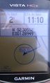
Proof
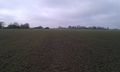
View from the Hashpoint
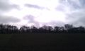
View from the Hashpoint
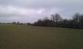
View from the Hashpoint
Thorns and water barrier
A Crossing Point


Achievements
I added the drainage ditches to Openstreetmap correcting and making the footpath crossing points clear.
Sourcerer earned the OpenStreetMap achievement
|