Difference between revisions of "2015-02-02 52 1"
imported>Sourcerer m ([live] Arrived.) |
imported>FippeBot m (Location) |
||
| (6 intermediate revisions by one other user not shown) | |||
| Line 1: | Line 1: | ||
| − | |||
| − | |||
| − | |||
| − | |||
| − | |||
| − | |||
| − | |||
| − | |||
| − | |||
| − | |||
{{meetup graticule | {{meetup graticule | ||
| lat=52 | | lat=52 | ||
| lon=1 | | lon=1 | ||
| date=2015-02-02 | | date=2015-02-02 | ||
| + | | graticule_name=Norwich, UK | ||
| + | | graticule_link=Norwich, United Kingdom | ||
}} | }} | ||
| − | |||
| − | |||
__NOTOC__ | __NOTOC__ | ||
== Location == | == Location == | ||
| − | + | ||
| + | In a meadow accessed through woodland at Benacre, Suffolk, UK. | ||
== Participants == | == Participants == | ||
| − | |||
| − | |||
| − | + | [[User:Sourcerer|Sourcerer]] | |
| − | |||
== Expedition == | == Expedition == | ||
| − | |||
| + | *Arrived. -- [[User:Sourcerer|Sourcerer]] ([[User talk:Sourcerer|talk]]) [http://www.openstreetmap.org/?lat=52.40337431&lon=1.70098722&zoom=16&layers=B000FTF @52.4034,1.7010] 00:07, 2 February 2015 (GMT) | ||
| − | + | The plan was to arrive on the dot of midnight but the snowy roads in north Norfolk caused an 11 minute delay. There was a place to park about 600 metres from the hashpoint. The access road was gated but the adjacent field was not fenced and there was farm vehicle access to the Church Covert woodland track via the field. | |
| − | + | ||
| − | + | This was geohashing at its ultimate. It was silent apart from the breeze. There was a moon, nearly full. The naked trees were casting skeletal shadows. I put up a few pigeons and later a pair of lapwings were calling, probably in alarm at my approach. Rabbits scattered as I drew near. | |
| + | |||
| + | The low lying meadows next to the Hundred River / Latymer Dam were beginning to freeze but there was quite a lot of water under the ice. The hashpoint was in the fourth meadow close to the river. A new wind turbine could be seen in the distance. No noises were coming from the Africa Alive Wild Life Park. | ||
| + | |||
| + | This hashpoint was quite close to home and the return trip was uneventful. | ||
== Photos == | == Photos == | ||
| − | + | ||
| − | |||
| − | |||
<gallery perrow="5"> | <gallery perrow="5"> | ||
| + | Image:2015-02-02_51_1_Sourcerer.jpg|Proof | ||
| + | Image:2015-02-01_52_1-Sourcerer-1.jpg|Track Log | ||
| + | Image:2015-02-02_52_1-Sourcerer-1.jpg|Track Log | ||
</gallery> | </gallery> | ||
== Achievements == | == Achievements == | ||
{{#vardefine:ribbonwidth|800px}} | {{#vardefine:ribbonwidth|800px}} | ||
| − | |||
| + | {{consecutive geohash 2 | ||
| + | | count = 6 | ||
| + | | latitude = 52 | ||
| + | | longitude = 1 | ||
| + | | date = 2015-01-28 | ||
| + | | name = Sourcerer | ||
| + | }} | ||
| + | {{Frozen Geohash | ||
| + | | latitude = 52 | ||
| + | | longitude = 1 | ||
| + | | date = 2015-02-02 | ||
| + | | temperature = -1 °C | ||
| + | | name = Sourcerer | ||
| + | }} | ||
| + | {{Midnight geohash | ||
| + | | latitude = 52 | ||
| + | | longitude = 1 | ||
| + | | date = 2015-02-02 | ||
| + | | name = Sourcerer | ||
| + | }} | ||
| − | + | {{Sourcerer_links | |
| − | + | | prev = 2015-02-01 52 1 | |
| − | + | | curr = 2015-02-02 52 1 | |
| + | | next = 2015-02-03 52 1 | ||
| + | | date = 2015-02-02 | ||
| + | }} | ||
| − | |||
| − | |||
| − | |||
| − | |||
| − | |||
| − | |||
| − | |||
| − | |||
[[Category:Expeditions]] | [[Category:Expeditions]] | ||
| − | |||
[[Category:Expeditions with photos]] | [[Category:Expeditions with photos]] | ||
| − | |||
| − | |||
| − | |||
| − | |||
| − | |||
[[Category:Coordinates reached]] | [[Category:Coordinates reached]] | ||
| − | + | {{location|GB|ENG|SFK}} | |
| − | |||
| − | |||
| − | |||
| − | |||
| − | |||
| − | |||
| − | |||
| − | |||
| − | |||
| − | |||
| − | |||
| − | |||
| − | |||
| − | |||
| − | |||
| − | |||
| − | |||
Latest revision as of 02:37, 15 August 2019
| Mon 2 Feb 2015 in Norwich, UK: 52.4033898, 1.7009610 geohashing.info google osm bing/os kml crox |
Location
In a meadow accessed through woodland at Benacre, Suffolk, UK.
Participants
Expedition
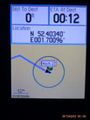
- Arrived. -- Sourcerer (talk) @52.4034,1.7010 00:07, 2 February 2015 (GMT)
The plan was to arrive on the dot of midnight but the snowy roads in north Norfolk caused an 11 minute delay. There was a place to park about 600 metres from the hashpoint. The access road was gated but the adjacent field was not fenced and there was farm vehicle access to the Church Covert woodland track via the field.
This was geohashing at its ultimate. It was silent apart from the breeze. There was a moon, nearly full. The naked trees were casting skeletal shadows. I put up a few pigeons and later a pair of lapwings were calling, probably in alarm at my approach. Rabbits scattered as I drew near.
The low lying meadows next to the Hundred River / Latymer Dam were beginning to freeze but there was quite a lot of water under the ice. The hashpoint was in the fourth meadow close to the river. A new wind turbine could be seen in the distance. No noises were coming from the Africa Alive Wild Life Park.
This hashpoint was quite close to home and the return trip was uneventful.
Photos
Proof
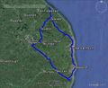
Track Log
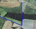
Track Log


Achievements
Sourcerer earned the Consecutive geohash achievement
|

Sourcerer earned the Midnight Geohash achievement
|
Expeditions and Plans
| 2015-02-02 | ||
|---|---|---|
| McMinnville, Oregon | Jim | Near a house in downtown Forest Grove |
| Mannheim, Germany | DODO | On the way from Heidelberg to the Königstuhl (kings chair), the local mount... |
| Norwich, United Kingdom | Sourcerer | In a meadow accessed through woodland at Benacre, Suffolk, UK. |
Sourcerer's Expedition Links
2015-02-01 52 1 - 2015-02-02 52 1 - 2015-02-03 52 1 - KML file download of Sourcerer's expeditions for use with Google Earth.