Difference between revisions of "2015-02-09 52 0"
From Geohashing
imported>Sourcerer m (→Photo) |
imported>Sourcerer m (→Photo) |
||
| Line 27: | Line 27: | ||
<gallery perrow="5"> | <gallery perrow="5"> | ||
Image:2015-02-09_52_0_Sourcerer_1423523622708.jpg | Proof | Image:2015-02-09_52_0_Sourcerer_1423523622708.jpg | Proof | ||
| − | Image:2015-02- | + | Image:2015-02-09_52_0_Sourcerer_Track.jpg | Track Log |
</gallery> | </gallery> | ||
Revision as of 03:17, 10 February 2015
| Mon 9 Feb 2015 in 52,0: 52.5151815, 0.8529513 geohashing.info google osm bing/os kml crox |
Location
Near Thetford Forest Park, Great Hocking, Norfolk, UK.
Participants
Expedition
- Arrived. -- Sourcerer (talk) @52.5119,.8446 23:16, 9 February 2015 (GMT)
The Norwich graticule hashpoint for 2015-02-10 52 1 looked reachable so it made sense to attempt this Cambridge point before midnight, aiming for the Norwich point soon after. Google Earth predicted a field full of pigs but, with crop rotation, the pig farming had moved elsewhere. Now it was a straightforward walk along a farm track, public right of way and a short field perimeter.
Foxes were barking and on the return walk, the moon rose in the east above the low clouds, giving a little light. Overhead there was crystal clear starlight. All the sane people were at home, asleep in bed.
Photos
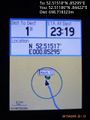
Proof
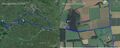
Track Log

Other geohashing expeditions on the same day
Expeditions and Plans
| 2015-02-09 | ||
|---|---|---|
| Cambridge, United Kingdom | Sourcerer | Near Thetford Forest Park, Great Hockham, Norfolk, UK. |
| Lycksele, Sweden | Nappe | Nära en tall vid Blå Vägen (E12:an). At a pine tree close to E12. |