Difference between revisions of "2015-02-09 52 0"
imported>Sourcerer m ([live picture] Proof) |
imported>FippeBot m (Location) |
||
| (7 intermediate revisions by one other user not shown) | |||
| Line 1: | Line 1: | ||
| − | |||
| − | |||
| − | |||
| − | |||
| − | |||
| − | |||
| − | |||
| − | |||
| − | |||
| − | |||
{{meetup graticule | {{meetup graticule | ||
| lat=52 | | lat=52 | ||
| lon=0 | | lon=0 | ||
| date=2015-02-09 | | date=2015-02-09 | ||
| + | | graticule_name=Cambridge, UK | ||
| + | | graticule_link=Cambridge, United Kingdom | ||
}} | }} | ||
| − | |||
| − | |||
__NOTOC__ | __NOTOC__ | ||
== Location == | == Location == | ||
| − | + | ||
| + | Near Thetford Forest Park, Great Hockham, Norfolk, UK. | ||
== Participants == | == Participants == | ||
| − | |||
| − | |||
| − | + | [[User:Sourcerer|Sourcerer]] | |
| − | |||
== Expedition == | == Expedition == | ||
| − | |||
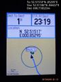
| − | == | + | *Arrived. -- [[User:Sourcerer|Sourcerer]] ([[User talk:Sourcerer|talk]]) [http://www.openstreetmap.org/?lat=52.51193610&lon=.84462620&zoom=16&layers=B000FTF @52.5119,.8446] 23:16, 9 February 2015 (GMT) |
| − | + | ||
| + | The Norwich graticule hashpoint for [[2015-02-10 52 1]] looked reachable so it made sense to attempt this Cambridge point before midnight, aiming for the Norwich point soon after. Google Earth predicted a field full of pigs but, with crop rotation, the pig farming had moved elsewhere. Now it was a straightforward walk along a farm track, public right of way and a short field perimeter. | ||
| + | |||
| + | Foxes were barking and on the return walk, the moon rose in the east above the low clouds, giving a little light. Overhead there was crystal clear starlight. All the sane people were at home, asleep in bed. | ||
== Photos == | == Photos == | ||
| − | + | ||
| − | |||
| − | |||
<gallery perrow="5"> | <gallery perrow="5"> | ||
| − | |||
Image:2015-02-09_52_0_Sourcerer_1423523622708.jpg | Proof | Image:2015-02-09_52_0_Sourcerer_1423523622708.jpg | Proof | ||
| + | Image:2015-02-09_52_0_Sourcerer_Track.jpg | Track Log | ||
</gallery> | </gallery> | ||
| − | == | + | {{Sourcerer_links |
| − | + | | prev = 2015-02-07 52 1 | |
| − | + | | curr = 2015-02-09 52 0 | |
| + | | next = 2015-02-10 52 1 | ||
| + | | date = 2015-02-09 | ||
| + | }} | ||
| − | |||
| − | |||
| − | |||
| − | |||
| − | |||
| − | |||
| − | |||
| − | |||
| − | |||
| − | |||
| − | |||
| − | |||
| − | |||
[[Category:Expeditions]] | [[Category:Expeditions]] | ||
| − | |||
[[Category:Expeditions with photos]] | [[Category:Expeditions with photos]] | ||
| − | |||
| − | |||
| − | |||
| − | |||
| − | |||
[[Category:Coordinates reached]] | [[Category:Coordinates reached]] | ||
| − | + | {{location|GB|ENG|NFK}} | |
| − | |||
| − | |||
| − | |||
| − | |||
| − | |||
| − | |||
| − | |||
| − | |||
| − | |||
| − | |||
| − | |||
| − | |||
| − | |||
| − | |||
| − | |||
| − | |||
| − | |||
Latest revision as of 02:40, 15 August 2019
| Mon 9 Feb 2015 in Cambridge, UK: 52.5151815, 0.8529513 geohashing.info google osm bing/os kml crox |
Location
Near Thetford Forest Park, Great Hockham, Norfolk, UK.
Participants
Expedition
- Arrived. -- Sourcerer (talk) @52.5119,.8446 23:16, 9 February 2015 (GMT)
The Norwich graticule hashpoint for 2015-02-10 52 1 looked reachable so it made sense to attempt this Cambridge point before midnight, aiming for the Norwich point soon after. Google Earth predicted a field full of pigs but, with crop rotation, the pig farming had moved elsewhere. Now it was a straightforward walk along a farm track, public right of way and a short field perimeter.
Foxes were barking and on the return walk, the moon rose in the east above the low clouds, giving a little light. Overhead there was crystal clear starlight. All the sane people were at home, asleep in bed.
Photos
Proof

Track Log

Expeditions and Plans
| 2015-02-09 | ||
|---|---|---|
| Cambridge, United Kingdom | Sourcerer | Near Thetford Forest Park, Great Hockham, Norfolk, UK. |
| Lycksele, Sweden | Nappe | Nära en tall vid Blå Vägen (E12:an). At a pine tree close to E12. |
Sourcerer's Expedition Links
2015-02-07 52 1 - 2015-02-09 52 0 - 2015-02-10 52 1 - KML file download of Sourcerer's expeditions for use with Google Earth.