Difference between revisions of "2015-02-11 47 -122"
imported>Thomcat ([live picture] Hashpoint 48 m ahead [http://www.openstreetmap.org/?lat=47.72381179&lon=-122.15010289&zoom=16&layers=B000FTF @47.7238,-122.1501]) |
imported>FippeBot m (Location) |
||
| (4 intermediate revisions by one other user not shown) | |||
| Line 18: | Line 18: | ||
== Expedition == | == Expedition == | ||
| − | + | Drove to the southern road, flyers in hand. Beyond the parking lot, leading to the small building, the road north was marked "No Trespassing", and the building was considerably larger than in the recent birds-eye photo. So I found a parking lot to utilize. | |
| − | + | A break in the fence led to the railroad tracks, which did *not* ban trespass. I found out later that they have been purchased by the county and will be turned into a trail of some sort soonish. Hooray! | |
| − | + | ||
| + | With low battery, I headed north until what felt like the approximate latitude. Lots of water running from the left side to the right side of my track, under various culverts. Where it wasn't running, it was stagnant and omnipresent. As I got close (missed my guess by roughly 20 meters), the left side was clearly some sort of swamp with occasional hillocks. | ||
| + | |||
| + | Sighting directly west, I spotted a largish tree that was maybe 30 or more meters away. It is likely the hashpoint is on dry land; it is unlikely that I can reach it from this side. Did I have time (and battery) to make another attempt on the tracks just west of the point? | ||
| + | |||
| + | The answer is no, though I did find the sign indicating future trails. Packing it in, I hope to revisit this when it *is* a trail and perhaps making an off-trail retro-venture. Some drier day, I hope. | ||
== Photos == | == Photos == | ||
| Line 30: | Line 35: | ||
Image:2015-02-11_47_-122_thomcat_1423697818558.jpg | Hashpoint 48 m ahead [http://www.openstreetmap.org/?lat=47.72381179&lon=-122.15010289&zoom=16&layers=B000FTF @47.7238,-122.1501] | Image:2015-02-11_47_-122_thomcat_1423697818558.jpg | Hashpoint 48 m ahead [http://www.openstreetmap.org/?lat=47.72381179&lon=-122.15010289&zoom=16&layers=B000FTF @47.7238,-122.1501] | ||
| − | |||
| − | == | + | Image:2015-02-11_47_-122_thomcat_1423697831073.jpg | South [http://www.openstreetmap.org/?lat=47.72381520&lon=-122.15009525&zoom=16&layers=B000FTF @47.7238,-122.1501] |
| − | |||
| − | |||
| + | Image:2015-02-11_47_-122_thomcat_1423697836690.jpg | North [http://www.openstreetmap.org/?lat=47.72381388&lon=-122.15010713&zoom=16&layers=B000FTF @47.7238,-122.1501] | ||
| − | [ | + | Image:2015-02-11_47_-122_thomcat_1423698808815.jpg | [http://www.openstreetmap.org/?lat=47.71657296&lon=-122.15369742&zoom=16&layers=B000FTF @47.7166,-122.1537] |
| + | </gallery> | ||
| − | |||
[[Category:Expeditions]] | [[Category:Expeditions]] | ||
| − | |||
[[Category:Expeditions with photos]] | [[Category:Expeditions with photos]] | ||
| − | |||
| − | |||
| − | |||
| − | |||
| − | |||
| − | |||
| − | |||
| − | |||
| − | |||
[[Category:Coordinates not reached]] | [[Category:Coordinates not reached]] | ||
| − | |||
| − | |||
[[Category:Not reached - Mother Nature]] | [[Category:Not reached - Mother Nature]] | ||
| − | + | {{location|US|WA|KN}} | |
| − | |||
| − | |||
| − | |||
| − | |||
| − | |||
| − | |||
| − | |||
| − | |||
| − | |||
| − | |||
Latest revision as of 02:41, 15 August 2019
| Wed 11 Feb 2015 in Seattle: 47.7237989, -122.1507513 geohashing.info google osm bing/os kml crox |
Location
A wooded hillside, south of Chateau Ste Michelle winery and west of the Sammamish river.
Participants
Plans
Visit sometime in the early afternoon, after work.
Expedition
Drove to the southern road, flyers in hand. Beyond the parking lot, leading to the small building, the road north was marked "No Trespassing", and the building was considerably larger than in the recent birds-eye photo. So I found a parking lot to utilize.
A break in the fence led to the railroad tracks, which did *not* ban trespass. I found out later that they have been purchased by the county and will be turned into a trail of some sort soonish. Hooray!
With low battery, I headed north until what felt like the approximate latitude. Lots of water running from the left side to the right side of my track, under various culverts. Where it wasn't running, it was stagnant and omnipresent. As I got close (missed my guess by roughly 20 meters), the left side was clearly some sort of swamp with occasional hillocks.
Sighting directly west, I spotted a largish tree that was maybe 30 or more meters away. It is likely the hashpoint is on dry land; it is unlikely that I can reach it from this side. Did I have time (and battery) to make another attempt on the tracks just west of the point?
The answer is no, though I did find the sign indicating future trails. Packing it in, I hope to revisit this when it *is* a trail and perhaps making an off-trail retro-venture. Some drier day, I hope.
Photos
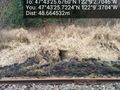
Hashpoint 48 m ahead @47.7238,-122.1501
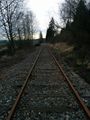
South @47.7238,-122.1501
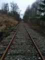
North @47.7238,-122.1501


