Difference between revisions of "2015-02-13 52 -0"
From Geohashing
imported>Sourcerer m ([live picture] Proof [http://www.openstreetmap.org/?lat=52.91769862&lon=-.30142128&zoom=16&layers=B000FTF @52.9177,-.3014]) |
imported>Sourcerer m (→Added New Expedition) |
||
| Line 1: | Line 1: | ||
| − | |||
| − | |||
| − | |||
| − | |||
| − | |||
| − | |||
| − | |||
| − | |||
| − | |||
| − | |||
{{meetup graticule | {{meetup graticule | ||
| lat=52 | | lat=52 | ||
| Line 15: | Line 5: | ||
}} | }} | ||
| − | |||
__NOTOC__ | __NOTOC__ | ||
| + | |||
== Location == | == Location == | ||
| − | + | ||
| + | In a field north of the A52 trunk road north east of Horbling, Lincolnshire, UK. | ||
== Participants == | == Participants == | ||
| − | |||
| − | |||
| − | + | [[User:Sourcerer|Sourcerer]] | |
| − | |||
== Expedition == | == Expedition == | ||
| − | |||
| + | *Arrived. -- [[User:Sourcerer|Sourcerer]] ([[User talk:Sourcerer|talk]]) [http://www.openstreetmap.org/?lat=52.91769862&lon=-.30142128&zoom=16&layers=B000FTF @52.9177,-.3014] 14:29, 13 February 2015 (GMT) | ||
| − | + | This was hash two of a triple [[2015-02-13 52 1]] :: [[2015-02-13 52 -0]] :: [[2015-02-13 52 -1]] | |
| − | + | ||
| − | + | This felt like Tron! Large areas of Lincolnshire are reclaimed marine salt marsh. While seeking the hashpoint, the drainage channels (deep and wet) kept getting in the way leading to backtracking, ditch crossing then following a new path at either 90 or 180 degrees to the original. In the end the correct maze combination was found and I arrived. The field perimeters were easy to follow. | |
== Photos == | == Photos == | ||
| − | + | ||
| − | |||
| − | |||
<gallery perrow="5"> | <gallery perrow="5"> | ||
| − | |||
Image:2015-02-13_52_-0_Sourcerer_1423837705551.jpg | Proof [http://www.openstreetmap.org/?lat=52.91769862&lon=-.30142128&zoom=16&layers=B000FTF @52.9177,-.3014] | Image:2015-02-13_52_-0_Sourcerer_1423837705551.jpg | Proof [http://www.openstreetmap.org/?lat=52.91769862&lon=-.30142128&zoom=16&layers=B000FTF @52.9177,-.3014] | ||
| + | Image:2015-02-13 52 -0 Sourcerer 2.jpg | View from the Hashpoint | ||
</gallery> | </gallery> | ||
| + | |||
| + | == Other geohashing expeditions on the same day == | ||
| + | |||
| + | {{expedition summaries|2015-02-13}} | ||
== Achievements == | == Achievements == | ||
{{#vardefine:ribbonwidth|800px}} | {{#vardefine:ribbonwidth|800px}} | ||
| − | |||
| + | {{consecutive geohash 2 | ||
| + | | count = 5 | ||
| + | | latitude = 52 | ||
| + | | longitude = 0 | ||
| + | | date = 2015-02-09 | ||
| + | | name = Sourcerer | ||
| + | }} | ||
| + | {{Multihash2 | ||
| + | | date = 2015-02-13 | ||
| + | | count = 2 | ||
| + | | name = Sourcerer | ||
| + | }} | ||
| − | |||
| − | |||
| − | |||
| − | |||
| − | |||
| − | |||
| − | |||
| − | |||
| − | |||
| − | |||
| − | |||
| − | |||
[[Category:Expeditions]] | [[Category:Expeditions]] | ||
| − | |||
[[Category:Expeditions with photos]] | [[Category:Expeditions with photos]] | ||
| − | |||
| − | |||
| − | |||
| − | |||
| − | |||
[[Category:Coordinates reached]] | [[Category:Coordinates reached]] | ||
| − | |||
| − | |||
| − | |||
| − | |||
| − | |||
| − | |||
| − | |||
| − | |||
| − | |||
| − | |||
| − | |||
| − | |||
| − | |||
| − | |||
| − | |||
| − | |||
| − | |||
| − | |||
Revision as of 18:39, 13 February 2015
| Fri 13 Feb 2015 in 52,-0: 52.9176924, -0.3014347 geohashing.info google osm bing/os kml crox |
Location
In a field north of the A52 trunk road north east of Horbling, Lincolnshire, UK.
Participants
Expedition
- Arrived. -- Sourcerer (talk) @52.9177,-.3014 14:29, 13 February 2015 (GMT)
This was hash two of a triple 2015-02-13 52 1 :: 2015-02-13 52 -0 :: 2015-02-13 52 -1
This felt like Tron! Large areas of Lincolnshire are reclaimed marine salt marsh. While seeking the hashpoint, the drainage channels (deep and wet) kept getting in the way leading to backtracking, ditch crossing then following a new path at either 90 or 180 degrees to the original. In the end the correct maze combination was found and I arrived. The field perimeters were easy to follow.
Photos
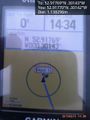
Proof @52.9177,-.3014
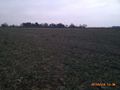
View from the Hashpoint


Other geohashing expeditions on the same day
Expeditions and Plans
| 2015-02-13 | ||
|---|---|---|
| Schweinfurt, Germany | GeorgDerReisende | The hash lies on a meadow in Wilhelmsthal near Eisenach. 53.5 meters away f... |
| Erfurt, Germany | crissar, Reinhard | The hash lies near Hengstbachhof located in Hetschburg. |
| Northampton, United Kingdom | Sourcerer | 2) In a field north of the A52 trunk road north east of Horbling, Lincolnsh... |
| Birmingham, United Kingdom | Sourcerer | 3) In a technology park where the M1 crosses the A52, between Nottingham an... |
| Norwich, United Kingdom | Sourcerer | 1) On the Cromer to Norwich railway line just east of Roughton Road station... |
Achievements
Sourcerer earned the Consecutive geohash achievement
|
Sourcerer earned the Multihash Achievement
|