Difference between revisions of "2015-02-18 52 0"
imported>Sourcerer m ([live picture] Proof. [http://www.openstreetmap.org/?lat=52.36447155&lon=.92082918&zoom=16&layers=B000FTF @52.3645,.9208]) |
imported>FippeBot m (Location) |
||
| (5 intermediate revisions by one other user not shown) | |||
| Line 1: | Line 1: | ||
| − | |||
| − | |||
| − | |||
| − | |||
| − | |||
| − | |||
| − | |||
| − | |||
| − | |||
| − | |||
{{meetup graticule | {{meetup graticule | ||
| lat=52 | | lat=52 | ||
| lon=0 | | lon=0 | ||
| date=2015-02-18 | | date=2015-02-18 | ||
| + | | graticule_name=Cambridge, UK | ||
| + | | graticule_link=Cambridge, United Kingdom | ||
}} | }} | ||
| − | |||
| − | |||
__NOTOC__ | __NOTOC__ | ||
== Location == | == Location == | ||
| − | + | In a ploughed field close to a public footpath behind St Mary's church, Market Weston, Suffolk, UK. | |
== Participants == | == Participants == | ||
| Line 31: | Line 21: | ||
== Expedition == | == Expedition == | ||
| + | *Arrived. -- [[User:Sourcerer|Sourcerer]] ([[User talk:Sourcerer|talk]]) [http://www.openstreetmap.org/?lat=52.36447155&lon=.92082918&zoom=16&layers=B000FTF @52.3645,.9208] 00:01, 18 February 2015 (GMT) | ||
| + | I parked in front of the church and walked through the cemetery just as midnight chimed on the church bells - four bings followed by twelve bongs. The hashpoint was a few paces into the freshly ploughed field. I got the evidence photo at exactly midnight. The church clock was about a minute fast. I wonder if ghosts use GPS or church clock time. Either way, I was not molested. | ||
| − | |||
| − | |||
| − | |||
| − | |||
== Photos == | == Photos == | ||
| Line 42: | Line 30: | ||
Image:2015-02-18_52_0_Sourcerer_1424217646140.jpg | Proof. [http://www.openstreetmap.org/?lat=52.36447155&lon=.92082918&zoom=16&layers=B000FTF @52.3645,.9208] | Image:2015-02-18_52_0_Sourcerer_1424217646140.jpg | Proof. [http://www.openstreetmap.org/?lat=52.36447155&lon=.92082918&zoom=16&layers=B000FTF @52.3645,.9208] | ||
| + | Image:2015-02-18_52_0_Sourcerer_2.jpg | Cemetery Pillar and Urn | ||
| + | Image:2015-02-18_52_0_Sourcerer_3.jpg | Church Sign | ||
| + | Image:2015-02-18_52_0_Sourcerer_4.jpg | Track Log | ||
</gallery> | </gallery> | ||
== Achievements == | == Achievements == | ||
{{#vardefine:ribbonwidth|800px}} | {{#vardefine:ribbonwidth|800px}} | ||
| + | {{gratuitous ribbon | ||
| + | | latitude = 52 | ||
| + | | longitude = 0 | ||
| + | | date = 2015-02-18 | ||
| + | | achievement = Haunted Hash Achievement | ||
| + | | description = walking through a cemetery as the bells tolled midnight. | ||
| + | | name = Sourcerer | ||
| + | | icon = 2015-02-18_52_0_Sourcerer_2.jpg | ||
| + | }} | ||
| − | == | + | {{Sourcerer_links |
| + | | prev = 2015-02-17 52 0 | ||
| + | | curr = 2015-02-18 52 0 | ||
| + | | next = 2015-02-19 52 1 | ||
| + | | date = 2015-02-18 | ||
| + | }} | ||
| − | |||
| − | |||
| − | |||
| − | |||
| − | |||
[[Category:Expeditions]] | [[Category:Expeditions]] | ||
| − | |||
[[Category:Expeditions with photos]] | [[Category:Expeditions with photos]] | ||
| − | |||
| − | |||
| − | |||
| − | |||
| − | |||
[[Category:Coordinates reached]] | [[Category:Coordinates reached]] | ||
| − | + | {{location|GB|ENG|SFK}} | |
| − | |||
| − | |||
| − | |||
| − | |||
| − | |||
| − | |||
| − | |||
| − | |||
| − | |||
| − | |||
| − | |||
| − | |||
| − | |||
| − | |||
| − | |||
| − | |||
| − | |||
Latest revision as of 02:46, 15 August 2019
| Wed 18 Feb 2015 in Cambridge, UK: 52.3644602, 0.9208611 geohashing.info google osm bing/os kml crox |
Location
In a ploughed field close to a public footpath behind St Mary's church, Market Weston, Suffolk, UK.
Participants
Plans
Drat - the Norwich points are in the sea. Have to do Cambridge then! This could be paired with 2015-02-17 52 0 spanning midnight.
Expedition
- Arrived. -- Sourcerer (talk) @52.3645,.9208 00:01, 18 February 2015 (GMT)
I parked in front of the church and walked through the cemetery just as midnight chimed on the church bells - four bings followed by twelve bongs. The hashpoint was a few paces into the freshly ploughed field. I got the evidence photo at exactly midnight. The church clock was about a minute fast. I wonder if ghosts use GPS or church clock time. Either way, I was not molested.
Photos
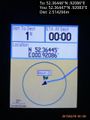
Proof. @52.3645,.9208
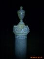
Cemetery Pillar and Urn

Church Sign

Track Log


Achievements
Sourcerer earned the Haunted Hash Achievement
|
Expeditions and Plans
| 2015-02-18 | ||
|---|---|---|
| Cambridge, United Kingdom | Sourcerer | In a ploughed field close to a public footpath behind St Mary's church, Mar... |
| Amsterdam, Netherlands | Palmpje, Tchakkazulu, TheOtherGuy | Amsterdam, Sarphatistraat at the back of Artis Zoo. Not sure if it's on the... |
| Hannover, Germany | Fippe | located near Ahlten on a field. |
Sourcerer's Expedition Links
2015-02-17 52 0 - 2015-02-18 52 0 - 2015-02-19 52 1 - KML file download of Sourcerer's expeditions for use with Google Earth.