Difference between revisions of "2015-02-21 48 11"
imported>TheOneRing (Created page with "{{meetup graticule | lat=48 | lon=11 | date=2015-02-21 }} == Location == The geohash is near that one of 2014-06-09 near Maisach. Perfect for Déjà Vu Geohash. == W...") |
imported>FippeBot m (Location) |
||
| (5 intermediate revisions by one other user not shown) | |||
| Line 6: | Line 6: | ||
== Location == | == Location == | ||
| − | The geohash is | + | The geohash is only 162m apart that one of [[2014-06-09]] near Maisach. Perfect for [[Déjà Vu Geohash]]. |
== Who Went == | == Who Went == | ||
[[User:TheOneRing|TheOneRing]] - by public transport. | [[User:TheOneRing|TheOneRing]] - by public transport. | ||
| − | == The | + | == The Expeditionn == |
| − | Anyone noticed, that this one is just a few meter away from that of [[2014-06-09]]? I | + | Anyone noticed, that this one is just a few meter away from that of [[2014-06-09]]? I thought that might be a good opportunity to get a [[Déjà Vu Geohash]] achievement. |
| + | |||
| + | I started right after coming back from the barber's and took a train to Maisach. The conditions at the beginning of the walk were the same like [[2014-06-09 | in June]]: approx. 1.5km as the bird flies. | ||
| + | |||
| + | I had to walk about 2.8km to the hash as I had to cross a field. Something was already seeded, but I could not recognise what exactly. Anyway I walked on tracks of tractors as far as possible. Furthermore, I stayed on the snow, because the field was very muddy. | ||
| + | |||
| + | At the geohash I took the usual photographs. But additionally, I walked back to the bridge I already crossed in June. Near the geohash, I had a short rest with a picnic and finally I walked back to Maisach and took trains home. | ||
| + | |||
| + | == Photos == | ||
| + | <gallery perrow="5"> | ||
| + | Image:20150221_48_11GPS.jpg|Coordinates reached | ||
| + | Image:20150221_48_11Info.jpg|Some more information | ||
| + | Image:20150221_48_11Geohash.jpg|Here I am | ||
| + | Image:20150221_48_11Me.jpg|The hasher, very happy | ||
| + | Image:20150221_48_11Picnic.jpg|A picnic on a bench, a rivulet in the background | ||
| + | Image:20140609_48_11Surrounding2.jpg|The bridge in June... | ||
| + | Image:20150221_48_11Surrounding1.jpg|...and the very bridge in February | ||
| + | Image:20150221_48_11Tracks.jpg|Tractor tracks | ||
| + | </gallery> | ||
| + | |||
| + | == Achievements == | ||
| + | {{land geohash | latitude = 48 | longitude = 11 | date = 2015-02-21 | name = TheOneRing}} | ||
| + | {{Public transport geohash | latitude = 48 | longitude = 11 | date = 2015-02-21 | name = TheOneRing}} | ||
| + | {{Déjà vu geohash | latitude = 48 | longitude = 11 | date = 2015-02-21 | olddate = 2014-06-09 | name = [[User:TheOneRing|TheOneRing]]}} | ||
| + | {{Picnic | latitude = 48 | longitude = 11 | date = 2015-02-21 | name = TheOneRing }} | ||
| + | |||
| + | Edit 2015-10-12: After defining the [[Two to the N achievement]], I award myself retroactively. | ||
| + | {{Two to the N achievement | count = 6 | latitude = 48 | longitude = 11 | date = 2015-02-21 | reached = true | name = TheOneRing }} | ||
| + | |||
| + | [[Category:Expeditions]] | ||
| + | [[Category:Expeditions with photos]] | ||
| + | [[Category:Coordinates reached]] | ||
| + | {{location|DE|BY|FFB}} | ||
Latest revision as of 02:48, 15 August 2019
| Sat 21 Feb 2015 in 48,11: 48.2219379, 11.2449723 geohashing.info google osm bing/os kml crox |
Location
The geohash is only 162m apart that one of 2014-06-09 near Maisach. Perfect for Déjà Vu Geohash.
Who Went
TheOneRing - by public transport.
The Expeditionn
Anyone noticed, that this one is just a few meter away from that of 2014-06-09? I thought that might be a good opportunity to get a Déjà Vu Geohash achievement.
I started right after coming back from the barber's and took a train to Maisach. The conditions at the beginning of the walk were the same like in June: approx. 1.5km as the bird flies.
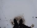
I had to walk about 2.8km to the hash as I had to cross a field. Something was already seeded, but I could not recognise what exactly. Anyway I walked on tracks of tractors as far as possible. Furthermore, I stayed on the snow, because the field was very muddy.
At the geohash I took the usual photographs. But additionally, I walked back to the bridge I already crossed in June. Near the geohash, I had a short rest with a picnic and finally I walked back to Maisach and took trains home.
Photos
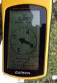
Coordinates reached
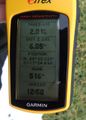
Some more information
Here I am
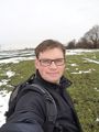
The hasher, very happy
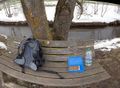
A picnic on a bench, a rivulet in the background
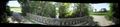
The bridge in June...
...and the very bridge in February
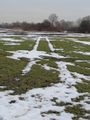
Tractor tracks


Achievements
TheOneRing earned the Land geohash achievement
|
TheOneRing earned the Public transport geohash achievement
|
TheOneRing earned the Déjà Vu Geohash Achievement
|
TheOneRing earned the Picnic achievement
|
Edit 2015-10-12: After defining the Two to the N achievement, I award myself retroactively.
