Difference between revisions of "2015-02-24 52 0"
From Geohashing
imported>Sourcerer m ([live picture] Proof. [http://www.openstreetmap.org/?lat=52.19207525&lon=.96604049&zoom=16&layers=B000FTF @52.1921,.9660]) |
imported>FippeBot m (Location) |
||
| (7 intermediate revisions by one other user not shown) | |||
| Line 3: | Line 3: | ||
| lon=0 | | lon=0 | ||
| date=2015-02-24 | | date=2015-02-24 | ||
| + | | graticule_name=Cambridge, UK | ||
| + | | graticule_link=Cambridge, United Kingdom | ||
}} | }} | ||
__NOTOC__ | __NOTOC__ | ||
| Line 15: | Line 17: | ||
== Expedition == | == Expedition == | ||
| − | Planning two hashpoints spanning midnight: [[2015-02-24 52 0]] :: [[2015-02-25 52 1]] | + | Planning two hashpoints and a retro-hash spanning midnight: [[2015-02-24 52 0]] :: [[2015-01-22 52 1 | Retro]] :: [[2015-02-25 52 1]] |
| + | *Arrived. -- [[User:Sourcerer|Sourcerer]] ([[User talk:Sourcerer|talk]]) [http://www.openstreetmap.org/?lat=52.19207525&lon=.96604049&zoom=16&layers=B000FTF @52.1921,.9660] 22:43, 24 February 2015 (GMT) | ||
| + | There was a new moon lighting this expedition. Unusually, there were people close to the hashpoint but they were blinded by their own car headlights so I don't think my little dance in the mud was noticed. | ||
| − | |||
== Photos == | == Photos == | ||
<gallery perrow="5"> | <gallery perrow="5"> | ||
| − | |||
Image:2015-02-24_52_0_Sourcerer_1424817791880.jpg | Proof. [http://www.openstreetmap.org/?lat=52.19207525&lon=.96604049&zoom=16&layers=B000FTF @52.1921,.9660] | Image:2015-02-24_52_0_Sourcerer_1424817791880.jpg | Proof. [http://www.openstreetmap.org/?lat=52.19207525&lon=.96604049&zoom=16&layers=B000FTF @52.1921,.9660] | ||
| + | Image:2015-02-24_52_0_Sourcerer_2.jpg | Track Log | ||
</gallery> | </gallery> | ||
| − | |||
| − | |||
== Achievements == | == Achievements == | ||
{{#vardefine:ribbonwidth|800px}} | {{#vardefine:ribbonwidth|800px}} | ||
| − | {{consecutive geohash | + | {{consecutive geohash 3 |
| − | | | + | | hashcount = 13 |
| + | | daycount = 10 | ||
| latitude = 52 | | latitude = 52 | ||
| longitude = 1 | | longitude = 1 | ||
| Line 39: | Line 41: | ||
| name = Sourcerer | | name = Sourcerer | ||
}} | }} | ||
| − | |||
| − | |||
| − | {{ | + | {{Sourcerer_links |
| − | + | | prev = 2015-02-23 52 1 | |
| − | + | | curr = 2015-02-24 52 0 | |
| + | | next = 2015-02-25 52 1 | ||
| + | | date = 2015-02-24 | ||
| + | }} | ||
| − | |||
[[Category:Expeditions]] | [[Category:Expeditions]] | ||
[[Category:Expeditions with photos]] | [[Category:Expeditions with photos]] | ||
[[Category:Coordinates reached]] | [[Category:Coordinates reached]] | ||
| − | + | {{location|GB|ENG|SFK}} | |
Latest revision as of 02:50, 15 August 2019
| Tue 24 Feb 2015 in Cambridge, UK: 52.1921225, 0.9660150 geohashing.info google osm bing/os kml crox |
Location
In a field close to and west of Stowmarket, Suffolk, UK.
Participants
Expedition
Planning two hashpoints and a retro-hash spanning midnight: 2015-02-24 52 0 :: Retro :: 2015-02-25 52 1
- Arrived. -- Sourcerer (talk) @52.1921,.9660 22:43, 24 February 2015 (GMT)
There was a new moon lighting this expedition. Unusually, there were people close to the hashpoint but they were blinded by their own car headlights so I don't think my little dance in the mud was noticed.
Photos
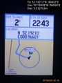
Proof. @52.1921,.9660
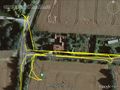
Track Log


Achievements
Sourcerer earned the Consecutive geohash achievement
|
Expeditions and Plans
| 2015-02-24 | ||
|---|---|---|
| Cambridge, United Kingdom | Sourcerer | In a field close to and west of Stowmarket, Suffolk, UK. |
| Utrecht, Netherlands | Tchakkazulu | located on Hofveld in Apeldoorn. |
| Helsinki, Finland | Sgt pepper, UndeadPriest | Between two apartment buildings in Vallila, Helsinki |
Sourcerer's Expedition Links
2015-02-23 52 1 - 2015-02-24 52 0 - 2015-02-25 52 1 - KML file download of Sourcerer's expeditions for use with Google Earth.