Difference between revisions of "2015-02-25 44 11"
imported>LucaPost m (→Photos) |
m (Location correction) |
||
| (15 intermediate revisions by 3 users not shown) | |||
| Line 1: | Line 1: | ||
| − | |||
| − | |||
| − | |||
| − | |||
| − | |||
| − | |||
| − | |||
| − | |||
| − | |||
| − | |||
{{meetup graticule | {{meetup graticule | ||
| lat=44 | | lat=44 | ||
| Line 28: | Line 18: | ||
== Plans == | == Plans == | ||
<!-- what were the original plans --> | <!-- what were the original plans --> | ||
| + | This looked like an easy expedition, being just a few kilometers out of Bologna urban area, along a road where I often go biking in the summer. | ||
| + | |||
| + | Hence the plan was for a quick before-work detour but, because of the rain and a road landslide, it turned into quite a challenge; I guess it counts as a significative first-ever geoHash -I still have to browse for proper geohash categories and achievements... | ||
== Expedition == | == Expedition == | ||
<!-- how it all turned out. your narrative goes here. --> | <!-- how it all turned out. your narrative goes here. --> | ||
| − | + | After driving to the road landslide I parked and decided to try by foot, all in all it turned out to be a one-hour walk on steep, MUDDY hills, under light rain; luckily I have extra shoes, socks and pants in the car trunk! | |
| − | |||
| − | |||
== Photos == | == Photos == | ||
| Line 41: | Line 32: | ||
<gallery perrow="15"> | <gallery perrow="15"> | ||
Image:2015-02-25 44 11 1.JPG | ooppps road landslide, let's walk | Image:2015-02-25 44 11 1.JPG | ooppps road landslide, let's walk | ||
| − | Image_2015-02-25-44-11_2.jpg | WAit me there, Car | + | Image:Image_2015-02-25-44-11_2.jpg | WAit me there, Car |
| − | Image: | + | Image:Image_2015-02-25-44-11_3.jpg | geohash is behind that hill |
| − | Image: | + | Image:Image_2015-02-25-44-11_4.jpg | more walking, it looks flat in these pics |
| − | Image: | + | Image:Image_2015-02-25-44-11_5.jpg | boots still somewhat clean |
| − | Image: | + | Image:Image_2015-02-25-44-11_6.jpg | not there yet, behind this other hill |
| − | Image: | + | Image:Image_2015-02-25-44-11_7.jpg | not much traffic this morning out here |
| − | Image: | + | Image:Image_2015-02-25-44-11_8.jpg | finally, geohash is in view now |
| − | Image: | + | Image:Image_2015-02-25-44-11_9.jpg | almost there |
| − | Image: | + | Image:Image_2015-02-25-44-11_10.jpg | good enough ??!? |
| − | Image: | + | Image:Image_2015-02-25-44-11_11.jpg | me, on the spot |
| − | Image: | + | Image:Image_2015-02-25-44-11_12.jpg | a 360-degree (almost) pano from the geohash |
| − | Image: | + | Image:Image_2015-02-25-44-11_13.jpg | on the way back, this time steepness preserved ! |
| − | Image: | + | Image:Image_2015-02-25-44-11_14.jpg | earthworms party! ..only life-form I met |
| − | Image: | + | Image:Image_2015-02-25-44-11_15.jpg | aka 'mountain creek road', so glad I left the car early ! |
| − | |||
</gallery> | </gallery> | ||
| Line 63: | Line 53: | ||
| − | |||
| − | |||
| − | |||
| − | |||
| − | |||
| − | |||
| − | |||
| − | |||
| − | |||
| − | |||
| − | |||
| − | |||
[[Category:Expeditions]] | [[Category:Expeditions]] | ||
| − | |||
[[Category:Expeditions with photos]] | [[Category:Expeditions with photos]] | ||
| − | |||
| − | |||
| − | |||
| − | |||
| − | |||
[[Category:Coordinates reached]] | [[Category:Coordinates reached]] | ||
| − | + | {{location|IT|ER}} | |
| − | |||
| − | |||
| − | |||
| − | |||
| − | |||
| − | |||
| − | |||
| − | |||
| − | |||
| − | |||
| − | |||
| − | |||
| − | |||
| − | |||
| − | |||
| − | |||
| − | |||
Latest revision as of 15:12, 28 July 2021
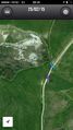
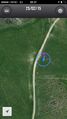
| Wed 25 Feb 2015 in 44,11: 44.3887025, 11.4125312 geohashing.info google osm bing/os kml crox |
Location
Right on the ridge between Zena valley and Idice valley
Participants
Plans
This looked like an easy expedition, being just a few kilometers out of Bologna urban area, along a road where I often go biking in the summer.
Hence the plan was for a quick before-work detour but, because of the rain and a road landslide, it turned into quite a challenge; I guess it counts as a significative first-ever geoHash -I still have to browse for proper geohash categories and achievements...
Expedition
After driving to the road landslide I parked and decided to try by foot, all in all it turned out to be a one-hour walk on steep, MUDDY hills, under light rain; luckily I have extra shoes, socks and pants in the car trunk!
Photos
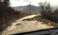
ooppps road landslide, let's walk
WAit me there, Car
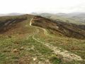
geohash is behind that hill
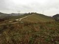
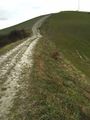
more walking, it looks flat in these pics
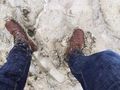
boots still somewhat clean
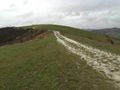
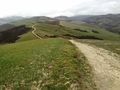
not there yet, behind this other hill
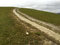
not much traffic this morning out here
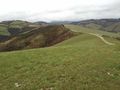
finally, geohash is in view now
almost there
good enough ??!?
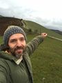
me, on the spot
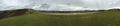
a 360-degree (almost) pano from the geohash
on the way back, this time steepness preserved !
earthworms party! ..only life-form I met
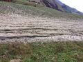
aka 'mountain creek road', so glad I left the car early !


