Difference between revisions of "2015-02-25 49 8"
From Geohashing
imported>DODO (→Expedition) |
imported>FippeBot m (Location) |
||
| (3 intermediate revisions by one other user not shown) | |||
| Line 41: | Line 41: | ||
== Tracklog == | == Tracklog == | ||
<!-- if your GPS device keeps a log, you may post a link here --> | <!-- if your GPS device keeps a log, you may post a link here --> | ||
| + | [https://www.komoot.de/tour/4291068 Bull 44 KM] | ||
== Photos == | == Photos == | ||
| Line 46: | Line 47: | ||
Image:2012-##-## ## ## Alpha.jpg | Witty Comment | Image:2012-##-## ## ## Alpha.jpg | Witty Comment | ||
--> | --> | ||
| − | <gallery perrow=" | + | <gallery perrow="6"> |
| + | Image:2015-02-25_49_8-1.jpg|staked bull | ||
| + | Image:2015-02-25_49_8-2.jpg|I feel like I have seen this field before | ||
| + | Image:2015-02-25_49_8-4.jpg|proof | ||
| + | Image:2015-02-25_49_8-5.jpg|view from 2015-02-22_49_8 to 2015-01-22_49_8 | ||
| + | Image:2015-02-25_49_8-6.jpg|grin (or something like that) | ||
| + | Image:2015-02-25_49_8-7.jpg|and the ferry again | ||
</gallery> | </gallery> | ||
== Achievements == | == Achievements == | ||
{{#vardefine:ribbonwidth|800px}} | {{#vardefine:ribbonwidth|800px}} | ||
| − | + | {{land geohash | |
| + | | latitude = 49 | ||
| + | | longitude = 8 | ||
| + | | date = 2015-02-25 | ||
| + | | name = DODO | ||
| + | }} | ||
| + | {{Template:Tron | ||
| + | | latitude = 49 | ||
| + | | longitude = 8 | ||
| + | | date = 2015-02-25 | ||
| + | | name = DODO | ||
| + | | possessive = his | ||
| + | | tracklog = https://www.komoot.de/tour/4291068 | ||
| + | }} | ||
| − | + | {{Déjà vu geohash | |
| − | + | | latitude = 49 | |
| − | [[ | + | | longitude = 8 |
| + | | date = 2015-02-25 | ||
| + | | olddate = [[2015-01-22_49_8|2015-01-22]] | ||
| + | | name = DODO | ||
| + | }} | ||
| − | |||
| − | + | [[Category:Coordinates reached]] | |
| − | + | [[Category:Expeditions with photos]] | |
| − | [[Category: | ||
| − | |||
| − | |||
| − | |||
[[Category:Expeditions]] | [[Category:Expeditions]] | ||
| − | + | {{location|DE|RP|RP}} | |
| − | |||
| − | |||
| − | |||
| − | |||
| − | |||
| − | |||
| − | |||
| − | |||
| − | |||
| − | |||
| − | |||
| − | |||
| − | |||
| − | |||
| − | |||
| − | |||
| − | |||
| − | |||
| − | |||
| − | |||
| − | |||
| − | |||
| − | |||
| − | |||
| − | |||
Latest revision as of 02:51, 15 August 2019
| Wed 25 Feb 2015 in 49,8: 49.3887025, 8.4125312 geohashing.info google osm bing/os kml crox |
Location
On the edge of the same field between Schifferstadt and Waldsee as the 2015-01-22-Geohash was.
Participants
Plans
Go there by bull on my way to the office. Using the same way as 5 weeks ago and gaining a deja-vu.
Expedition
Things that were different than on 2015-01-22_49_8:
- The sun was already set and so I didn't have to ride in the dark and the pictures I took are not all just black.
- The field looked still freshly ploughed, but the ground was much harder this time.
- I only had to walk 20 m into the field instead of 120 m.
- I left the hash with both gloves.
- I took the right way and didn't have to push the bull.
Tracklog
Photos
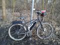
staked bull
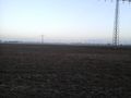
I feel like I have seen this field before
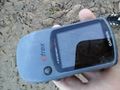
proof
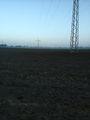
view from 2015-02-22_49_8 to 2015-01-22_49_8
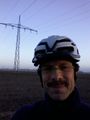
grin (or something like that)
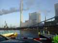
and the ferry again


Achievements
DODO earned the Land geohash achievement
|
DODO earned the Tron achievement
|
DODO earned the Déjà Vu Geohash Achievement
|