Difference between revisions of "2015-02-28 52 1"
imported>Sourcerer m (→Plan) |
m |
||
| (9 intermediate revisions by 3 users not shown) | |||
| Line 3: | Line 3: | ||
| lon=1 | | lon=1 | ||
| date=2015-02-28 | | date=2015-02-28 | ||
| + | | graticule_name=Norwich, UK | ||
| + | | graticule_link=Norwich, United Kingdom | ||
}} | }} | ||
__NOTOC__ | __NOTOC__ | ||
== Location == | == Location == | ||
| − | + | 1.9 km out at sea near Hopton (Norfolk) and Corton (Suffolk), UK. | |
== Participants == | == Participants == | ||
| Line 29: | Line 31: | ||
Perhaps I can do a message in a bottle Macgyver Achievement. I have checked the Met Office charts for wind direction to estimate where to launch the bottle for it to sail to the hashpoint. I have checked for [http://www.yachtpilot.net/lowestoft.html tidal flows]. If I launch before noon, there should be little tidal flow and the wind should take the bottle to the point. | Perhaps I can do a message in a bottle Macgyver Achievement. I have checked the Met Office charts for wind direction to estimate where to launch the bottle for it to sail to the hashpoint. I have checked for [http://www.yachtpilot.net/lowestoft.html tidal flows]. If I launch before noon, there should be little tidal flow and the wind should take the bottle to the point. | ||
| − | Here is the message. | + | Here is the message and its bottle. |
[[File:2015-02-28 52 1 Sourcerer 3.jpg]] and [[File:2015-02-28 52 1 Sourcerer 4.jpg]] | [[File:2015-02-28 52 1 Sourcerer 3.jpg]] and [[File:2015-02-28 52 1 Sourcerer 4.jpg]] | ||
| − | == Expedition == | + | == Expedition - Fail == |
| − | The point was | + | The point was 1.9 km out at sea. Am I doomed never to reach these points? Will I ever complete my minesweeper with [[North_Sea_53,_1]]? |
* [http://www.leisuremarinetraining.co.uk/LMT-course-info1.html RYA Day Skipper] - Get the qualification! | * [http://www.leisuremarinetraining.co.uk/LMT-course-info1.html RYA Day Skipper] - Get the qualification! | ||
* [http://www.boatsharefinder.org/search.aspx?region=East&type=All&minprice=0&maxprice=9999 Boat Share] - Buy a boat share. | * [http://www.boatsharefinder.org/search.aspx?region=East&type=All&minprice=0&maxprice=9999 Boat Share] - Buy a boat share. | ||
* [http://www.charterboats-uk.co.uk/port/lowestoft/ Lowestoft Boat Charter] - Or perhaps charter a boat with a trained skipper. | * [http://www.charterboats-uk.co.uk/port/lowestoft/ Lowestoft Boat Charter] - Or perhaps charter a boat with a trained skipper. | ||
| + | |||
| + | *Launched Macgyver bottle - Failed - Retrieved bottle. Now seeking a better launch point. -- [[User:Sourcerer|Sourcerer]] ([[User talk:Sourcerer|talk]]) [http://www.openstreetmap.org/?lat=52.53394425&lon=1.73923552&zoom=16&layers=B000FTF @52.5339,1.7392] 11:55, 28 February 2015 (GMT) | ||
| + | |||
| + | *Macgyver bottle re-launch - Success - Bottle heading south and out to sea. -- [[User:Sourcerer|Sourcerer]] ([[User talk:Sourcerer|talk]]) [http://www.openstreetmap.org/?lat=52.57202089&lon=1.73855424&zoom=16&layers=B000FTF @52.5720,1.7386] 12:24, 28 February 2015 (GMT) | ||
| + | |||
| + | The cliffs at the first launch point were creating a wind vortex which caused the launched Macgyver bottle to sail ashore almost immediately. Plan B was to head north and make use of the tide now flowing south after the time delay. Away from the cliffs, the wind would push the bottle out to sea. This worked perfectly. Of course the fatal flaw was the lack of any ability to track the launched bottle. The technology exists and has been used to track whales, dolphins and birds but never Macgyver bottles. | ||
== Photos == | == Photos == | ||
<gallery perrow="5"> | <gallery perrow="5"> | ||
| − | + | Image:2015-02-28 52 1 Sourcerer 05.jpg | Track logs and launch points | |
| + | Image:2015-02-28 52 1 Sourcerer 06.jpg | Beach access | ||
| + | Image:2015-02-28 52 1 Sourcerer 07.jpg | Ignore this sign | ||
| + | Image:2015-02-28 52 1 Sourcerer 08.jpg | This is more of a problem | ||
| + | Image:2015-02-28 52 1 Sourcerer 09.jpg | Closest approach 1.9km | ||
| + | Image:2015-02-28 52 1 Sourcerer 10.jpg | Gorleston Harbour Wall - New launch point | ||
| + | Image:2015-02-28 52 1 Sourcerer 11.jpg | Waves in the harbour entrance | ||
| + | Image:2015-02-28 52 1 Sourcerer 12.jpg | The Macgyver Bottle | ||
| + | Image:2015-02-28 52 1 Sourcerer 13.jpg | The Macgyver Bottle on its journey | ||
</gallery> | </gallery> | ||
| Line 50: | Line 66: | ||
{{#vardefine:ribbonwidth|700px}} | {{#vardefine:ribbonwidth|700px}} | ||
| + | {{gratuitous ribbon | ||
| + | | latitude = 52 | ||
| + | | longitude = 1 | ||
| + | | date = 2015-02-28 | ||
| + | | achievement = MacGyver Achievement Honourable Mention | ||
| + | | description = launching a message in a bottle taking account of both wind and tide in the hope that it would reach the hashpoint at | ||
| + | | name = Sourcerer | ||
| + | }} | ||
| + | '''Watch this space in case someone finds the message-in-the-bottle and posts here. How cool would that be?''' | ||
| − | == | + | {{Sourcerer_links |
| + | | prev = 2015-02-27 52 1 | ||
| + | | curr = 2015-02-28 52 1 | ||
| + | | next = 2015-03-05 52 1 | ||
| + | | date = 2015-02-28 | ||
| + | }} | ||
| − | |||
| − | |||
| − | |||
[[Category:Expeditions]] | [[Category:Expeditions]] | ||
[[Category:Expeditions with photos]] | [[Category:Expeditions with photos]] | ||
[[Category:Coordinates not reached]] | [[Category:Coordinates not reached]] | ||
| − | - | + | [[Category:Not reached - Mother Nature]] |
| + | {{location|GB|ENG}} | ||
Latest revision as of 10:16, 28 March 2022
| Sat 28 Feb 2015 in Norwich, UK: 52.5330389, 1.7681674 geohashing.info google osm bing/os kml crox |
Location
1.9 km out at sea near Hopton (Norfolk) and Corton (Suffolk), UK.
Participants
Plans
Go to the beach, as close as possible and then cry! Return home and search for Boat Shares and Day Skipper certification. These marine hashpoints are getting me down.
There are cliffs which are eroding rapidly. The beach can be unsafe at high tide.

You don't want to be too close if there is a land slide.

BBC Report - House Falls Into The Sea
Perhaps I can do a message in a bottle Macgyver Achievement. I have checked the Met Office charts for wind direction to estimate where to launch the bottle for it to sail to the hashpoint. I have checked for tidal flows. If I launch before noon, there should be little tidal flow and the wind should take the bottle to the point.
Here is the message and its bottle.
 and
and 
Expedition - Fail
The point was 1.9 km out at sea. Am I doomed never to reach these points? Will I ever complete my minesweeper with North_Sea_53,_1?
- RYA Day Skipper - Get the qualification!
- Boat Share - Buy a boat share.
- Lowestoft Boat Charter - Or perhaps charter a boat with a trained skipper.
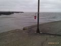
- Launched Macgyver bottle - Failed - Retrieved bottle. Now seeking a better launch point. -- Sourcerer (talk) @52.5339,1.7392 11:55, 28 February 2015 (GMT)
- Macgyver bottle re-launch - Success - Bottle heading south and out to sea. -- Sourcerer (talk) @52.5720,1.7386 12:24, 28 February 2015 (GMT)
The cliffs at the first launch point were creating a wind vortex which caused the launched Macgyver bottle to sail ashore almost immediately. Plan B was to head north and make use of the tide now flowing south after the time delay. Away from the cliffs, the wind would push the bottle out to sea. This worked perfectly. Of course the fatal flaw was the lack of any ability to track the launched bottle. The technology exists and has been used to track whales, dolphins and birds but never Macgyver bottles.
Photos
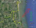
Track logs and launch points
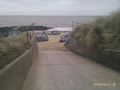
Beach access
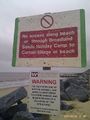
Ignore this sign
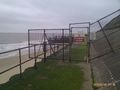
This is more of a problem
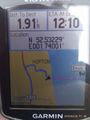
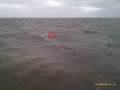
Closest approach 1.9km
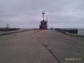
Gorleston Harbour Wall - New launch point
Waves in the harbour entrance
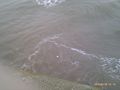
The Macgyver Bottle
The Macgyver Bottle on its journey


Achievements
Sourcerer earned the MacGyver Achievement Honourable Mention
|
Watch this space in case someone finds the message-in-the-bottle and posts here. How cool would that be?
Expeditions and Plans
| 2015-02-28 | ||
|---|---|---|
| Des Moines, Iowa | Trenchcoat | Somewhere |
| Portland, Oregon | Jim | North of Beaverton, near Barnes Road |
| Frankfurt am Main, Germany | GeorgDerReisende | The hash lies on the cycle path along the state road from Garbenteich to Li... |
| Rotterdam, Netherlands | FelixTheCat | In Mastenbos forest, just south of Breda. |
| Norwich, United Kingdom | Sourcerer | 1.9 km out at sea near Hopton (Norfolk) and Corton (Suffolk), UK. |
Sourcerer's Expedition Links
2015-02-27 52 1 - 2015-02-28 52 1 - 2015-03-05 52 1 - KML file download of Sourcerer's expeditions for use with Google Earth.