Difference between revisions of "2015-03-05 52 1"
From Geohashing
imported>Sourcerer m ([live picture] [http://www.openstreetmap.org/?lat=52.42776096&lon=1.35201573&zoom=16&layers=B000FTF @52.4278,1.3520]) |
imported>Sourcerer m (→New Expedition) |
||
| Line 19: | Line 19: | ||
== Expedition == | == Expedition == | ||
| + | *Arrived. -- [[User:Sourcerer|Sourcerer]] ([[User talk:Sourcerer|talk]]) [http://www.openstreetmap.org/?lat=52.42776096&lon=1.35201573&zoom=16&layers=B000FTF @52.4278,1.3520] 16:06, 5 March 2015 (GMT) | ||
| + | Easy - I forgot my Garmin GPSr and my phone battery had four red bars but it lasted long enough to take and post a landmark photo and post the "Arrived" message. | ||
| + | There seems to be a problem with the expedition template. The map shows the N51 highway which is not a UK road number; Ireland possibly. | ||
| − | |||
== Photos == | == Photos == | ||
<gallery perrow="5"> | <gallery perrow="5"> | ||
| − | + | Image:2015-03-05_52_1_Sourcerer_1425571606582.jpg | [http://www.openstreetmap.org/?lat=52.42776096&lon=1.35201573&zoom=16&layers=B000FTF @52.4278,1.3520] Proof. | |
| − | Image:2015-03-05_52_1_Sourcerer_1425571606582.jpg | [http://www.openstreetmap.org/?lat=52.42776096&lon=1.35201573&zoom=16&layers=B000FTF @52.4278,1.3520] | ||
</gallery> | </gallery> | ||
| − | |||
| − | |||
| − | |||
== Other geohashing expeditions on the same day == | == Other geohashing expeditions on the same day == | ||
| Line 37: | Line 35: | ||
{{expedition summaries|2015-03-05}} | {{expedition summaries|2015-03-05}} | ||
| − | |||
| − | |||
[[Category:Expeditions]] | [[Category:Expeditions]] | ||
[[Category:Expeditions with photos]] | [[Category:Expeditions with photos]] | ||
[[Category:Coordinates reached]] | [[Category:Coordinates reached]] | ||
| − | |||
Revision as of 18:10, 5 March 2015
| Thu 5 Mar 2015 in 52,1: 52.4277491, 1.3520480 geohashing.info google osm bing/os kml crox |
Location
In a field very close to a public footpath north of Homersfield, Norfolk, UK.
Participants
Plans
Sourcerer is not geohashing this month due to a house move but this is so close to home and easily reached that it is irresistible.
Expedition
- Arrived. -- Sourcerer (talk) @52.4278,1.3520 16:06, 5 March 2015 (GMT)
Easy - I forgot my Garmin GPSr and my phone battery had four red bars but it lasted long enough to take and post a landmark photo and post the "Arrived" message.
There seems to be a problem with the expedition template. The map shows the N51 highway which is not a UK road number; Ireland possibly.
Photos
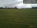
@52.4278,1.3520 Proof.

Other geohashing expeditions on the same day
Expeditions and Plans
| 2015-03-05 | ||
|---|---|---|
| Buffalo, New York | Pedalpusher | Next to what looks like the Allegany Hills golf course Clubhouse |
| Milano, Italy | Thomcat | On crop land just south of Vigliano, which is just east of Milano. |
| Zürich, Switzerland | Calamus | Near a garden in Killwangen. |
| Kassel, Germany | GeorgDerReisende | lat.427749, lon.352048: The hash lay on the hill Wartberg between Calde... |
| Norwich, United Kingdom | Sourcerer | In a field very close to a public footpath north of Homersfield, Norfolk, U... |