Difference between revisions of "2015-03-07 52 1"
From Geohashing
imported>Sourcerer m ([live] Arrived.) |
imported>FippeBot m (Location) |
||
| (5 intermediate revisions by one other user not shown) | |||
| Line 1: | Line 1: | ||
| − | |||
| − | |||
| − | |||
| − | |||
| − | |||
| − | |||
| − | |||
| − | |||
| − | |||
| − | |||
{{meetup graticule | {{meetup graticule | ||
| lat=52 | | lat=52 | ||
| lon=1 | | lon=1 | ||
| date=2015-03-07 | | date=2015-03-07 | ||
| + | | graticule_name=Norwich, UK | ||
| + | | graticule_link=Norwich, United Kingdom | ||
}} | }} | ||
| − | |||
| − | |||
__NOTOC__ | __NOTOC__ | ||
== Location == | == Location == | ||
| − | + | ||
| + | 10 metres from the road at Wingfield, Suffolk, UK. | ||
== Participants == | == Participants == | ||
| − | |||
| − | |||
| − | + | [[User:Sourcerer|Sourcerer]] | |
| − | |||
== Expedition == | == Expedition == | ||
| − | |||
| + | *Arrived. -- [[User:Sourcerer|Sourcerer]] ([[User talk:Sourcerer|talk]]) [http://www.openstreetmap.org/?lat=52.34955847&lon=1.27505779&zoom=16&layers=B000FTF @52.3496,1.2751] 15:14, 7 March 2015 (GMT) | ||
| + | |||
| + | [[User:Sourcerer|Sourcerer]] is not geohashing this month due to a house move. Today the weather was warm and sunny for the first time this year. Spring has arrived (until it goes again). So the choice: stay indoors painting and decorating or get outdoors and visit this easiest of hashpoints. What would you do? | ||
| − | + | Today I was confronted by the "public". Fortunately I had the perfect cover story. I had just photographed an attractive primrose in the roadside ditch and this explained my mini-trespass. Wild flower photography is easier to explain than geohashing. | |
| − | |||
| − | |||
== Photos == | == Photos == | ||
| − | |||
| − | |||
| − | |||
<gallery perrow="5"> | <gallery perrow="5"> | ||
| + | Image:2015-03-07_52_1_Sourcerer_1425741229000.jpg | [http://www.openstreetmap.org/?lat=52.34955311&lon=1.27505243&zoom=16&layers=B000FTF @52.3496,1.2751] | ||
| + | Image:2015-03-07 52 1 Sourcerer 1.jpg | Primrose and Bee | ||
</gallery> | </gallery> | ||
| − | == | + | {{Sourcerer_links |
| − | + | | prev = 2015-03-05 52 1 | |
| − | + | | curr = 2015-03-07 52 1 | |
| + | | next = 2015-03-13 52 1 | ||
| + | | date = 2015-03-07 | ||
| + | }} | ||
| − | |||
| − | |||
| − | |||
| − | |||
| − | |||
| − | |||
| − | |||
| − | |||
| − | |||
| − | |||
| − | |||
| − | |||
| − | |||
[[Category:Expeditions]] | [[Category:Expeditions]] | ||
| − | |||
[[Category:Expeditions with photos]] | [[Category:Expeditions with photos]] | ||
| − | |||
| − | |||
| − | |||
| − | |||
| − | |||
[[Category:Coordinates reached]] | [[Category:Coordinates reached]] | ||
| − | + | {{location|GB|ENG|SFK}} | |
| − | |||
| − | |||
| − | |||
| − | |||
| − | |||
| − | |||
| − | |||
| − | |||
| − | |||
| − | |||
| − | |||
| − | |||
| − | |||
| − | |||
| − | |||
| − | |||
| − | |||
Latest revision as of 02:57, 15 August 2019
| Sat 7 Mar 2015 in Norwich, UK: 52.3495836, 1.2750481 geohashing.info google osm bing/os kml crox |
Location
10 metres from the road at Wingfield, Suffolk, UK.
Participants
Expedition
- Arrived. -- Sourcerer (talk) @52.3496,1.2751 15:14, 7 March 2015 (GMT)
Sourcerer is not geohashing this month due to a house move. Today the weather was warm and sunny for the first time this year. Spring has arrived (until it goes again). So the choice: stay indoors painting and decorating or get outdoors and visit this easiest of hashpoints. What would you do?
Today I was confronted by the "public". Fortunately I had the perfect cover story. I had just photographed an attractive primrose in the roadside ditch and this explained my mini-trespass. Wild flower photography is easier to explain than geohashing.
Photos
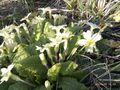
Primrose and Bee


Expeditions and Plans
| 2015-03-07 | ||
|---|---|---|
| Córdoba, Argentina | Onicofago, Kid | On the side of a suburban street, near a trash bin, not far from an importa... |
| Firenze, Italy | LucaPost | Residential area on the Cassia road, connecting Siena to Florence. |
| Zürich, Switzerland | Calamus | A parking lot in Wohlen AG. |
| Kassel, Germany | GeorgDerReisende | 51.34958N 9.27504E: the hash lies on the Großer Bärenberg west of Zierenber... |
| Norwich, United Kingdom | Sourcerer | 10 metres from the road at Wingfield, Suffolk, UK. |
| Utrecht, Netherlands | Eupeodes, Thomcat, Folks from all the xkcd, * CO2, * Martin, * | Explore the historical center of Utrecht |
Sourcerer's Expedition Links
2015-03-05 52 1 - 2015-03-07 52 1 - 2015-03-13 52 1 - KML file download of Sourcerer's expeditions for use with Google Earth.