Difference between revisions of "2015-03-13 52 1"
imported>Sourcerer m ([live] Arrived.) |
imported>FippeBot m (Location) |
||
| (4 intermediate revisions by one other user not shown) | |||
| Line 1: | Line 1: | ||
| − | |||
| − | |||
| − | |||
| − | |||
| − | |||
| − | |||
| − | |||
| − | |||
| − | |||
| − | |||
{{meetup graticule | {{meetup graticule | ||
| lat=52 | | lat=52 | ||
| lon=1 | | lon=1 | ||
| date=2015-03-13 | | date=2015-03-13 | ||
| + | | graticule_name=Norwich, UK | ||
| + | | graticule_link=Norwich, United Kingdom | ||
}} | }} | ||
| − | |||
| − | |||
__NOTOC__ | __NOTOC__ | ||
== Location == | == Location == | ||
| − | + | ||
| + | In a field close to a public right of way between Earsham and Bedingham, Norfolk, UK. | ||
== Participants == | == Participants == | ||
| − | |||
| − | |||
| − | + | [[User:Sourcerer|Sourcerer]] | |
| − | |||
== Expedition == | == Expedition == | ||
| − | |||
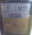
| + | *Arrived. -- [[User:Sourcerer|Sourcerer]] ([[User talk:Sourcerer|talk]]) [http://www.openstreetmap.org/?lat=52.46765614&lon=1.38499081&zoom=16&layers=B000FTF @52.4677,1.3850] 12:17, 13 March 2015 (GMT) | ||
| − | + | I'm not addicted. I know I said I wasn't geohashing. I can give it up any time I like! Stop bugging me (ChromeCrusaders)! | |
| − | + | ||
| − | + | Seriously though, I had a bit of time to kill before the broadband in my new house went live and the point was just over 3km away. This was posted from my new home. The expedition was routine. Drive, walk, shuffle, take a photo of some "Lords and Ladies" growing in the field margin, walk back and drive home. | |
| + | |||
| + | I'll add the photos once my data cable has moved house. | ||
== Photos == | == Photos == | ||
| − | |||
| − | |||
| − | |||
<gallery perrow="5"> | <gallery perrow="5"> | ||
| + | Image:2015-03-13 51 1 Sourcerer 1.jpg | Proof | ||
| + | Image:2015-03-13 51 1 Sourcerer 2.jpg | Lords and Ladies, Arum maculatum | ||
| + | Image:2015-03-13 51 1 Sourcerer 3.jpg | The Approach | ||
| + | Image:2015-03-13 51 1 Sourcerer 4.jpg | View from the Hashpoint | ||
</gallery> | </gallery> | ||
| − | == | + | {{Sourcerer_links |
| − | + | | prev = 2015-03-07 52 1 | |
| − | + | | curr = 2015-03-13 52 1 | |
| + | | next = 2015-04-08 52 1 | ||
| + | | date = 2015-03-13 | ||
| + | }} | ||
| − | |||
| − | |||
| − | |||
| − | |||
| − | |||
| − | |||
| − | |||
| − | |||
| − | |||
| − | |||
| − | |||
| − | |||
| − | |||
[[Category:Expeditions]] | [[Category:Expeditions]] | ||
| − | |||
[[Category:Expeditions with photos]] | [[Category:Expeditions with photos]] | ||
| − | |||
| − | |||
| − | |||
| − | |||
| − | |||
[[Category:Coordinates reached]] | [[Category:Coordinates reached]] | ||
| − | + | {{location|GB|ENG|NFK}} | |
| − | |||
| − | |||
| − | |||
| − | |||
| − | |||
| − | |||
| − | |||
| − | |||
| − | |||
| − | |||
| − | |||
| − | |||
| − | |||
| − | |||
| − | |||
| − | |||
| − | |||
Latest revision as of 03:00, 15 August 2019
| Fri 13 Mar 2015 in Norwich, UK: 52.4676646, 1.3849940 geohashing.info google osm bing/os kml crox |
Location
In a field close to a public right of way between Earsham and Bedingham, Norfolk, UK.
Participants
Expedition
- Arrived. -- Sourcerer (talk) @52.4677,1.3850 12:17, 13 March 2015 (GMT)
I'm not addicted. I know I said I wasn't geohashing. I can give it up any time I like! Stop bugging me (ChromeCrusaders)!
Seriously though, I had a bit of time to kill before the broadband in my new house went live and the point was just over 3km away. This was posted from my new home. The expedition was routine. Drive, walk, shuffle, take a photo of some "Lords and Ladies" growing in the field margin, walk back and drive home.
I'll add the photos once my data cable has moved house.
Photos
Proof
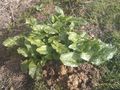
Lords and Ladies, Arum maculatum
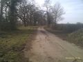
The Approach
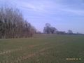
View from the Hashpoint


Expeditions and Plans
| 2015-03-13 | ||
|---|---|---|
| Mannheim, Germany | Q-Owl, Q-Owla | In the middle of the Maudacher Bruch near Ludwigshafen. |
| Norwich, United Kingdom | Sourcerer | In a field close to a public right of way between Earsham and Bedingham, No... |
Sourcerer's Expedition Links
2015-03-07 52 1 - 2015-03-13 52 1 - 2015-04-08 52 1 - KML file download of Sourcerer's expeditions for use with Google Earth.