Difference between revisions of "2015-03-15 49 8"
imported>Snoopy ([live picture] By the way home a look to the field [http://www.openstreetmap.org/?lat=49.09020260&lon=8.48837460&zoom=16&layers=B000FTF @49.0902,8.4884]) |
imported>FippeBot m (Location) |
||
| (15 intermediate revisions by 4 users not shown) | |||
| Line 1: | Line 1: | ||
| − | + | [[Image:{{{image|2015-03-15_49_8_DLichti_Stutensee.jpg}}}|thumb|left]] | |
| − | |||
| − | |||
| − | [[Image:{{{image| | ||
| − | |||
| − | |||
| − | |||
| − | |||
| − | |||
| − | |||
{{meetup graticule | {{meetup graticule | ||
| lat=49 | | lat=49 | ||
| Line 22: | Line 13: | ||
== Participants == | == Participants == | ||
| − | + | *[[User:DLichti|DLichti]] | |
| − | + | *[[User:Snoopy|Snoopy]] | |
| − | + | *[[User:DODO|DODO]] | |
== Plans == | == Plans == | ||
| Line 30: | Line 21: | ||
*A friend of mine and I plan to come. According to the train schedules, we would probably reach the HP at around 16:10.--[[User:DLichti|DLichti]] ([[User talk:DLichti|talk]]) 07:33, 14 March 2015 (EDT) | *A friend of mine and I plan to come. According to the train schedules, we would probably reach the HP at around 16:10.--[[User:DLichti|DLichti]] ([[User talk:DLichti|talk]]) 07:33, 14 March 2015 (EDT) | ||
*I plan to visit the geohash. It's in a field near Blankenloch. -- [[User:Snoopy|Snoopy]] ([[User talk:Snoopy|talk]]) [http://www.openstreetmap.org/?lat=49.04516670&lon=8.46338840&zoom=16&layers=B000FTF @49.0452,8.4634] 19:41, 13 March 2015 (EDT) | *I plan to visit the geohash. It's in a field near Blankenloch. -- [[User:Snoopy|Snoopy]] ([[User talk:Snoopy|talk]]) [http://www.openstreetmap.org/?lat=49.04516670&lon=8.46338840&zoom=16&layers=B000FTF @49.0452,8.4634] 19:41, 13 March 2015 (EDT) | ||
| − | * I want to visit this point by bike, but I can't come that late. I plan to start in Speyer at | + | * I want to visit this point by bike, but I can't come that late. I plan to start in Speyer at 12:30, so I will arrive between 14:30 and 15:00. What a pity, I'd love to meet DLichti [[2014-10-16 49 8|again]]. -- [[User:DODO|DODO]] ([[User talk:DODO|talk]]) |
== Expedition == | == Expedition == | ||
<!-- how it all turned out. your narrative goes here. --> | <!-- how it all turned out. your narrative goes here. --> | ||
| + | ===Snoopys story=== | ||
| + | *Arrive the hash at 08.50 -- [[User:Snoopy|Snoopy]] ([[User talk:Snoopy|talk]]) [http://www.openstreetmap.org/?lat=49.08570388&lon=8.48275339&zoom=16&layers=B000FTF @49.0857,8.4828] 03:55, 15 March 2015 (EDT) | ||
| + | ===DODOs story=== | ||
| + | I couldn't leave as soon as I had planned as I had to pick up little girl, which got here drivers license the day before yesterday and wanted to practice urgently. So I left home at 12:30 what was still far to early to meet DLichti and much to late to meet Snoopy on the other hand. It seems that I'm witched to earn 100 avoid each other-Achievements. I still choose to go there by bike. | ||
| + | |||
| + | The ride was rather uneventful. I started with a little detour so I could go for a tron achievement.It was colder than I had expected, with a fresh wind from the north but after a while I got warm and as I was riding southwards the wind came from the rear and I was much faster than expected. Well, at least until I got near Schloss Stutensee, where I saw a sign leading to a war memorial graveyard. This was a dilemma. I really wanted to see the memorial but I had no idea how far this would lead me and so had to take my bike with me, what would definitely destroy my tron. Well, I'm a cultural guy (and I didn't want to be responsible for you all not seeing any pictures of it). | ||
| + | |||
| + | So I first took a picture of castle Stutensee (which today houses an institution to help children) and then I found what I was looking for next to a paddock: a little graveyard with 15 graves. The castle was used as a military hospital at the end of WWII and these 15 men all died there in March 1945. | ||
| + | |||
| + | From there it was only some 100 m to the hash. Once again I had to enter a ploughed field. On my first attempt I had to walk 200 m into it but there was a path leading along the side of the field and so I could bring the muddy part down to 70m. As I could easily be seen from the close farmhouse I stayed as short as possible, just a proof and some further pictures, but not even a mark for DLichti (maybe he'll find my footsteps, but I didn't see any of snoopys footsteps either). | ||
| + | |||
| + | Back to my bike I had an apple and then rided on. Soon I reached Leopolfshafen, where I got some ice cream next to a funny house. Just a little bit further I reached a ferry, where I had to wait for a quarter of an hour again. I feared the way back, as the wind was still coming from the north, but the way lead me through some forest and so the wind couldn't stop me (except for the last 15 KM from Germersheim to Speyer). | ||
| + | |||
| + | === DLichti's story === | ||
| + | I left at around 13:45 to meet my friend in Karlsruhe where we took the line S2 to Blankenloch. At around 15:15, we arrived at Blankenloch Nord. From there, it was a 2.5 km walk to the HP. On our way, we came by a model airfield. Sice we didn't have any RC airplane to attempt a [[Geohash_by_proxy_achievement|proxy geohash achievement]] and there was nobody else we could have talked into giving us one, we continued by foot. | ||
| + | |||
| + | At around 15:50, we ventured westwards onto said field where we believed the HP to be located on. We were a little earlier than anticipated, but unfortnately still too late to meet DODO. Shortly before arriving at the HP, we discovered what we assumed to be an earlier geohasher's (probably DODO's?) footprints and followed them to the HP. We tried to leave a reference to [http://www.xkcd.com/426/ xkcd 426] but messed up the digits of the number. (German has a weird number system.) My friend brought some chococlate which we ate before leaving at around 16:10. | ||
| + | |||
| + | Like our two collegues, we didn't go home without having a look at the Stutensee residence. While exploring the environment, we also came by the little war cemetary and a wooden owl guarding the residence. | ||
| + | |||
| + | Our way to the next train stop took us through a small forest and along the railway tracks. We reached the Friedrichstal train stop at around 17:20 where we missed a train back to Karlsruhe by only a minute. But the next train was only 20 minutes later, so it wasn't too bad. | ||
| + | |||
| + | I stayed at my friend's place for supper and then took the last train home. At 22:15, I was home again. | ||
| − | |||
== Tracklog == | == Tracklog == | ||
<!-- if your GPS device keeps a log, you may post a link here --> | <!-- if your GPS device keeps a log, you may post a link here --> | ||
| + | [https://www.komoot.de/tour/4374847 80 KM bike] | ||
== Photos == | == Photos == | ||
| Line 44: | Line 58: | ||
Image:2012-##-## ## ## Alpha.jpg | Witty Comment | Image:2012-##-## ## ## Alpha.jpg | Witty Comment | ||
--> | --> | ||
| + | ===Snoopy=== | ||
<gallery perrow="5"> | <gallery perrow="5"> | ||
| Line 53: | Line 68: | ||
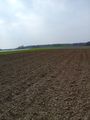
Image:2015-03-15_49_8_snoopy_1426406981622.jpg | By the way home a look to the field [http://www.openstreetmap.org/?lat=49.09020260&lon=8.48837460&zoom=16&layers=B000FTF @49.0902,8.4884] | Image:2015-03-15_49_8_snoopy_1426406981622.jpg | By the way home a look to the field [http://www.openstreetmap.org/?lat=49.09020260&lon=8.48837460&zoom=16&layers=B000FTF @49.0902,8.4884] | ||
| + | |||
| + | Image:2015-03-15_49_8_snoopy_1426405914000.jpg | proof photo from hash cause gps was at other pictures off [http://www.openstreetmap.org/?lat=49.05161820&lon=8.46344250&zoom=16&layers=B000FTF @49.0516,8.4634] | ||
| + | </gallery> | ||
| + | ===DODO=== | ||
| + | <gallery perrow="5"> | ||
| + | Image:2015-03-15_49_8-1.jpg | landscape near castle Stutensee. The bridge ist a former railway bridge | ||
| + | Image:2015-03-15_49_8-2.jpg | my first impression of the castle. | ||
| + | Image:2015-03-15_49_8-3.jpg | the castle again - Snoopy has the better picture | ||
| + | Image:2015-03-15_49_8-4.jpg | the school of the institution | ||
| + | Image:2015-03-15_49_8-5.jpg | These 15 men died (beyond others) in the military hospital in March 1945 | ||
| + | Image:2015-03-15_49_8-6.jpg | The graves of them and a part of my finger :-( | ||
| + | Image:2015-03-15_49_8-7.jpg | My first view to the hashpoint | ||
| + | Image:2015-03-15_49_8-8.jpg | proof | ||
| + | Image:2015-03-15_49_8-9.jpg | here I am | ||
| + | Image:2015-03-15_49_8-10.jpg | view to the west | ||
| + | Image:2015-03-15_49_8-11.jpg | and to the east. You see the farmhouse at the end of the field | ||
| + | Image:2015-03-15_49_8-12.jpg | my bike | ||
| + | Image:2015-03-15_49_8-13.jpg | KIT - Karlsruhe institute of technology - was on my way to | ||
| + | Image:2015-03-15_49_8-14.jpg | a house with many animals. I got some ice cream on the other side of the road. | ||
| + | Image:2015-03-15_49_8-15.jpg | a ferry again | ||
| + | </gallery> | ||
| + | |||
| + | === DLichti === | ||
| + | <gallery perrow="5"> | ||
| + | Image:2015-03-15_49_8_DLichti_Airfield.jpg | Model airfield near the HP. But nobody there to attempt a [[Geohash_by_proxy_achievement|proxy achievement]]. | ||
| + | Image:2015-03-15_49_8_DLichti_Footprint_1.jpg | An earlier geohasher's footprints ... | ||
| + | Image:2015-03-15_49_8_DLichti_Footprint 2.jpg | ... leading to ... | ||
| + | Image:2015-03-15_49_8_DLichti_proof.png | ... the hash point | ||
| + | Image:2015-03-15_49_8_DLichti_xkcd.jpg | Our mark at the HP | ||
| + | Image:2015-03-15_49_8_DLichti_bird.jpg | "What are those weird people doing on my field?" | ||
| + | Image:2015-03-15_49_8_DLichti_Stutensee.jpg | Yet another picture of Schloss Stutensee | ||
| + | Image:2015-03-15_49_8_DLichti_Owl.jpg | Another bird watching us | ||
| + | Image:2015-03-15_49_8_DLichti_Railway.jpg | We walked along the train tracks | ||
| + | Image:2015-03-15_49_8_DLichti_ICE.jpg | A high speed train on the way to Frankfurt ... | ||
| + | Image:2015-03-15_49_8_DLichti_freight_train.jpg | ... and a freight train following it | ||
</gallery> | </gallery> | ||
| Line 59: | Line 109: | ||
<!-- Add any achievement ribbons you earned below, or remove this section --> | <!-- Add any achievement ribbons you earned below, or remove this section --> | ||
| + | {{land geohash | ||
| + | | latitude = 49 | ||
| + | | longitude = 8 | ||
| + | | date = 2015-03-15 | ||
| + | | name = Snoopy and DODO | ||
| + | }} | ||
| + | |||
| + | |||
| + | {{gratuitous ribbon | ||
| + | | icon = Avoid achievement.png | ||
| + | | latitude = 49 | ||
| + | | longitude = 8 | ||
| + | | date = 2015-03-15 | ||
| + | | achievement = Avoid Each Other Achievement | ||
| + | | description = launching three independent expeditions without meeting up at the | ||
| + | | name = DODO, Snoopy and DLichti | ||
| + | }} | ||
| − | |||
| − | |||
| − | |||
| − | + | {{bicycle geohash | |
| + | | latitude = 49 | ||
| + | | longitude = 8 | ||
| + | | date = 2015-03-15 | ||
| + | | name = DODO | ||
| + | | distance = 80 KM | ||
| + | }} | ||
| − | |||
| − | |||
| − | |||
| − | |||
| − | |||
[[Category:Expeditions]] | [[Category:Expeditions]] | ||
| − | |||
[[Category:Expeditions with photos]] | [[Category:Expeditions with photos]] | ||
| − | |||
| − | |||
| − | |||
| − | |||
| − | |||
[[Category:Coordinates reached]] | [[Category:Coordinates reached]] | ||
| − | + | {{location|DE|BW|KA}} | |
| − | |||
| − | |||
| − | |||
| − | |||
| − | |||
| − | |||
| − | |||
| − | |||
| − | |||
| − | |||
| − | |||
| − | |||
| − | |||
| − | |||
| − | |||
| − | |||
| − | |||
Latest revision as of 03:02, 15 August 2019

| Sun 15 Mar 2015 in 49,8: 49.0847603, 8.4831429 geohashing.info google osm bing/os kml crox |
Location
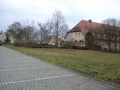
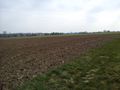
On a field next to Schloss Stutensee.
Participants
Plans
- A friend of mine and I plan to come. According to the train schedules, we would probably reach the HP at around 16:10.--DLichti (talk) 07:33, 14 March 2015 (EDT)
- I plan to visit the geohash. It's in a field near Blankenloch. -- Snoopy (talk) @49.0452,8.4634 19:41, 13 March 2015 (EDT)
- I want to visit this point by bike, but I can't come that late. I plan to start in Speyer at 12:30, so I will arrive between 14:30 and 15:00. What a pity, I'd love to meet DLichti again. -- DODO (talk)
Expedition
Snoopys story
- Arrive the hash at 08.50 -- Snoopy (talk) @49.0857,8.4828 03:55, 15 March 2015 (EDT)
DODOs story
I couldn't leave as soon as I had planned as I had to pick up little girl, which got here drivers license the day before yesterday and wanted to practice urgently. So I left home at 12:30 what was still far to early to meet DLichti and much to late to meet Snoopy on the other hand. It seems that I'm witched to earn 100 avoid each other-Achievements. I still choose to go there by bike.
The ride was rather uneventful. I started with a little detour so I could go for a tron achievement.It was colder than I had expected, with a fresh wind from the north but after a while I got warm and as I was riding southwards the wind came from the rear and I was much faster than expected. Well, at least until I got near Schloss Stutensee, where I saw a sign leading to a war memorial graveyard. This was a dilemma. I really wanted to see the memorial but I had no idea how far this would lead me and so had to take my bike with me, what would definitely destroy my tron. Well, I'm a cultural guy (and I didn't want to be responsible for you all not seeing any pictures of it).
So I first took a picture of castle Stutensee (which today houses an institution to help children) and then I found what I was looking for next to a paddock: a little graveyard with 15 graves. The castle was used as a military hospital at the end of WWII and these 15 men all died there in March 1945.
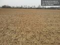
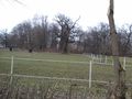
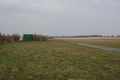
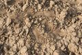
From there it was only some 100 m to the hash. Once again I had to enter a ploughed field. On my first attempt I had to walk 200 m into it but there was a path leading along the side of the field and so I could bring the muddy part down to 70m. As I could easily be seen from the close farmhouse I stayed as short as possible, just a proof and some further pictures, but not even a mark for DLichti (maybe he'll find my footsteps, but I didn't see any of snoopys footsteps either).
Back to my bike I had an apple and then rided on. Soon I reached Leopolfshafen, where I got some ice cream next to a funny house. Just a little bit further I reached a ferry, where I had to wait for a quarter of an hour again. I feared the way back, as the wind was still coming from the north, but the way lead me through some forest and so the wind couldn't stop me (except for the last 15 KM from Germersheim to Speyer).
DLichti's story
I left at around 13:45 to meet my friend in Karlsruhe where we took the line S2 to Blankenloch. At around 15:15, we arrived at Blankenloch Nord. From there, it was a 2.5 km walk to the HP. On our way, we came by a model airfield. Sice we didn't have any RC airplane to attempt a proxy geohash achievement and there was nobody else we could have talked into giving us one, we continued by foot.
At around 15:50, we ventured westwards onto said field where we believed the HP to be located on. We were a little earlier than anticipated, but unfortnately still too late to meet DODO. Shortly before arriving at the HP, we discovered what we assumed to be an earlier geohasher's (probably DODO's?) footprints and followed them to the HP. We tried to leave a reference to xkcd 426 but messed up the digits of the number. (German has a weird number system.) My friend brought some chococlate which we ate before leaving at around 16:10.
Like our two collegues, we didn't go home without having a look at the Stutensee residence. While exploring the environment, we also came by the little war cemetary and a wooden owl guarding the residence.
Our way to the next train stop took us through a small forest and along the railway tracks. We reached the Friedrichstal train stop at around 17:20 where we missed a train back to Karlsruhe by only a minute. But the next train was only 20 minutes later, so it wasn't too bad.
I stayed at my friend's place for supper and then took the last train home. At 22:15, I was home again.
Tracklog
Photos
Snoopy
Here we are @49.0860,8.4833
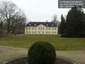
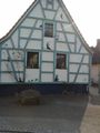
The Schloss Stutensee @49.0729,8.4721
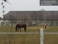
Not far away @49.0919,8.4767
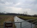
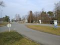
By the way home a look to the field @49.0902,8.4884
proof photo from hash cause gps was at other pictures off @49.0516,8.4634


DODO
landscape near castle Stutensee. The bridge ist a former railway bridge
my first impression of the castle.
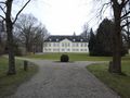
the castle again - Snoopy has the better picture
the school of the institution
These 15 men died (beyond others) in the military hospital in March 1945
The graves of them and a part of my finger :-(
My first view to the hashpoint
proof

here I am
view to the west
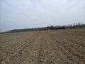
and to the east. You see the farmhouse at the end of the field
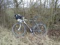
my bike
KIT - Karlsruhe institute of technology - was on my way to
a house with many animals. I got some ice cream on the other side of the road.
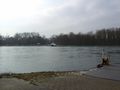
a ferry again


DLichti
Model airfield near the HP. But nobody there to attempt a proxy achievement.

An earlier geohasher's footprints ...
... leading to ...
... the hash point

Our mark at the HP
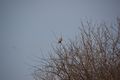
"What are those weird people doing on my field?"

Yet another picture of Schloss Stutensee
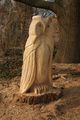
Another bird watching us

We walked along the train tracks
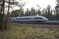
A high speed train on the way to Frankfurt ...
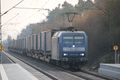
... and a freight train following it


Achievements
Snoopy and DODO earned the Land geohash achievement
|
DODO, Snoopy and DLichti earned the Avoid Each Other Achievement
|
DODO earned the Bicycle geohash achievement
|